Situation Summary
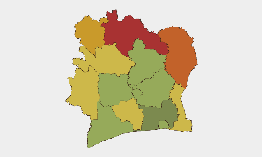
Ivory Coast remains a low-frequency threat environment globally (composite score 17) with no tracked discrete security events in the current reporting window. However, risk is heavily concentrated in the northern and northwestern border districts, where historical trafficking, militant movement, and cross-border instability create persistent vulnerability. The absence of recent incident reporting does not indicate reduced underlying threat; rather, it reflects the chronic, low-visibility nature of risks in those zones.
Key Developments
No discrete security events have been confirmed in Ivory Coast during the last 24–48 hours. GeoBit's event signal database reports zero tracked incidents in the current window. Verification of any alleged recent incidents (crime, unrest, protest, or militant activity) requires real-time web and social-media triage, which is outside the scope of this briefing. Corporate security teams should contact GeoBit's Intel Sweep or OSINT fusion services with specific incident reports or source links for same-day corroboration.
Highest-Risk Areas
Risk is overwhelmingly concentrated in the Savanes (78), Zanzan (75), and Denguélé (72) districts in Ivory Coast's far north and northwest, bordering Mali and Burkina Faso. These zones are characterized by porous borders, limited state presence, human-trafficking corridors, and historical activity by militant groups transiting the Sahel. Comoé (70) and Montagnes (68) districts, also in the north, extend this vulnerability eastward. By contrast, Abidjan (45), the capital and economic hub, ranks lowest among tracked regions, though it remains a hub for organized crime, petty violence, and occasional civil unrest. Northern risk drivers include cross-border movement, resource trafficking, and weak administrative control; southern risk is dominated by urban crime and political tensions.
How GeoBit Would Assist
Security teams with personnel or assets in Ivory Coast should deploy AOI Monitoring & Early Warning on the Savanes, Zanzan, and Denguélé districts to detect emerging militant activity, trafficking surges, or border incursions in near-real time. Intel Sweep combined with multi-language OSINT (French and local-language social media, radio SIGINT, and Telegram networks) will surface credible incident reports, threat actor communications, and civil unrest hours or days before mainstream reporting. Routing & Network Analysis can identify safer and alternative travel corridors within high-risk districts. For strategic context, regime-stability and border-dispute search capabilities support longer-term risk modeling and duty-of-care planning.
7-Day Outlook
No imminent triggering events are evident in current reporting. Northern districts will likely remain in a state of chronic, low-visibility instability driven by cross-border trafficking and weak governance. Abidjan and other southern urban centers should be monitored for political or labor-related civil unrest, but the near-term trajectory suggests continuation of baseline risk rather than acute escalation. Security teams should maintain persistent monitoring and be prepared to activate contingency protocols if OSINT or field reporting suggests a sharp increase in militant presence or organized violence.
Highest-Risk Areas — Ranked
| # | State / Region | Risk |
|---|---|---|
| 1 | Savanes District | 78 |
| 2 | Zanzan District | 75 |
| 3 | Denguélé District | 72 |
| 4 | Comoé District | 70 |
| 5 | Montagnes District | 68 |
| 6 | Woroba District | 65 |
| 7 | Gôh-Djiboua District | 60 |
| 8 | Sassandra-Marahoué District | 58 |
| 9 | Vallée du Bandama District | 55 |
| 10 | Bas-Sassandra District | 52 |
| 11 | Lacs District | 48 |
| 12 | Abidjan | 45 |
Sources
Previous Daily Briefs
A new Ivory Coast brief is written every day — each with its own risk map and downloadable CSV. Here's the last week; use the calendar to go further back.
📅 Browse every day by calendar →
Highlighted days have a brief. Tap a day for that day's map & analysis, or “csv” for that day's dataset ($5).
Atlas — our AI intelligence desk — emails them this snapshot personally. Nothing else, no list.