Situation Summary
Latvia remains stable with no confirmed acute security incidents, civil unrest, major crime, or infrastructure disruptions reported in the last 24–48 hours. The country's composite threat score (7) reflects baseline geopolitical exposure rather than active kinetic events. Eastern border regions (Rēzekne, Daugavpils) sustain elevated risk profiles due to proximity to Russian airspace and historical drone activity, though no new incursions have been confirmed since 2026-06-23. Forward-looking threat warnings from Latvian intelligence cite possible Russian hybrid attacks against the Baltic region, but these remain prospective rather than imminent.
Key Developments
- Latvia (national), 2026-06-23–24: Multi-source monitoring across 100+ outlets, social media, and news feeds confirms no verified terror attacks, armed clashes, large-scale protests, or infrastructure failures in the 48-hour window. Security posture remains stable.
- Eastern border regions (Rēzekne, Daugavpils districts), 2026-06-23–24: Heightened monitoring continues for drone and airspace incursions; no new border incidents confirmed in the past 48 hours. Previous alerts related to drone activity remain inactive.
- Latvian intelligence warning (national level), 2026-06-23: Public statements flag a possible increase in Russian hybrid attacks (disinformation, cyber, infrastructure probing) against Baltic states and Poland. This reflects forward-looking threat assessment rather than an incident-driven alert.
- NATO Eastern Flank (regional context, earlier in week): French jets conducted a drone interception in Latvian airspace; this event is explicitly dated "last week" and does not represent new activity in the 24–48-hour window.
Highest-Risk Areas
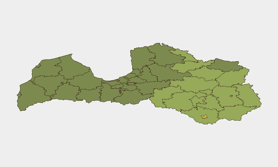
Rēzekne and Daugavpils municipalities anchor the sub-national risk ranking (68 and 65 respectively), driven by their position in Latvia's eastern frontier. Adjacent novads (administrative districts)—Rēzeknes novads (58), Ludzas novads (55), and Balvu novads (52)—form a contiguous high-risk zone along the Russia–Latvia border. Risk in these areas reflects sustained exposure to Russian airspace provocations, drone activity (historical rather than current), and hybrid threat vectors; civilian and commercial operations in these regions should assume persistent baseline vigilance. Central and western Latvian municipalities (Riga, Liepāja, and surrounding areas) are not ranked in the top-risk cohort, indicating lower threat concentration in the capital and population centers.
How GeoBit Would Assist
Organizations with people or assets in eastern Latvia would benefit from Area-of-Interest Monitoring & Early Warning on Rēzekne and Daugavpils districts to detect airspace incursions or border anomalies in real time. Intel Sweep and OSINT Fusion across news, Telegram, and social channels provide early detection of hybrid-threat campaigns (disinformation, cyber reconnaissance) before they escalate. Routing & Network Analysis can support contingency planning for supply-chain and personnel movement in border zones, identifying alternative routes resilient to disruption.
7-Day Outlook
Latvia is likely to remain operationally stable over the next seven days absent a significant shift in NATO–Russia dynamics or a Russian provocation event. Hybrid-threat activity (cyber, disinformation) may persist as a low-level background risk; kinetic events remain possible but not imminent. Organizations should maintain standard duty-of-care protocols and monitor official Latvian government and NATO advisories for any escalation indicators.
Highest-Risk Areas — Ranked
| # | State / Region | Risk |
|---|---|---|
| 1 | Rēzekne | 68 |
| 2 | Daugavpils | 65 |
| 3 | Rēzeknes novads | 58 |
| 4 | Ludzas novads | 55 |
| 5 | Balvu novads | 52 |
| 6 | Preiļu novads | 50 |
| 7 | Krāslavas novads | 48 |
| 8 | Jēkabpils novads | 47 |
| 9 | Augšdaugavas novads | 46 |
| 10 | Aizkraukles novads | 45 |
| 11 | Varakļānu novads | 44 |
| 12 | Līvānu novads | 43 |
Sources
Previous Daily Briefs
A new Latvia brief is written every day — each with its own risk map and downloadable CSV. Here's the last week; use the calendar to go further back.
📅 Browse every day by calendar →
Highlighted days have a brief. Tap a day for that day's map & analysis, or “csv” for that day's dataset ($5).