Situation Summary
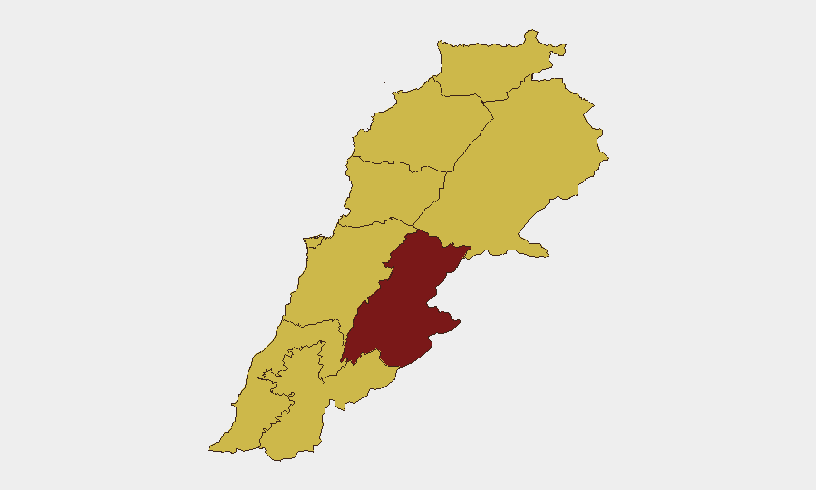
Lebanon remains the 14th highest-threat country globally (composite score 94) amid escalating diplomatic tensions, military posturing, and localized instability. The past 48 hours have seen a confluence of international pressure, Iranian threats, and domestic military/political friction that compounds underlying fragility in governance and armed non-state actor presence. The Beqaa Governorate continues to drive sub-national risk (95.7), reflecting longstanding militant and Iranian-aligned group activity. Overall trajectory is toward increased volatility rather than stabilization.
Key Developments
- 2026-07-03, nationwide – Prime Minister rejected unspecified demand and Lebanon rejected military action, signaling internal governance friction and possible external pressure to take military steps against armed groups.
- 2026-07-03, nationwide – Iran made public statement and conveyed threats toward Lebanon, consistent with Iranian efforts to influence Lebanese state and non-state actors; timing and specifics require urgent clarification.
- 2026-07-03, nationwide – Conventional military force event recorded; source and target remain unclear from signal metadata but indicate active military activity or deployment.
- 2026-07-02, nationwide – US signaled reduction in relations with Lebanon, likely tied to governance, Hezbollah linkages, or counter-terrorism disputes; escalation of diplomatic isolation.
- 2026-07-01, multiple locations – Artillery/tank deployments by regime forces reported; physical assault incidents recorded within Lebanon, suggesting internal armed friction or enforcement actions.
- 2026-07-01, nationwide – Iran threatened Lebanon; Lebanese state issued disapproval statement; indicative of external pressure and internal rejection of foreign demands.
*Note: Web research was insufficient to independently verify incident-level granularity for all signals; GeoBit event taxonomy confirms escalation trend but operational specifics require additional source confirmation.*
Highest-Risk Areas
Beqaa Governorate (95.7) remains exceptional risk—historically a stronghold for Iranian-backed militant infrastructure, Hezbollah logistics, and Syrian refugee-related instability. The 26-point gap between Beqaa and Beirut (69.1) reflects concentration of armed-group activity, weapons stockpiles, and cross-border trafficking. Beirut, Keserwan-Jbeil, and the northern/southern governorates (65.7–69.1) show elevated but more uniform risk, driven by political volatility, sectarian tensions, and proximity to security flashpoints. Beqaa's outsized score warrants focused asset and personnel risk mitigation.
How GeoBit Would Assist
Security teams should prioritize Area-of-Interest Monitoring & Early Warning on the Beqaa Governorate, southern border regions, and Beirut's critical infrastructure to detect militant activity, weapons movements, and cross-border incursions before escalation. Conflict & Military tracking (force structure, weapons-capability, battle-mapping) combined with OSINT fusion (X/Telegram, multi-language feeds, entity extraction) will clarify the current military posture, Iranian pressure vectors, and Prime Minister's constraints in real time. Routing & Network Analysis and satellite imagery enable alternative-route planning and asset repositioning out of high-risk zones.
7-Day Outlook
International pressure on Lebanon (US diplomatic downgrade, Iranian threats) will likely intensify, pushing the government toward either capitulation or military action against non-state actors—both carry escalation risk. Beqaa Governorate and southern border areas should be assumed under heightened militant alert status. Personnel and asset exposure in Beirut and transit routes should be reassessed daily; duty-of-care teams should consider temporary movement restrictions or evacuation protocols if Prime Minister rejects military demands or Iran escalates rhetoric.
Highest-Risk Areas — Ranked
| # | State / Region | Risk |
|---|---|---|
| 1 | Beqaa Governorate | 95.7 |
| 2 | Beirut Governorate | 69.1 |
| 3 | Keserwan-Jbeil Governorate | 67.4 |
| 4 | North Governorate | 65.7 |
| 5 | Akkar Governorate | 65.7 |
| 6 | Mount Lebanon Governorate | 65.7 |
| 7 | South Governorate | 65.7 |
| 8 | Nabatieh Governorate | 65.7 |
| 9 | Baalbek-Hermel Governorate | 65.7 |
Sources
Previous Daily Briefs
A new Lebanon brief is written every day — each with its own risk map and downloadable CSV. Here's the last week; use the calendar to go further back.
📅 Browse every day by calendar →
Highlighted days have a brief. Tap a day for that day's map & analysis, or “csv” for that day's dataset ($5).