Situation Summary
Lesotho remains stable with no confirmed security incidents in the past 24–48 hours and no tracked discrete events across the country. The overall threat environment is low (global rank #144, composite score 6), with no reports of armed conflict, civil unrest, organized crime activity, or political instability in the current window. Risk concentration remains localized in urban Maseru District and secondary urban centers; border infrastructure has experienced weather-related disruption but poses no direct security threat.
Key Developments
- Nationwide — *Last 24–48 hours* — No verified protests, roadblocks, armed clashes, kidnappings, or high-profile crime events were detected across monitored regional outlets, local news sources, government channels, and social media feeds.
- Maseru District & surrounding urban areas — *Last 24–48 hours* — No new discrete incident confirmed; however, this district remains the primary sub-national risk concentration point and warrants routine monitoring by corporate security teams with personnel or assets present.
- Qacha's Nek Port of Entry (SA–Lesotho border) — *3 August 2026* — Heavy snowfall temporarily suspended Border Management Authority operations, disrupting cross-border vehicle and cargo movement. While resolved, this event flags weather vulnerability in alpine border infrastructure; similar disruptions are likely during winter months.
- No civil-unrest signals detected — *Last 24–48 hours* — Open-source monitoring, social media sentiment analysis, and multi-language news aggregation recorded no inflammatory political rhetoric, protest mobilization, or organizational messaging indicative of imminent civil disorder.
- Nationwide security posture — *Assessed as stable* — No tracked incidents in the current window; no credible reports of kidnapping, extortion, armed gang activity, or inter-communal violence in the last 48 hours.
Highest-Risk Areas
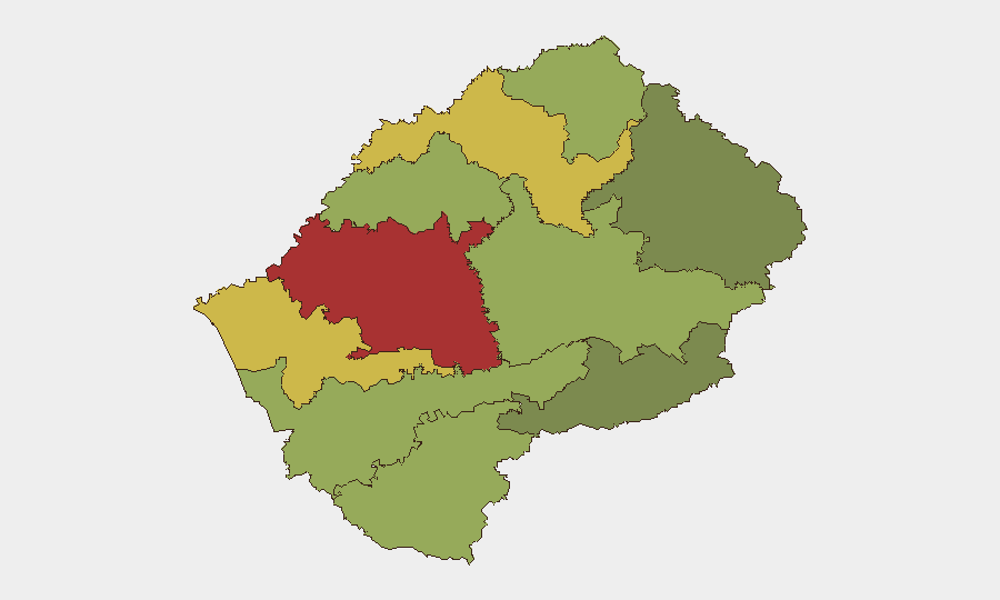
Maseru District (risk score 78) drives the country's overall risk concentration, followed by secondary urban corridors in Mafeteng (65) and Leribe (62) districts. Risk in these zones reflects urban crime density, informal settlement sprawl, limited police presence, and economic marginalization rather than political instability or armed conflict. Rural and border districts (Qacha's Nek, Mokhotlong) present lower baseline risk but face seasonal weather disruption and limited emergency response infrastructure. Corporate teams should calibrate duty-of-care protocols around urban-area presence in Maseru and secondary towns rather than assume nationwide threat.
How GeoBit Would Assist
Security teams monitoring Lesotho should employ AOI (Area-of-Interest) Monitoring & Early Warning focused on Maseru District and key border crossings to detect civil unrest, roadblock formation, or security force deployment with real-time alerting. OSINT fusion and multi-language sentiment analysis on social media, local news, and regional outlets will continue to flag emerging political or labor tension before incident escalation. Routing & Network Analysis is operationally useful for duty-of-care teams planning personnel movement, especially during winter months when border infrastructure becomes vulnerable to weather disruption.
7-Day Outlook
No near-term threat escalation is forecast. Lesotho's political and security environment is expected to remain stable over the next 7 days absent external regional shocks. Winter weather patterns (snowfall, ice, temperature extremes) will likely persist in highland and border zones, creating infrastructure disruption risk; security teams should plan supply-chain and personnel routing with alternate crossing points and weather forecasting in mind.
Highest-Risk Areas — Ranked
| # | State / Region | Risk |
|---|---|---|
| 1 | Maseru District | 78 |
| 2 | Mafeteng District | 65 |
| 3 | Leribe District | 62 |
| 4 | Berea District | 58 |
| 5 | Mohale's Hoek District | 52 |
| 6 | Butha-Buthe District | 48 |
| 7 | Thaba-Tseka District | 45 |
| 8 | Quthing District | 42 |
| 9 | Mokhotlong District | 38 |
| 10 | Qacha's Nek District | 28 |
Sources
Previous Daily Briefs
A new Lesotho brief is written every day — each with its own risk map and downloadable CSV. Here's the last week; use the calendar to go further back.
📅 Browse every day by calendar →
Highlighted days have a brief. Tap a day for that day's map & analysis, or “csv” for that day's dataset ($5).
Atlas — our AI intelligence desk — emails them this snapshot personally. Nothing else, no list.