Situation Summary
Liberia remains at a low acute-threat level (global rank #134, composite score 7) with no confirmed security incidents, civil unrest, or transport disruptions recorded in the past 24–48 hours. Historical and ongoing government investigations into drug trafficking, official misconduct, and custodial deaths continue in Monrovia and provincial locations, but these do not constitute current escalation. The security environment is characterized by endemic regional fragility in border counties and law-enforcement activity rather than active conflict or organized unrest.
Key Developments
No confirmed security, conflict, civil-unrest, crime, or infrastructure incidents were verified in Liberia during the 24–48-hour window ending 2026-08-08. Older investigative activity includes:
- Monrovia, Aug. 7: Ongoing Justice Ministry and LDEA drug-trafficking investigation with multiple officials under review.
- Bong County, Aug. 7: Police investigation into a woman's death in Fuamah District remains under inquiry.
- Monrovia, Aug. 3–5: Continuation of government security review involving dismissal and interrogation of senior officials linked to earlier allegations.
Assessment: These are investigative/administrative actions, not acute security incidents. No elevated threat level or public unrest tied to them has been reported.
Highest-Risk Areas
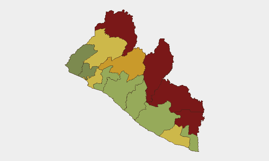
Nimba, Lofa, and Grand Gedeh counties present the highest composite risk scores (92, 88, and 85 respectively), driven by border proximity, limited state capacity, historical trafficking networks, and cross-border population movement. Bong County (rank 5, score 72) has appeared in recent police investigations and reflects ongoing law-enforcement activity in provincial zones. Montserrado County (rank 8, score 64), encompassing Monrovia, carries moderate risk tied to investigative and administrative operations. The frontier belt—particularly the Guinea and Sierra Leone borders—remains the primary locus of organized crime, informal commerce, and weak governance; corporate and NGO operations in these zones require sustained monitoring and contingency planning.
How GeoBit Would Assist
Intel Sweep and OSINT fusion capabilities enable continuous monitoring of web, social media, and local radio for early signals of unrest, official instability, or transport disruption affecting operations. AOI Monitoring & Early Warning with persistent geospatial alerting can flag activity changes in high-risk counties (Nimba, Lofa, Grand Gedeh) and corridor routes. Routing & Network Analysis supports real-time alternative journey planning for personnel and asset movements, particularly through Montserrado and border crossings, reducing exposure to investigative checkpoints or informal taxation.
7-Day Outlook
No acute escalation is anticipated in the near term. Ongoing administrative and investigative actions in Monrovia are unlikely to generate public unrest or broad security disruption. Border-county endemic risks (trafficking, informal armed activity, communal disputes) will persist but remain localized; personnel and asset security will depend on situational awareness and route flexibility rather than systemic threat elevation.
Highest-Risk Areas — Ranked
| # | State / Region | Risk |
|---|---|---|
| 1 | Nimba County | 92 |
| 2 | Lofa County | 88 |
| 3 | Grand Gedeh County | 85 |
| 4 | River Gee County | 83 |
| 5 | Bong County | 72 |
| 6 | Gbarpolu County | 68 |
| 7 | Grand Kru County | 65 |
| 8 | Montserrado County | 64 |
| 9 | Rivercess County | 58 |
| 10 | Sinoe County | 55 |
| 11 | Margibi County | 52 |
| 12 | Grand Bassa County | 48 |
Sources
Previous Daily Briefs
A new Liberia brief is written every day — each with its own risk map and downloadable CSV. Here's the last week; use the calendar to go further back.
📅 Browse every day by calendar →
Highlighted days have a brief. Tap a day for that day's map & analysis, or “csv” for that day's dataset ($5).
Atlas — our AI intelligence desk — emails them this snapshot personally. Nothing else, no list.