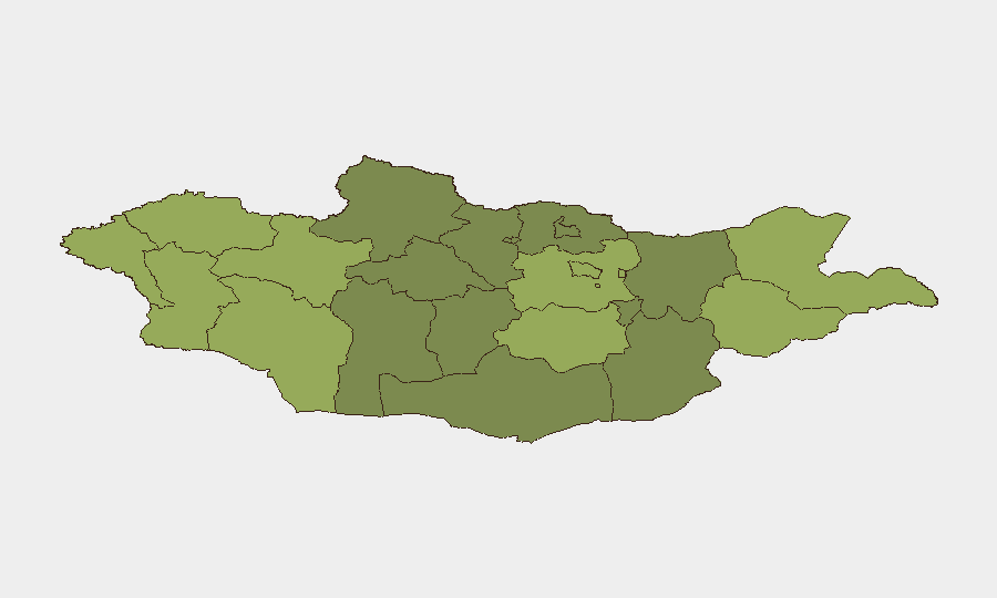
Situation Summary
Mongolia remains a low-threat environment by global standards (composite threat score 4), with no major security incidents confirmed in the past 24–48 hours. Underlying risks persist in zoonotic disease (measles, plague) and isolated criminal incidents; however, the absence of civil unrest, terrorism, or armed conflict maintains the country's relative stability. Border regions—particularly Dornod, Sükhbaatar, Uvs, and Khovd—register elevated composite risk scores, driven primarily by remote geography, limited state presence, and cross-border health/wildlife hazards rather than active security events.
Key Developments
No discrete security or travel-risk incidents were confirmed within the last 24–48 hours across open-source reporting and social media monitored by GeoBit.
Context and background hazards (not current events, but ongoing monitoring triggers):
- Measles transmission (nationwide, as of July 24): 15,557 confirmed cases remain active, with 12,416 concentrated in Ulaanbaatar and 3,136 in provinces; two new cases recorded in the latest 24-hour epidemiological window. Health authorities continue routine surveillance but no acute incident escalation is documented.
- Plague risk warnings (issued earlier in July, across 17 of 21 provinces): A confirmed human plague infection linked to marmot exposure was registered in Jargalant district, Khovd province on July 20 (outside the 24–48-hour window); a suspected bubonic plague case from marmot consumption is undergoing PCR testing in Bayan-Ülgii. Seasonal risk advisory remains in effect but no new index cases are confirmed in the current window.
- Tourist assault (northern Mongolia, date unconfirmed): Multiple briefings reference an assault on six Israeli tourists at a remote campsite, with one evacuated for jaw fracture treatment; no precise date is available, so it cannot be reliably classified as a recent event.
- Highway toll policy (effective August 1): Government-approved increases (cars MNT 1,000 → 5,000; trucks MNT 10,000 → 20,000) will affect logistics and travel routing from next month onwards; not a 24–48-hour incident but operationally relevant for supply-chain and personnel movement planning.
Highest-Risk Areas
Dornod (58), Sükhbaatar (55), Uvs (52), and Khovd (50) dominate Mongolia's sub-national risk profile, reflecting border-zone vulnerabilities, sparse population density, and limited infrastructure rather than acute conflict or terrorism. Ulaanbaatar (45) and central aimags (Töv, Dundgovi) carry moderate risk driven by crime and health hazards. Eastern and western aimags face compounded exposure to zoonotic spillover (plague, wildlife contact), cross-border movement, and distance from emergency services; organizations with personnel or assets in these zones should maintain heightened health screening and evacuation protocols.
How GeoBit Would Assist
Security teams should deploy AOI Monitoring & Early Warning on border aimags (Dornod, Sükhbaatar, Khovd) to track cross-border movement, animal-health alerts, and settlement incidents in real time. Environmental & Health intelligence (plague advisories, measles epidemiology, seasonal zoonotic patterns) combined with OSINT fusion (local news, Telegram, social media sentiment) provides early signals of health crises or civil unrest before they affect operations. Routing & Network Analysis will support alternative journey planning as toll increases take effect next month and security posture shifts in remote areas.
7-Day Outlook
No acute security deterioration is expected in the next week. Measles and plague surveillance will remain steady-state monitoring priorities; travelers and staff in western/eastern aimags should maintain health precautions. Highway toll implementation on August 1 will require logistical adjustments but poses no direct security risk.
Highest-Risk Areas — Ranked
| # | State / Region | Risk |
|---|---|---|
| 1 | Dornod | 58 |
| 2 | Sükhbaatar | 55 |
| 3 | Uvs | 52 |
| 4 | Khovd | 50 |
| 5 | Bayan-Ölgii | 48 |
| 6 | Govi-Altai | 46 |
| 7 | Ulaanbaatar | 45 |
| 8 | Zavkhan | 44 |
| 9 | Töv | 42 |
| 10 | Dundgovi | 40 |
| 11 | Darkhan-Uul | 38 |
| 12 | Ömnögovi | 37 |
Sources
Previous Daily Briefs
A new Mongolia brief is written every day — each with its own risk map and downloadable CSV. Here's the last week; use the calendar to go further back.
📅 Browse every day by calendar →
Highlighted days have a brief. Tap a day for that day's map & analysis, or “csv” for that day's dataset ($5).
Atlas — our AI intelligence desk — emails them this snapshot personally. Nothing else, no list.