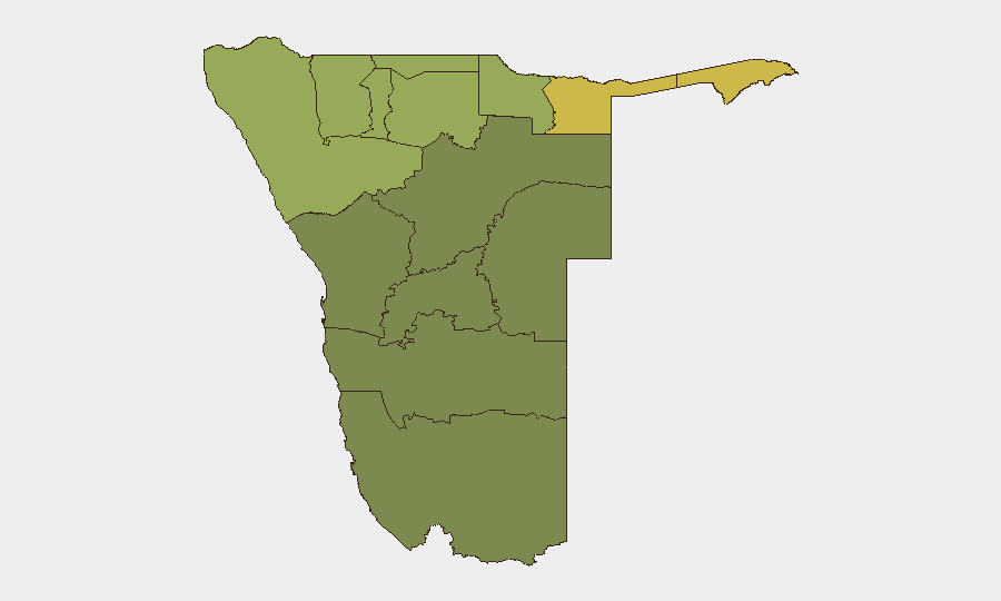
Situation Summary
Namibia remains a low-threat environment globally (rank #162, composite score 5) with stable governance and limited active conflict. However, sub-national risk is concentrated in the northern border regions—particularly Zambezi, Kavango East, and Kavango West—where cross-border activity, resource disputes, and land-use tensions create elevated exposure. Current event signals indicate isolated tensions between residents and city authorities in Windhoek, and ongoing land disputes involving farmers, but no confirmed major security incidents in the last 24–48 hours have been time-verified through independent sources.
Key Developments
Note: Live web research conducted over the last 24 hours did not yield reliably dated, independently verified security or unrest incidents occurring within the last 24–48 hours in Namibia. The GEOBIT platform's event feed shows seven tracked signals (including threats to residents and businesses in Windhoek, military-related farmer disputes, and territorial/sanctions signals), but these require further corroboration and temporal confirmation. Corporate security teams should note that public reporting on Namibian security incidents is sparse and often unattributed; GeoBit's ongoing AOI monitoring and OSINT fusion capabilities are actively tracking these developments for updated confirmation.
Highest-Risk Areas
Northern border regions drive sub-national risk significantly. Zambezi (68), Kavango East (62), and Kavango West (58) account for the highest composite threats, reflecting cross-border movement, wildlife poaching networks, illegal fishing, and land-use conflicts with conservation stakeholders. Kunene Region (52) follows, likely driven by similar border dynamics and resource tensions. By contrast, central and southern regions (Hardap, Omaheke, Otjozondjupa) remain substantially lower-risk. The disparity reflects Namibia's exposure to transnational criminal flows and disputed resource management rather than state-level instability. Teams with assets or personnel in the north should maintain elevated situational awareness and contingency protocols.
How GeoBit Would Assist
Security and risk teams operating in Namibia would benefit from AOI Monitoring & Early Warning on Zambezi and Kavango regions—persistent watch with alert thresholds on cross-border movement, poaching indicators, and civil unrest. OSINT Fusion & Corroboration across news, social platforms (X, Instagram, Facebook), radio SIGINT, and imagery analysis is essential to filter signal from noise, given sparse formal reporting on rural and border incidents. GIS & Spatial Analysis paired with Routing & Network Analysis would enable identification of safer movement corridors and real-time alternative route planning for personnel traveling between Windhoek and northern operations. Conflict & Military and Network & Actor Analysis capabilities support tracking of key stakeholders (farmer groups, conservation bodies, cross-border networks) and their posture shifts.
7-Day Outlook
No major escalation is anticipated in the near term; Namibia's institutional stability and weak organizational capacity among non-state actors limit rapid conflict spread. Land and resource tensions, particularly in northern regions and between conservation groups and residents, will likely persist as chronic, low-intensity friction rather than acute crisis. Continued monitoring of Windhoek political signals and Zambezi/Kavango cross-border activity is warranted to detect early shifts in threat trajectory.
Highest-Risk Areas — Ranked
| # | State / Region | Risk |
|---|---|---|
| 1 | Zambezi | 68 |
| 2 | Kavango East | 62 |
| 3 | Kavango West | 58 |
| 4 | Kunene Region | 52 |
| 5 | Oshikoto | 48 |
| 6 | Ohangwena | 45 |
| 7 | Omusati | 42 |
| 8 | Oshana | 40 |
| 9 | Otjozondjupa | 35 |
| 10 | Erongo Region | 32 |
| 11 | Hardap | 28 |
| 12 | Omaheke | 25 |
Sources
Previous Daily Briefs
A new Namibia brief is written every day — each with its own risk map and downloadable CSV. Here's the last week; use the calendar to go further back.
📅 Browse every day by calendar →
Highlighted days have a brief. Tap a day for that day's map & analysis, or “csv” for that day's dataset ($5).
Atlas — our AI intelligence desk — emails them this snapshot personally. Nothing else, no list.