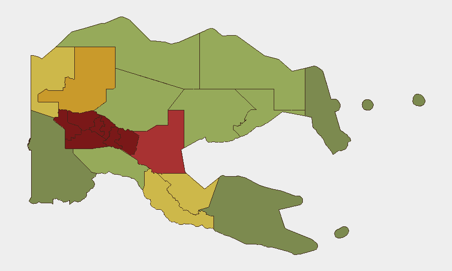
Situation Summary
Papua New Guinea remains at elevated baseline risk, with security pressure concentrated in the highland provinces (Southern Highlands, Enga, Hela, Eastern Highlands, and Western Highlands) where tribal violence, illegal firearms, and law-enforcement operations create persistent instability. Two significant incidents emerged in the past 48 hours—a maritime fatality near Lihir Island involving seven Chinese nationals and a security scare at PNG University of Technology in Lae—neither indicating systemic escalation but both reflecting the operational hazards facing foreign nationals and expatriate populations. The National Capital District (Port Moresby) remains at elevated but manageable risk (rank 7), and routine law-enforcement operations continue in high-threat provinces. Overall trajectory is holding steady rather than deteriorating.
Key Developments
- Lihir Island, New Ireland Province (1–2 August 2026): Vessel *Zhephir* sank en route from Mali Island picnic with seven Chinese nationals aboard; all believed deceased. Newmont Emergency Response Team responded but recovery was unsuccessful. Incident highlights maritime risk for foreign nationals in remote PNG waters.
- PNG University of Technology, Lae, Morobe Province (night of 1 August 2026): Campus security responded to disturbance originating in adjacent settlement at approximately 22:27 local time; no intruders breached campus perimeter. Lae Police conducted follow-up operations in neighbouring settlement, resulting in resident displacement. University has since increased perimeter patrols and monitoring.
- Lae vicinity, Morobe Province (1–2 August 2026): Police operations in settlements adjoining university campus reflect short-term law-and-order volatility and displacement activity in peri-urban Lae areas; heightened police presence ongoing.
- Enga Province (ongoing): Operation KUMUL 23 ground patrols continue targeting illegal firearms and violent offenders; operations re-reported in late July reinforce sustained heightened security posture in this province and neighbouring highlands, where tribal violence remains endemic.
- General public health note: Circulating vaccine-derived poliovirus type 2 (cVDPV2) remains a tracked public-health signal; humanitarian and expat-population duty-of-care teams should ensure immunization status is current.
- Seismic activity (background): M 4.9 earthquake recorded 36 km SSW of Mendi, Southern Highlands, on unspecified recent date; no damage or casualty reports available; Southern Highlands already at highest risk ranking (98) for other security drivers.
Highest-Risk Areas
The five highland provinces—Southern Highlands (98), Enga (96), Hela (94), Eastern Highlands (92), and Western Highlands (90)—dominate the risk profile and account for the bulk of tribal conflict, firearms violence, and police operations. These areas have limited state capacity, active illegal-weapon circulation, and cultural dynamics driving inter-clan violence. The National Capital District (85) ranks seventh globally but remains a priority for corporate security due to concentration of foreign nationals and critical infrastructure; Morobe Province (78, home to Lae) exhibits lower but still significant risk, primarily tied to peri-urban crime and law-and-order friction. Non-highland coastal and island provinces carry lower risk but are not immune to maritime hazards or localized instability.
How GeoBit Would Assist
Corporate security teams should employ AOI Monitoring & Early Warning (persistent watch on Lae, Port Moresby, and highland operational zones with automated alerting for security events), OSINT fusion (daily intake of RPNGC communications, tribal-conflict social signals, and maritime incident reports), and Routing & Network Analysis (alternative-route planning for personnel and supply chains avoiding high-risk provinces or timing travel to lower-risk windows). GIS & Spatial Analysis overlaying sub-national risk rankings with asset and personnel locations enables rapid duty-of-care prioritization.
7-Day Outlook
No imminent national-level escalation is apparent. Expect continued routine law-enforcement operations in Enga and neighbouring highlands; maritime and peri-urban incidents (crime, accidents, civil disorder) will likely occur sporadically in Lae and coastal zones. Security posture at critical installations (universities, ports, extractive sites) will remain elevated.
Highest-Risk Areas — Ranked
| # | State / Region | Risk |
|---|---|---|
| 1 | Southern Highlands | 98 |
| 2 | Enga | 96 |
| 3 | Hela | 94 |
| 4 | Eastern Highlands | 92 |
| 5 | Western Highlands | 90 |
| 6 | Jiwaka | 88 |
| 7 | National Capital District | 85 |
| 8 | Simbu | 82 |
| 9 | Morobe | 78 |
| 10 | East Sepik | 72 |
| 11 | Sandaun | 68 |
| 12 | Oro | 66 |
Sources
Previous Daily Briefs
A new Papua New Guinea brief is written every day — each with its own risk map and downloadable CSV. Here's the last week; use the calendar to go further back.
📅 Browse every day by calendar →
Highlighted days have a brief. Tap a day for that day's map & analysis, or “csv” for that day's dataset ($5).
Atlas — our AI intelligence desk — emails them this snapshot personally. Nothing else, no list.