Situation Summary
The Philippines maintains a composite threat score of 37 (rank #47 globally), with 64 tracked security events reflecting ongoing governance tensions, criminal activity, and natural hazard exposure. Recent political friction—notably statements by the Philippine government toward the International Criminal Court and domestic rejections of external pressure—has elevated diplomatic strain without immediate security incident escalation. Seismic activity (M 6.2 and M 5.5 earthquakes in recent days) underscores persistent natural disaster risk alongside conventional security concerns. The threat environment remains manageable for most corporate operations but requires heightened vigilance in high-risk sub-national zones.
Key Developments
- ICC Pressure & Government Response (2026-06-15 to 16): Philippine government issued multiple rejections and public statements countering international pressure, including a demand directed at the ICC. While rhetorical, this escalation signals potential constraints on bilateral security cooperation and may complicate visa/legal status for some international personnel.
- Seismic Events (Recent): Two significant earthquakes—M 6.2 (67 km ESE of Pondaguitan) and M 5.5 (5 km SSW of Pangyan)—occurred in recent days. These impact infrastructure integrity, supply chains, and emergency response capacity, particularly in Mindanao and eastern Luzon zones.
- Vatican Disapproval (2026-06-15): The Vatican issued a disapproval statement regarding the Philippine government, likely linked to drug-war or human-rights narratives. No immediate operational threat but signals reputational/diplomatic pressure.
- Prosecutor Statement (2026-06-16): A prosecutor statement (likely ICC-related) was released; context suggests ongoing legal/accountability scrutiny that may create uncertainty for officials and businesses with international exposure.
- Unspecified Threat Toward Criminal Element (2026-06-16): A "threaten" event tagged to Philippine government vs. criminal actors indicates active law-enforcement posturing but no confirmed incident details.
Note: Web research limitations prevented confirmation of additional incidents (e.g., alleged website defacements, South China Sea incidents) within the last 24–48 hours. Corporate security teams should cross-check with real-time feeds (PNP, AFP, PCG, local news) for any breaking developments not yet reflected in this analysis.
Highest-Risk Areas
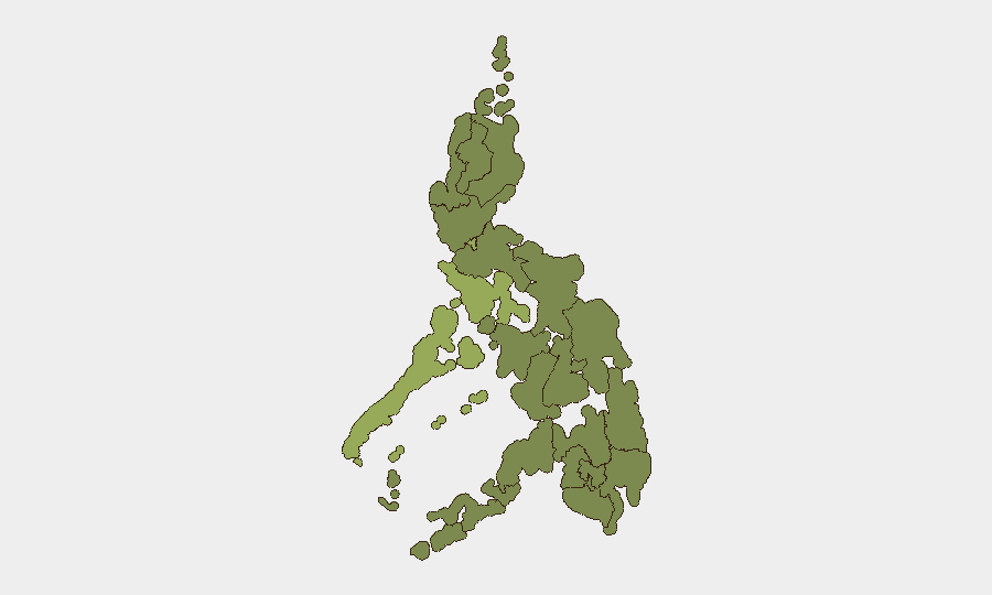
Metro Manila dominates the risk landscape at 55.7, driven by population density, critical infrastructure concentration, and organized crime presence. Mimaropa (44.8) and the Cordillera Administrative Region (39.3) follow, reflecting criminal networks, mining-sector tensions, and insurgent activity in remote zones. Zamboanga Peninsula (28.4) remains elevated due to persistent maritime piracy and kidnapping-for-ransom risk, while Bangsamoro and Caraga regions (both 25.7) reflect residual extremist and criminal networks. Operations in Metro Manila require the most stringent duty-of-care protocols; travel to Mindanao regions should incorporate security briefings and armed-escort protocols where operationally appropriate.
How GeoBit Would Assist
Teams with people or assets in the Philippines should employ AOI Monitoring & Early Warning to track Metro Manila, Mindanao corridors, and maritime zones for incident escalation in near real-time. Conflict & Military and Network & Actor Analysis capabilities enable mapping of criminal and insurgent actors, while Maritime & Aviation Tracking and Satellite & Imagery Analysis support supply-chain and facility risk assessment. Concurrent use of OSINT Fusion & Corroboration (X/Telegram, local media, official PNP/AFP statements) ensures corporate security teams access verified incident data without reliance on rumor or delayed public reporting.
7-Day Outlook
Diplomatic tensions with the ICC are unlikely to produce acute security incidents but may create operational friction (visa delays, legal uncertainty for some staff). Earthquake aftershock risk remains elevated in Mindanao and eastern Luzon; infrastructure and transport disruptions should be anticipated. Routine organized-crime and insurgent activity in high-risk zones will continue; no major escalation is forecast, but the next 7 days will clarify whether the recent diplomatic rhetoric translates into policy changes affecting corporate operations.
Highest-Risk Areas — Ranked
| # | State / Region | Risk |
|---|---|---|
| 1 | Metro Manila | 55.7 |
| 2 | Mimaropa | 44.8 |
| 3 | Cordillera Administrative Region | 39.3 |
| 4 | Zamboanga Peninsula | 28.4 |
| 5 | Bangsamoro | 25.7 |
| 6 | Caraga | 25.7 |
| 7 | Northern Mindanao | 25.7 |
| 8 | Soccsksargen | 25.7 |
| 9 | Davao Region | 25.7 |
| 10 | Ilocos Region | 25.7 |
| 11 | Cagayan Valley | 25.7 |
| 12 | Central Luzon | 25.7 |
Sources
Previous Daily Briefs
A new Philippines brief is written every day — each with its own risk map and downloadable CSV. Here's the last week; use the calendar to go further back.
📅 Browse every day by calendar →
Highlighted days have a brief. Tap a day for that day's map & analysis, or “csv” for that day's dataset ($5).