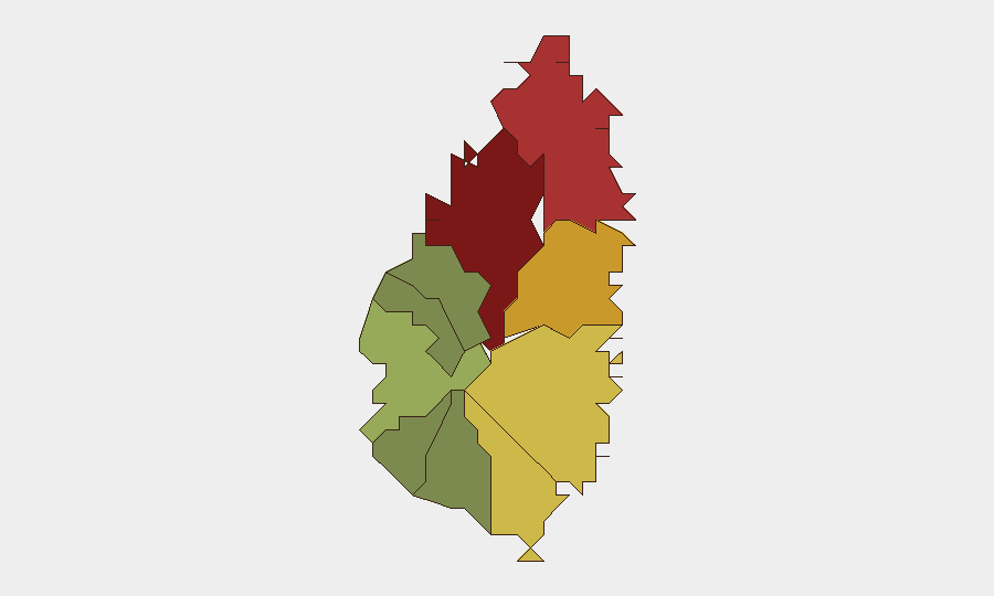
Situation Summary
Saint Lucia remains at moderate composite risk (global rank #155, score 6/100) but faces elevated interpersonal and firearms violence concentrated in the capital and adjoining districts. The island has recorded 45 homicides through mid-August 2026—73% involving firearms—establishing a trajectory consistent with prior-year trends. Two fatal shootings and one serious assault occurred in Castries and nearby areas on 16 August; an ongoing villa invasion case involving US nationals was resolved with four arrests on 20–21 August. The security picture is not deteriorating rapidly, but violence remains endemic to specific high-density zones and continues to pose duty-of-care risks to corporate personnel and foreign visitors.
Key Developments
- Castries, Belair & Ravine Chabot (16 August, updates through 24 August): Two fatal shootings under active police investigation. Jamal Thomas (25) killed in Belair; John "Slade" Ferdinand (56) killed in Ravine Chabot. Royal Saint Lucia Police Force Major Crimes Unit is pursuing leads; no suspects publicly identified. Police appeals for information remain active as of 24 August.
- Babonneau, near Babonneau Police Station (16 August, update 23 August): J'ouvert community event descended into violent altercation; victim struck on head with apparent rock and hospitalized with concussion. Four men fled scene. Victim reported in stable condition; investigation ongoing with no arrests announced as of 23 August.
- Rodney Bay, Gros Islet (ongoing, update 23 August): Fresh police briefing (21 August, updated 23 August) on Tenisha Yarde fatality (died 10 August following 2 August altercation and omnibus strike). Person of interest detained and released pending Director of Public Prosecutions guidance. Case remains under active legal review in key tourism district.
- Savannes Bay villa invasion (27 July incident, charges announced 20–21 August, updated through 24 August): Four individuals formally charged in July villa invasion targeting three US nationals. Case frames foreign-visitor security as active enforcement priority; video briefings and police announcements circulated through 24 August.
- Island-wide homicide and firearms briefing (19–20 August, updated through 24 August): Royal Saint Lucia Police Force reports 45 confirmed homicides (all murders) from 1 January to 18 August 2026; 73% firearm-involved. Record firearm seizures noted. Total reported crimes island-wide: 8,776. Briefing indicates sustained high-violence environment.
Highest-Risk Areas
Castries (risk 95) and Gros Islet (risk 78) together account for nearly 40% of sub-national threat concentration. Castries—the capital—hosts government, financial services, and tourism infrastructure; recent fatal shootings in Belair and Ravine Chabot reflect ongoing gang-affiliated and interpersonal homicide clusters. Gros Islet, the northern tourism and nightlife hub, remains under investigation for the Rodney Bay fatal altercation. Secondary risk zones (Dennery, Vieux Fort, Micoud) show sustained but lower intensity. Southern and western districts (Soufrière, Laborie, Choiseul, Anse La Raye, Canaries) register significantly lower composite risk, suggesting violence is geographically concentrated in commercial and densely populated corridors.
How GeoBit Would Assist
Corporate security teams should deploy AOI Monitoring & Early Warning on Castries, Gros Islet, and Dennery to detect emerging hotspots and alert duty-of-care managers to personnel proximity. OSINT Fusion & Corroboration across local news, police briefings, and social media will provide real-time incident tracking and motive analysis. Routing & Network Analysis enables security staff to plan alternative transport corridors avoiding high-risk districts during peak violence windows (typically evening/night hours in capital zones).
7-Day Outlook
No imminent escalation signals are evident; violence patterns remain consistent with endemic gang-related and interpersonal homicide cycles. Police enforcement (villa case charges, ongoing major crimes investigations) suggests institutional response capacity. Monitoring of court outcomes, gang communication channels, and police briefing cadence will be critical to detect any shift in violence intensity or geographic spread into lower-risk zones.
Highest-Risk Areas — Ranked
| # | State / Region | Risk |
|---|---|---|
| 1 | Castries | 95 |
| 2 | Gros Islet | 78 |
| 3 | Dennery | 72 |
| 4 | Vieux Fort | 68 |
| 5 | Micoud | 65 |
| 6 | Soufrière | 42 |
| 7 | Laborie | 38 |
| 8 | Choiseul | 35 |
| 9 | Anse La Raye | 28 |
| 10 | Canaries | 12 |
Sources
Previous Daily Briefs
A new Saint Lucia brief is written every day — each with its own risk map and downloadable CSV. Here's the last week; use the calendar to go further back.
- August 22, 2026
- August 20, 2026
- August 18, 2026
- August 16, 2026
- August 14, 2026
- August 12, 2026
- August 10, 2026
📅 Browse every day by calendar →
Highlighted days have a brief. Tap a day for that day's map & analysis, or “csv” for that day's dataset ($5).
Atlas — our AI intelligence desk — emails them this snapshot personally. Nothing else, no list.