Situation Summary
Solomon Islands remains a low-intensity, chronically fragile state with composite threat score 7/100 and no major active conflict. Security posture is shaped by historical post-conflict residue (unexploded ordnance across Western and Choiseul provinces), limited state capacity, and strategic competition between China and Australia over influence and maritime security. Current trajectory is stabilization through targeted capacity-building (maritime policing, border infrastructure) and ordnance remediation rather than escalation or civil unrest.
Key Developments
- Western Province – UXO disposal operations ongoing (15–27 August). RSIPF Explosive Ordnance Disposal Department conducting daily planned bomb-blast demolitions 08:00–16:00 across Munda, Rendova, and Kolombangara Islands. Residents warned to avoid affected zones during working hours; no unplanned incidents reported.
- Choiseul Province – UXO disposal operations scheduled (19–24 August). RSIPF EOD advisory issued 15 August for planned demolitions in Tarekukure, Taro, and surrounding communities. Public advised to report additional UXO sightings and maintain distance from active demolition sites.
- Shortland Islands – Western Border Outpost opening (16–17 August). Australian Deputy Prime Minister and Defence Minister scheduled to visit and formally open new border-security facility on 16–17 August. Outpost designed to enhance maritime surveillance and cross-border law enforcement cooperation with Papua New Guinea.
- Honiara – high-level defence and security consultations (16–17 August). Australian Deputy PM/Defence Minister to meet Prime Minister Matthew Wale and senior cabinet members to discuss defence cooperation and regional security strategy. Represents continuation of Australian-Solomon Islands strategic alignment.
- National – China security agreement under review (ongoing). Government publicly reaffirming transparency review of 2022 bilateral security pact with China; reflects political-security repositioning rather than immediate instability but signals ongoing strategic recalibration.
- Maritime domain – enhanced policing capacity (14–15 August announcement). RSIPF received two Naiad patrol vessels from Australian Federal Police under AUD 6.5 million regional maritime security program. Improves sustained patrol capability in exclusive economic zone and coastal waters.
Highest-Risk Areas
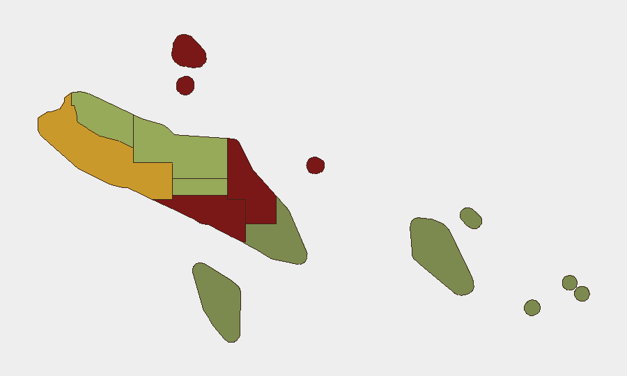
Honiara (risk 92) and Guadalcanal (risk 88) drive national risk score, driven by urbanization, informal settlements, limited police presence, and historical communal tensions. Malaita (risk 85) reflects similar structural challenges plus legacy resource grievances. Western Province (risk 72)—despite planned UXO operations—carries residual unexploded ordnance hazard and geographic remoteness that complicates rapid state response. All other provinces score below 60, indicating risk concentration in the capital and surrounding/eastern regions.
How GeoBit Would Assist
Corporate security teams with personnel or assets in Solomon Islands should employ AOI Monitoring & Early Warning for Honiara, Guadalcanal, and Malaita to track social tension, protest activity, and crime-cluster emergence in real time. Satellite & Imagery analysis and GIS & Spatial Analysis enable pinpointing of UXO-remediation zones and cordoned areas (Western, Choiseul) to support route planning and movement authorization. Multi-language OSINT and social-media sentiment analysis on local Pidgin, Bislama, and English feeds provide early signal of unrest or public safety incidents before mainstream reporting.
7-Day Outlook
UXO disposal operations will continue as scheduled through 24–27 August across Western and Choiseul provinces, with localized movement restrictions but no anticipated conflict. Australian ministerial visit and border-outpost opening on 16–17 August represent stability-reinforcing diplomatic moves; no countervailing political or security flashpoints are evident. Risk trajectory remains flat to slightly declining if ordnance remediation proceeds without incident.
Highest-Risk Areas — Ranked
| # | State / Region | Risk |
|---|---|---|
| 1 | Honiara | 92 |
| 2 | Guadalcanal | 88 |
| 3 | Malaita | 85 |
| 4 | Western | 72 |
| 5 | Choiseul | 58 |
| 6 | Isabel | 52 |
| 7 | Central Province | 48 |
| 8 | Makira-Ulawa | 38 |
| 9 | Rennell and Bellona | 22 |
| 10 | Temotu | 18 |
Sources
Previous Daily Briefs
A new Solomon Islands brief is written every day — each with its own risk map and downloadable CSV. Here's the last week; use the calendar to go further back.
- August 14, 2026
- August 12, 2026
- August 10, 2026
- August 8, 2026
- August 6, 2026
- August 5, 2026
- August 4, 2026
📅 Browse every day by calendar →
Highlighted days have a brief. Tap a day for that day's map & analysis, or “csv” for that day's dataset ($5).
Atlas — our AI intelligence desk — emails them this snapshot personally. Nothing else, no list.