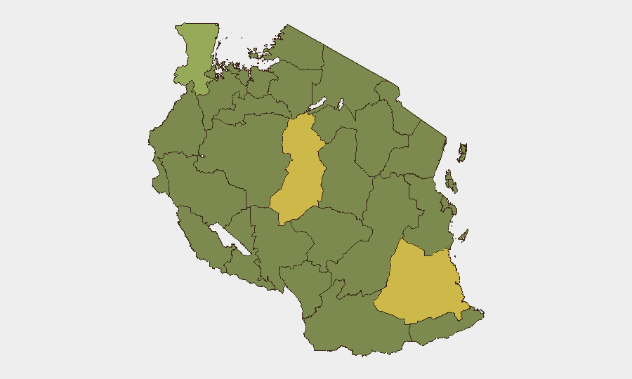
Situation Summary
Tanzania remains a moderate, steady-state security environment (global rank #47; composite threat score 45) with no acute national crisis. Wildfire activity has been elevated in recent days across multiple regions, though these are environmental rather than conflict-driven hazards. Diplomatic engagement with Western partners continues normally, including high-level visits and health cooperation agreements. The security trajectory is stable with localized environmental and cross-border concerns concentrated in northwestern and southern regions.
Key Developments
- Wildfire incidents (recent, multi-region). GeoBit has tracked four separate wildfire events across Tanzania (IDs 1029182, 1029157, 1029217, 1029122) within the last reporting cycle. These pose risks to transportation routes, air quality, and rural communities, particularly in fire-prone regions. Specific locations and containment status require confirmation from Tanzanian disaster-management authorities.
- U.S.–Tanzania diplomatic activity (July 2–4). President Daniel Chapo completed a three-day official visit, and a new bilateral health memorandum of understanding was signed. No security incidents or disruptions to this engagement have been reported; activity is routine inter-government cooperation.
- Multi-party diplomatic tensions (July 1). GeoBit event signals captured three "reject" interactions between Tanzania and Russian Federation actors, and two "reject" signals between Tanzania and the United States, alongside public statements from both Western and Russian parties. The nature and substance of these rejections remain unclear from available reporting; they likely reflect diplomatic posturing rather than escalation.
- Myanmar-related public statement (July 1). A public statement attributed to Myanmar appeared in the same signal cluster as Tanzania–Russia/U.S. interactions. Relevance to Tanzania's internal security is minimal unless Myanmar-Tanzania defense or trade matters are involved.
Highest-Risk Areas
Singida and Lindi regions drive the highest composite risk scores (61.8 each), followed by Kagera (46.8) in the northwest near the Uganda/Rwanda border. Singida's elevated score likely reflects a combination of land-use disputes, pastoralist-farmer tensions, and cross-border livestock trafficking that have been documented in prior months. Lindi, in the south, carries risk from maritime crime, poaching networks, and contraband flows associated with its port proximity and border with Mozambique. Kagera's risk profile is anchored in persistent cross-border instability from Uganda and Rwanda, including refugee flows and irregular migration. The remaining northern and western regions (Kigoma, Mwanza, Geita, Tabora, Katavi, Rukwa, Mara, and Songwe) all score 31.8, indicating moderate, chronic vulnerabilities rather than acute threats.
How GeoBit Would Assist
Teams with personnel or assets in Tanzania should employ AOI Monitoring & Early Warning on Singida, Lindi, and Kagera to detect upticks in cross-border movement, demonstrations, or security incidents in near-real time. Conflict & Military mapping combined with Network & Actor Analysis would clarify the diplomatic signals on July 1 and their implications for foreign nationals. Environmental & Health monitoring via satellite imagery and event feeds should track wildfire progression and humanitarian impact, informing duty-of-care decisions around travel and operations in fire-affected zones.
7-Day Outlook
No major escalation is anticipated over the next week. Wildfire activity may persist depending on weather patterns, but remains manageable within Tanzania's disaster-response capacity. Diplomatic tensions between Tanzania and Western/Russian actors are rhetorical rather than operationally concerning and are unlikely to trigger sudden restrictions on foreign business or travel.
Highest-Risk Areas — Ranked
| # | State / Region | Risk |
|---|---|---|
| 1 | Singida Region | 61.8 |
| 2 | Lindi Region | 61.8 |
| 3 | Kagera | 46.8 |
| 4 | Kigoma Region | 31.8 |
| 5 | Mwanza Region | 31.8 |
| 6 | Geita | 31.8 |
| 7 | Shinyanga Region | 31.8 |
| 8 | Tabora Region | 31.8 |
| 9 | Katavi Region | 31.8 |
| 10 | Rukwa Region | 31.8 |
| 11 | Songwe Region | 31.8 |
| 12 | Mara Region | 31.8 |
Previous Daily Briefs
A new Tanzania brief is written every day — each with its own risk map and downloadable CSV. Here's the last week; use the calendar to go further back.
📅 Browse every day by calendar →
Highlighted days have a brief. Tap a day for that day's map & analysis, or “csv” for that day's dataset ($5).