Situation Summary
Togo remains a low-to-moderate security concern globally (rank #81, composite threat score 19), with terrorism and insurgency as the primary drivers, though 0 tracked active events are currently reported. The country's threat profile is heavily concentrated in the northern Savanes and Kara regions, where cross-border activity and weapons proliferation remain concerns; southern and maritime zones present significantly lower risk. Recent activity signals focus on crime (burglary networks), infrastructure resilience (power grid faults from Ghana), and continued state enforcement operations (mass firearm destruction), indicating a security environment characterized more by petty crime and administrative capacity-building than by active conflict or organized terrorism at present.
Key Developments
- Kpogan — 2026-08-08 — Gendarmerie nationale arrested three suspected members of a burglary network linked to a break-in at the MATW Islamic center; two additional suspects remain at large. This reflects localized property crime rather than organized or politically motivated violence.
- Multiple localities nationwide — 2026-08-08 — The national power utility (CEET) attributed electricity disruptions across several areas to a fault on Ghana's power network occurring at 03:10. While not a security incident per se, such infrastructure events can degrade response capability and affect duty-of-care logistics in affected zones.
- Agoè-Nyivé, Lomé — 2026-08-08 — Authorities completed public destruction of approximately 1,000 illicit or obsolete firearms as part of anti-crime and arms-control operations, signaling sustained state enforcement of weapons proliferation controls.
Highest-Risk Areas
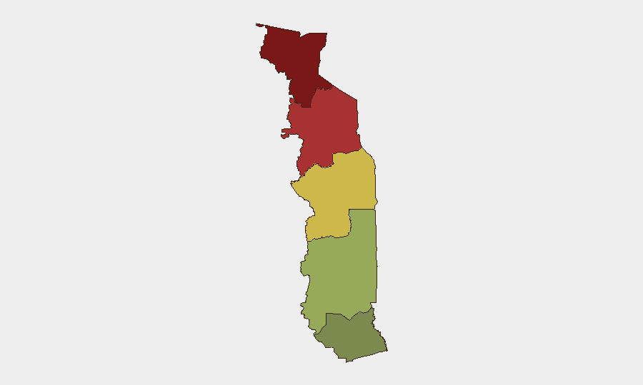
The Savanes Region (risk score 92) and Kara Region (risk score 78) account for the majority of Togo's national threat concentration, driven principally by proximity to Burkina Faso and Mali (both experiencing active insurgency), historical weapons trafficking networks, and limited state administrative capacity in remote border zones. The Centrale Region (score 65) presents secondary risk, likely reflecting spillover activity and transit routes. Conversely, the Maritime Region (score 28) and most of Plateaux (score 45) remain substantially lower-risk, with Lomé and coastal zones suitable for standard corporate security protocols. Organizations with operations or personnel in the north should prioritize border-zone monitoring and movement restrictions; southern-based activities face primarily conventional crime and petty corruption rather than organized violence.
How GeoBit Would Assist
Security and risk teams monitoring Togo should employ AOI (Area-of-Interest) Monitoring & Early Warning on the Savanes and Kara regions to detect cross-border militant or trafficking activity before it escalates; Intel Sweep and multi-language OSINT (particularly French and local-language sources) to track weapons proliferation, gendarme corruption, and organized crime networks; and Routing & Network Analysis to identify safe transit corridors and identify checkpoints or extortion-prone roads (such as the Gbatope-Davedi section, where racketeering has been reported). Real-time conflict and terrorism search capabilities can also surface emerging group activity or recruitment signals in real time.
7-Day Outlook
No imminent escalation is anticipated. Security operations are likely to remain characterized by routine law enforcement (arrests, asset destruction) and border monitoring. However, the northern regions warrant continued watch for cross-border spillover from Burkina Faso or Mali; any significant uptick in weapons trafficking or militant incursions could rapidly elevate threat status. Personnel movement in Savanes and Kara should remain subject to heightened travel controls and vetting protocols.
Highest-Risk Areas — Ranked
| # | State / Region | Risk |
|---|---|---|
| 1 | Savanes Region | 92 |
| 2 | Kara Region | 78 |
| 3 | Centrale Region | 65 |
| 4 | Plateaux Region | 45 |
| 5 | Maritime Region | 28 |
Sources
Previous Daily Briefs
A new Togo brief is written every day — each with its own risk map and downloadable CSV. Here's the last week; use the calendar to go further back.
📅 Browse every day by calendar →
Highlighted days have a brief. Tap a day for that day's map & analysis, or “csv” for that day's dataset ($5).
Atlas — our AI intelligence desk — emails them this snapshot personally. Nothing else, no list.