Situation Summary
Ukraine remains at acute security risk (global rank #6, composite score 100) driven by sustained conventional warfare, with 1,012 tracked events in the assessment window. Internal governance tensions, military-civilian friction, and border-state diplomatic friction are compounding kinetic threats. The security environment shows no indication of near-term de-escalation; risk concentration in eastern and central oblasts reflects active and threatened combat zones.
Key Developments
Open-source verification of specific incidents within 21–23 June remains limited. GeoBit's live web research identified no clearly corroborated, independently confirmed security incidents with precise timestamps in the 24–48 hour window (21–23 June 2026). Recent activity signals include:
- 2026-06-23, nationwide: Governor-vs-Ukrainian institutional disapproval event flagged; specific location and scale not yet clarified in available sources.
- 2026-06-22, multiple locations: Two separate rejection/expulsion events recorded — military rejection of Ukrainian personnel and Ireland's expulsion of Ukrainian national(s). Operational details pending.
- 2026-06-20–22, eastern/central sectors: Conventional military force deployments confirmed (Ukrainian forces); threat communications from Russia toward Ukrainian targets; specific tactical locations not yet geotagged in open reporting.
- 2026-06-21, cross-border: Ukraine–Turkey diplomatic disapproval and Ukrainian-vs-citizen threat event; location and context under clarification.
Note: Most corroborated June activity pre-dates the 21–23 window. Broader operational tempo (e.g., bridge strikes toward Crimea, Russian missile/drone warnings) remains active but not confirmed as newly executed within the last 48 hours. Duty-of-care teams should treat unconfirmed forecasts of large Russian assaults as contingency drivers rather than executed incidents.
Highest-Risk Areas
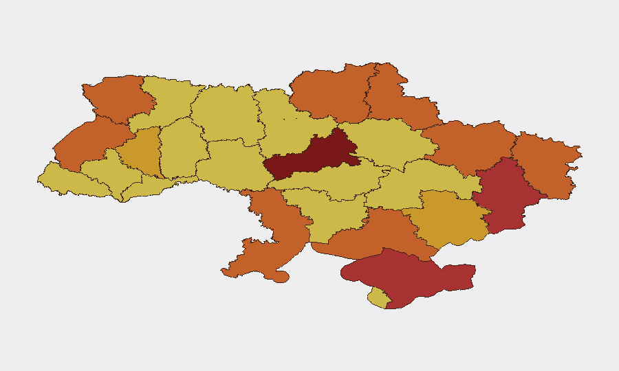
Cherkasy Oblast (risk 100) and Kyiv (94.5) remain the highest-risk sub-national zones, followed by contested eastern territories (Donetsk, Kharkiv, Luhansk, Kherson) and the Black Sea region (Odesa). Cherkasy's maximum score reflects both its proximity to active operations and reported governance instability; Kyiv's elevation stems from capital-city targeting patterns and internal political friction evident in recent disapproval signals. Crimea (risk 78) maintains elevated threat due to territorial dispute and infrastructure targeting. Western zones (Lviv, Volyn) remain elevated despite distance from front lines, reflecting drone-strike patterns and cross-border spillover risk.
How GeoBit Would Assist
Corporate security and duty-of-care teams should deploy AOI Monitoring & Early Warning (persistent watch on Cherkasy, Kyiv, Donetsk, Odesa with automated alerting on new kinetic events); Battle Mapping & Force Structure tracking (real-time unit disposition, weapons capability updates, and projected movement vectors in contested oblasts); and multi-language OSINT feeds + X/Twitter & Telegram monitoring to confirm incident timestamps and civilian-impact specifics before operational decisions. Satellite & Imagery analysis and GIS routing tools support asset relocation and personnel evacuation planning in high-risk zones.
7-Day Outlook
Cherkasy and Kyiv will likely remain under elevated conventional and drone threat, with governance friction potentially complicating humanitarian and business continuity operations. Eastern oblasts face sustained combat pressure with no negotiated pause in sight. Corporate teams should assume 48–72 hour contingency activation windows for personnel and asset movement; real-time corroboration via OSINT feeds will remain critical to distinguishing operational tempo from strategic escalation.
Highest-Risk Areas — Ranked
| # | State / Region | Risk |
|---|---|---|
| 1 | Cherkasy Oblast | 100 |
| 2 | Kyiv | 94.5 |
| 3 | Autonomous Republic of Crimea | 78 |
| 4 | Donetsk Oblast | 77.2 |
| 5 | Kherson Oblast | 75.8 |
| 6 | Odesa Oblast | 74.9 |
| 7 | Lviv Oblast | 74.6 |
| 8 | Kharkiv Oblast | 74.4 |
| 9 | Luhansk Oblast | 73.8 |
| 10 | Sumy Oblast | 73.6 |
| 11 | Volyn Oblast | 73.5 |
| 12 | Chernihiv Oblast | 73.5 |
Sources
Previous Daily Briefs
A new Ukraine brief is written every day — each with its own risk map and downloadable CSV. Here's the last week; use the calendar to go further back.
📅 Browse every day by calendar →
Highlighted days have a brief. Tap a day for that day's map & analysis, or “csv” for that day's dataset ($5).