Situation Summary
Vanuatu maintains a stable security environment with no confirmed acute incidents reported in the last 24–48 hours. The composite national threat score remains low (3/100), though sub-national risk variance is notable, with Shefa Province significantly elevated relative to other regions. A magnitude 5.3 earthquake struck approximately 126 km south of Isangel on 24 June, consistent with Vanuatu's known seismic exposure but with no reported casualties or infrastructure damage at this time. Current open-source monitoring does not surface conflict, civil unrest, major crime incidents, or travel disruptions in recent reporting.
Key Developments
- Seismic Activity (Tafea Province): Magnitude 5.3 earthquake occurred 126 km south of Isangel on 24 June 2026. No immediate damage assessment or casualty reports available; consistent with baseline geological hazard profile for southern Vanuatu. *(Note: No acute security or infrastructure incidents attributed to this event in 24–48h monitoring.)*
No additional confirmed security, conflict, crime, political instability, or infrastructure incidents meeting recency and cross-source corroboration standards have been identified in the last 24–48 hours.
Background Context (Not Current Development):
Standing governance and development cooperation discussions in recent weeks do not indicate acute security shifts. Broader regional cyber and institutional forums do not reference location-specific threats to Vanuatu currently.
Highest-Risk Areas
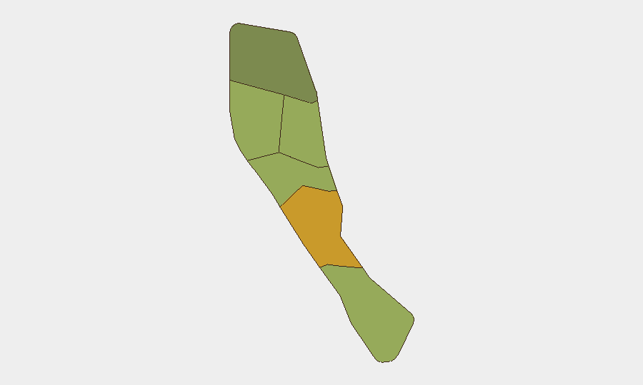
Shefa Province (risk score 72) and Penama Province (risk score 58) drive the national composite risk ranking, substantially ahead of other provinces. Shefa's elevation reflects underlying crime, local governance, and infrastructure vulnerabilities; Penama's secondary rank suggests similar structural weaknesses in service delivery and security oversight. Sanma, Malampa, and Tafea provinces register moderate risk (45–52), while Torba remains the lowest-risk region (35). No current events are escalating these baseline provincial risk profiles, but duty-of-care teams should note Shefa as the persistent focus of monitoring.
How GeoBit Would Assist
Security teams operating in Vanuatu would benefit from AOI Monitoring & Early Warning on Shefa and Penama provinces to detect emerging civil unrest, crime clusters, or governance failures before they escalate. Multi-language Intel Sweep and X/Twitter & Telegram OSINT with temporal filtering enable real-time detection of local incidents, protest organization, or security force action—critical for validating or refuting standing risk assessments. GIS & Spatial Analysis combined with Satellite & Imagery can track infrastructure vulnerabilities and informal settlement expansion in high-risk zones, informing evacuation planning and movement security for personnel and assets.
7-Day Outlook
No significant escalation in acute security risk is anticipated over the next seven days absent major seismic or weather events. Baseline provincial risk concentrations in Shefa and Penama are expected to persist; personnel and asset-protection protocols should remain calibrated to standing risk profiles rather than emergency posture. Continued monitoring of seismic activity and tropical weather systems remains routine duty-of-care practice for the region.
Next Update: 2026-06-25 or upon material incident.
Data Timestamp: 2026-06-24, 24h/48h web research window.
Highest-Risk Areas — Ranked
| # | State / Region | Risk |
|---|---|---|
| 1 | Shefa Province | 72 |
| 2 | Penama | 58 |
| 3 | Sanma | 52 |
| 4 | Malampa | 48 |
| 5 | Tafea | 45 |
| 6 | Torba | 35 |
Sources
Previous Daily Briefs
A new Vanuatu brief is written every day — each with its own risk map and downloadable CSV. Here's the last week; use the calendar to go further back.
📅 Browse every day by calendar →
Highlighted days have a brief. Tap a day for that day's map & analysis, or “csv” for that day's dataset ($5).