GeoBit Mobile · iOS & Android

The desk's picture,
in the field's pocket.

GeoBit Mobile is the field app for the platform. Every layer, route and order the analyst pushes lands on the phone as a map, not a message. Position, photos, tags and acknowledgements go back the other way. Encrypted end to end, works offline, and runs on any GeoBit server — ours, yours or a customer-hosted instance.

iOS + Android
one app, any server
Encrypted
end to end · Signal-protocol comms
Offline
map packs + queued sync
What it is

Built for the person who is actually there.
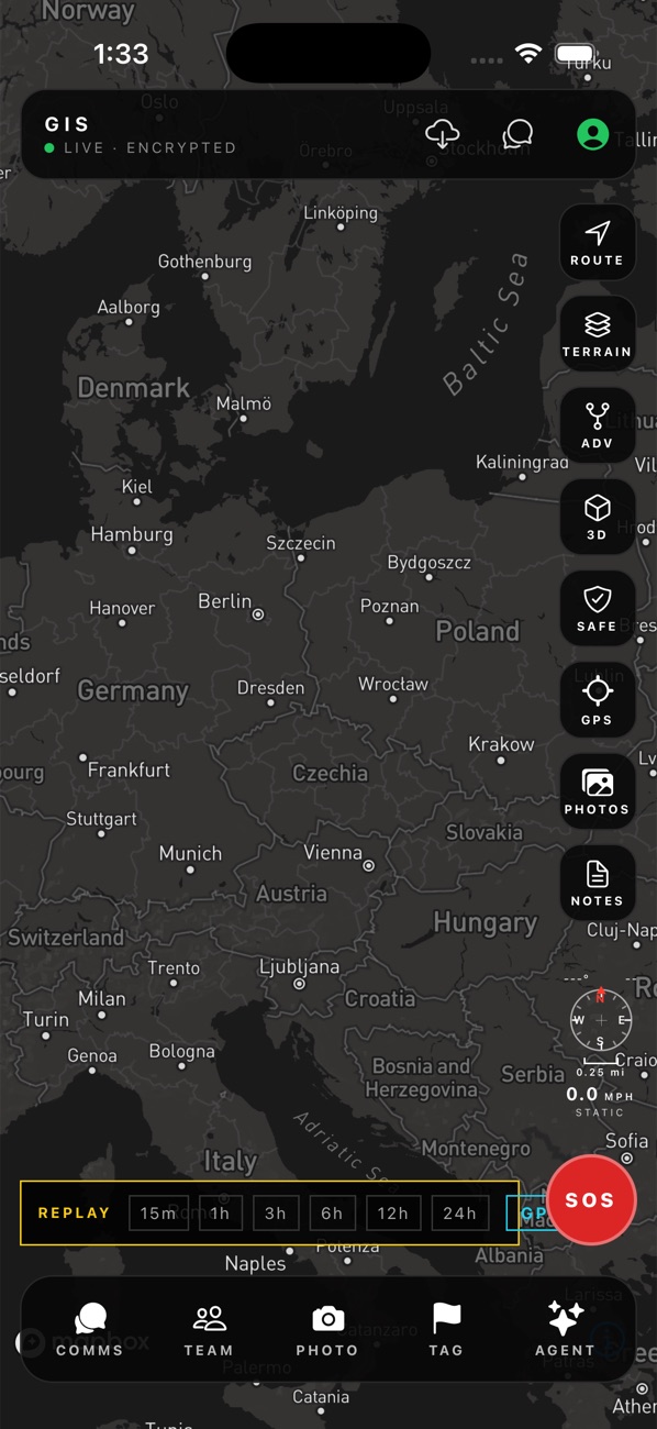
GeoBit Mobile on iPhone: live encrypted session with Route, Terrain, ADV, 3D, Safe, GPS, Photos and Notes tools, GPS replay bar, SOS, and the Comms, Team, Photo, Tag and Agent dock
GeoBit Mobile · iPhone · live, encrypted session

The app is one screen: the map, the tools on the right, the team dock at the bottom, SOS where a thumb finds it. Nothing to learn on the day it matters.

Routes & terrain

Walk or drive routes with steepness labels, least-cost paths, high points, route deviation alerts and a 3D terrain view.

Live position

Background GPS with heading, speed and a 24-hour replay scrubber; GPX export; battery-aware.

SOS & safe

Panic escalates to the desk and the org channel with your position; safe locations and isochrones on tap.

Comms & calls

Encrypted messaging, voice and video calls, voice mail and photo sharing in the same thread as the map.

Photos, notes, tags

Geo-tagged photos and notes pinned to the map; field tags that appear on the desk instantly.

Team

See your team live, geofence alerts, orders with routes, plans and after-action logs.

Offline

Downloadable map packs; everything you do in a dead spot queues and syncs when signal returns.

Agent

Ask the GeoBit agent from the phone — the same chat-to-map brain as the desk, on-device model for the basics.

Desk to phone and back

Two-way sync, not a viewer.

01

Analyst builds

A route, a threat surface, an AOI, a task — built on the desktop in plain language.

02

Push

Send to one person, a group or the whole org. Whole map with one shortcut. It arrives as layers on the phone.

03

Field acts

The driver follows the route, tags what they see, takes a photo, acknowledges the order.

04

Desk sees it

Position, photo, tag and ack land on the desk picture within seconds. All of it logged.

Security

Encrypted end to end. Yours to host.

Messages, calls, photos and voice mail use the Signal protocol (X3DH + double ratchet) with per-device keys, group sessions and safety-number fingerprints. The server relays ciphertext; it cannot read it.

The app pairs with any GeoBit server by URL or QR — gis.geobit.ai, a regional instance, your own private deployment or an air-gapped network. Multi-device: sign in on a second phone and the history syncs; retire a lost device from the desk.

Position sharing is explicit and per-session, with a public mode for anonymous crowd reporting when you need it.

Field seat

For the people on the ground

  • GeoBit Mobile on iOS and Android
  • Receives layers, routes, orders and plans
  • Live position, SOS, geofence alerts
  • end-to-end encrypted comms, calls, photos, notes, tags
  • Offline map packs and queued sync
Bundled with analyst seats in the Ops Desk. Volume pricing above 50 field seats.
Related

Where the app fits.

Put GeoBit Mobile on your team's phones.

Tell us how many people and which platform. We send the install links and pair the app to your GeoBit instance.

— or —
Book a call directly
Or call us now: +1 (202) 972-1938
EnglishEspañolPortuguêsFrançaisالعربيةעברית日本語