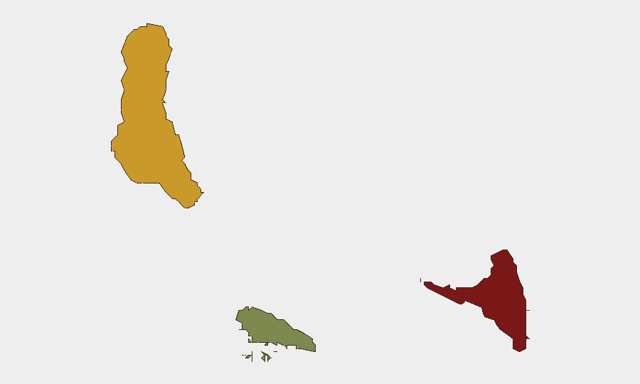
Situation Summary
Comoros remains a low-frequency threat environment globally (rank #129, composite score 7), with no discrete security incidents recorded in the current reporting window. The archipelago's risk profile is geographically concentrated in Anjouan and Grande Comore, where historical drivers—including competition for political control, weak state capacity, and maritime vulnerability—sustain elevated baseline risk. No active civil unrest, crime surges, infrastructure failures, or travel disruptions have been confirmed in the last 24–48 hours.
Key Developments
No verifiable security, political, civil-unrest, or infrastructure incidents in Comoros were confirmed in the last 24–48 hours across open media, social platforms, or official channels. A July 5, 2026 diplomatic post from Indian Foreign Minister S. Jaishankar acknowledged a national occasion in Comoros but contained no security or stability references. Absence of reportage does not indicate absence of risk; it reflects a period of operational quiet in a chronically under-reported theater.
Highest-Risk Areas
Anjouan (risk score 88) remains the primary focal point, historically driven by separatist sentiment, weak governance integration, and occasional competition for administrative control with the federal center. Grande Comore (risk score 72) concentrates national-level political and security apparatus, including law enforcement and port infrastructure, and thus remains vulnerable to political instability and organized maritime activity. Moheli (risk score 35) carries substantially lower risk and functions as a secondary concern. The gradient reflects both institutional fragility in the outer islands and the concentration of state capacity—and contestation—on the largest island.
How GeoBit Would Assist
Teams with personnel or assets in Comoros should leverage AOI (Area-of-Interest) Monitoring & Early Warning on Anjouan and Grande Comore to detect emerging protest activity, political announcements, or security-force movements before they escalate. Multi-language OSINT & X/Telegram monitoring of Comorian political and civil-society accounts, combined with regional maritime and aviation tracking, would provide early signals of port disruptions, official travel, or cross-island tensions. Regime-stability and border-dispute search capabilities can contextualize any future political friction with the federal government or neighboring Indian Ocean actors.
7-Day Outlook
No near-term triggers for acute deterioration are evident. Comoros is expected to remain in a low-incident posture over the next 7 days, barring unannounced political developments or maritime security incidents in the Mozambique Channel. Organizations should maintain standing monitoring of Anjouan and monitor official government communications for any fiscal, electoral, or administrative announcements that could signal renewed separatist or inter-island tension.
GEOBIT RECOMMENDATION: For organizations with sustained operations in Comoros, activate persistent AOI monitoring on Moroni (Grande Comore) and Mutsamudu (Anjouan) with 48-hour alert escalation; confirm duty-of-care protocols for maritime and inter-island travel. Standard precautions remain appropriate; no emergency posture change is warranted at this time.
Highest-Risk Areas — Ranked
| # | State / Region | Risk |
|---|---|---|
| 1 | Anjouan | 88 |
| 2 | Grande Comore | 72 |
| 3 | Moheli | 35 |
Sources
Previous Daily Briefs
A new Comoros brief is written every day — each with its own risk map and downloadable CSV. Here's the last week; use the calendar to go further back.
📅 Browse every day by calendar →
Highlighted days have a brief. Tap a day for that day's map & analysis, or “csv” for that day's dataset ($5).
Atlas — our AI intelligence desk — emails them this snapshot personally. Nothing else, no list.