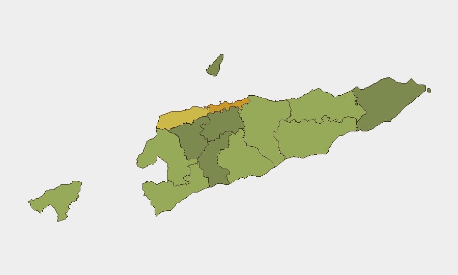
Situation Summary
East Timor remains a low-threat environment with a composite threat score of 3 globally (#189 ranked) and no confirmed security incidents in the past 24–48 hours. The country shows broad stability across political, civil, and infrastructure domains, with current open-source reporting dominated by diplomatic engagement and economic cooperation rather than unrest, violence, or acute crime spikes. Risk concentration remains heavily weighted toward the capital, Dili, and surrounding municipalities, while most rural and eastern regions maintain substantially lower incident profiles.
Key Developments
No discrete security, conflict, civil unrest, major crime, or infrastructure incidents meeting verification and recency standards (last 24–48 hours, multiple credible sources) are currently identified for East Timor.
Recent reporting in the same window focuses on diplomatic visits and official economic cooperation engagements rather than threat-level developments.
Highest-Risk Areas
Dili (risk 72) accounts for the majority of documented national risk and reflects its role as capital, primary commercial hub, and concentration point for government, diplomatic, and international personnel. Liquiçá (62) and Baucau (58) follow at significant distance, suggesting that inter-communal tensions, localized gang activity, or border-adjacent pressures in these municipalities warrant monitoring but remain substantially lower-incident than the capital. Western border municipalities (Cova Lima, Bobonaro, Oecussi-Ambeno) score moderately (55–48) and may reflect historical cross-border movement concerns or informal trade dynamics; eastern and central regions (Viqueque, Manufahi, Aileu, Ermera) score below 45 and show minimal acute risk signals. The steep risk gradient from Dili to all other regions indicates that corporate and expatriate duty-of-care focus should prioritize the capital, with standard baseline precautions sufficient for most provincial deployments.
How GeoBit Would Assist
For ongoing East Timor monitoring, security teams would deploy AOI (Area-of-Interest) Monitoring & Early Warning on Dili, Liquiçá, and Baucau to detect emerging unrest, crime clustering, or civil tension in near-real time; Multi-Language OSINT (X/Twitter, Telegram, local news feeds, and social sentiment analysis) to track political rhetoric, community sentiment shifts, and grassroots threat signals; and Network & Actor Analysis to map criminal organizations, gang affiliations, and conflict-prone communities for targeted intelligence briefing. GIS & Spatial Analysis and alternative route planning support duty-of-care teams in real-time movement risk assessment and contingency navigation around high-risk urban zones.
7-Day Outlook
East Timor's security profile is expected to remain stable over the next seven days absent major external shocks (regional diplomatic incidents, maritime disputes, or internal political rupture). Continued diplomatic and economic engagement should sustain the current low-incident baseline. Standard corporate security protocols and routine OSINT monitoring remain appropriate; no escalation of precautions or travel restrictions are warranted at this time.
Highest-Risk Areas — Ranked
| # | State / Region | Risk |
|---|---|---|
| 1 | Dili | 72 |
| 2 | Liquiçá | 62 |
| 3 | Baucau | 58 |
| 4 | Cova Lima | 55 |
| 5 | Bobonaro | 53 |
| 6 | Oecussi-Ambeno | 48 |
| 7 | Manufahi | 45 |
| 8 | Viqueque | 42 |
| 9 | Manatuto | 40 |
| 10 | Ainaro | 38 |
| 11 | Ermera | 36 |
| 12 | Aileu | 32 |
Sources
Previous Daily Briefs
A new East Timor brief is written every day — each with its own risk map and downloadable CSV. Here's the last week; use the calendar to go further back.
📅 Browse every day by calendar →
Highlighted days have a brief. Tap a day for that day's map & analysis, or “csv” for that day's dataset ($5).
Atlas — our AI intelligence desk — emails them this snapshot personally. Nothing else, no list.