Situation Summary
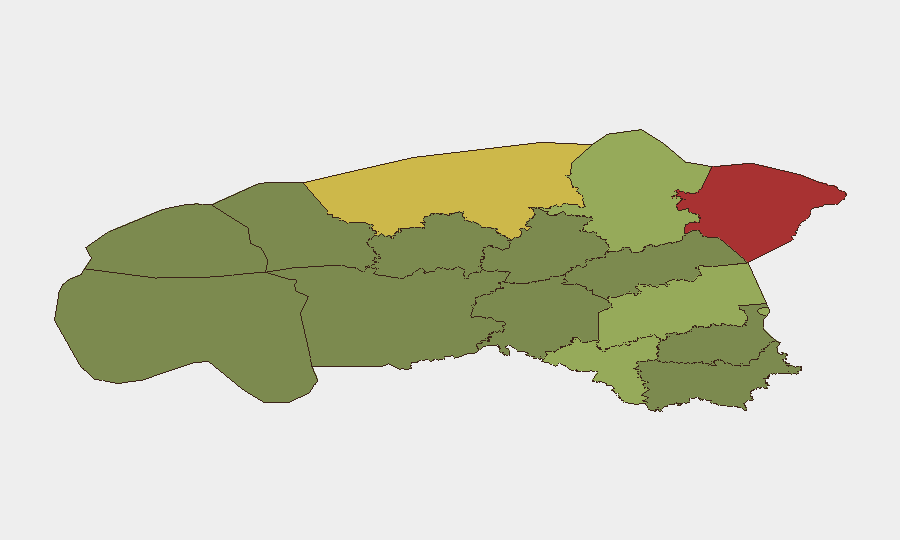
Estonia remains a low-threat environment globally (ranked #142, composite score 6) with stable democratic institutions and strong NATO/EU integration. However, sub-national risk concentration in northeastern border regions—particularly Ida-Viru County (score 78)—reflects proximity to Russian territory and ongoing geopolitical tensions. Current threat signals involve diplomatic friction with Lithuania and NATO military presence, rather than acute domestic security incidents. No confirmed security-impacting events have been corroborated in the past 24–48 hours.
Key Developments
- 2026-07-07 · Diplomatic Statements (Estonia–Lithuania). Two public statements logged between Estonia and Lithuania on 7 July; no specific location or operational detail available from current open-source confirmation. Status and impact require institutional follow-up.
- 2026-07-07 · NATO Military Activity (Estonia). Two "military/police power show" signals associated with NATO and Estonia on 7 July. Likely routine exercise or deployment visibility; no incident or disruption reported. Context and scale require verification.
- 2026-07-07 · Regional Diplomatic Signal (Latvia–Lithuania). Public statement logged between Latvia and Lithuania; indirect relevance to Estonia threat posture. Suggests Baltic trilateral tension; operational impact unclear.
- No corroborated domestic security incidents (civil unrest, crime events, infrastructure disruption, or travel-risk alerts) validated across multiple independent sources in the 24–48-hour window.
Highest-Risk Areas
Ida-Viru County (risk 78) and Harju County (risk 68)—both containing or bordering the Russian frontier—drive the majority of tracked threat signals. Ida-Viru's elevated score reflects its geography along the Russian border and historical sensitivity to cross-border cyber activity, energy infrastructure interdependency, and occasional geopolitical posturing. Harju County, encompassing Tallinn and the nation's capital infrastructure, carries elevated exposure to state-level cyber targeting and supply-chain disruption affecting government and financial systems. Tartu County (58) and Valga County (55) represent secondary-risk zones with lower but persistent border-proximity vulnerabilities. Southern and western counties (Võru, Viljandi, Põlva) show materially lower composite scores, indicating reduced geopolitical and organized-crime footprint.
How GeoBit Would Assist
Security teams operating in Estonia would benefit from AOI Monitoring & Early Warning (persistent watch on Ida-Viru and Harju Counties with alerts on cross-border activity, infrastructure incidents, or diplomatic escalation); Intel Sweep and multi-language OSINT (continuous monitoring of Estonian police, government, and regional media for unconfirmed threats); and Network & Actor Analysis (tracking state and non-state cyber actors targeting Estonia's digital infrastructure and NATO-adjacent assets). Routing & Network Analysis can model alternative travel and supply-chain corridors if border or infrastructure incidents occur.
7-Day Outlook
Near-term trajectory remains stable, with no acute security deterioration signaled. Current diplomatic and NATO visibility is consistent with baseline Baltic geopolitical friction and routine military posture-maintenance; no imminent operational escalation is evident. Continued monitoring of Estonia–Lithuania relations and Russian border-region activity is warranted to detect early warning of instability.
Highest-Risk Areas — Ranked
| # | State / Region | Risk |
|---|---|---|
| 1 | Ida-Viru County | 78 |
| 2 | Harju County | 68 |
| 3 | Tartu County | 58 |
| 4 | Valga County | 55 |
| 5 | Lääne-Viru County | 52 |
| 6 | Pärnu County | 35 |
| 7 | Rapla County | 32 |
| 8 | Jõgeva County | 30 |
| 9 | Järva County | 28 |
| 10 | Viljandi County | 25 |
| 11 | Põlva County | 22 |
| 12 | Võru County | 18 |
Sources
Previous Daily Briefs
A new Estonia brief is written every day — each with its own risk map and downloadable CSV. Here's the last week; use the calendar to go further back.
📅 Browse every day by calendar →
Highlighted days have a brief. Tap a day for that day's map & analysis, or “csv” for that day's dataset ($5).
Atlas — our AI intelligence desk — emails them this snapshot personally. Nothing else, no list.