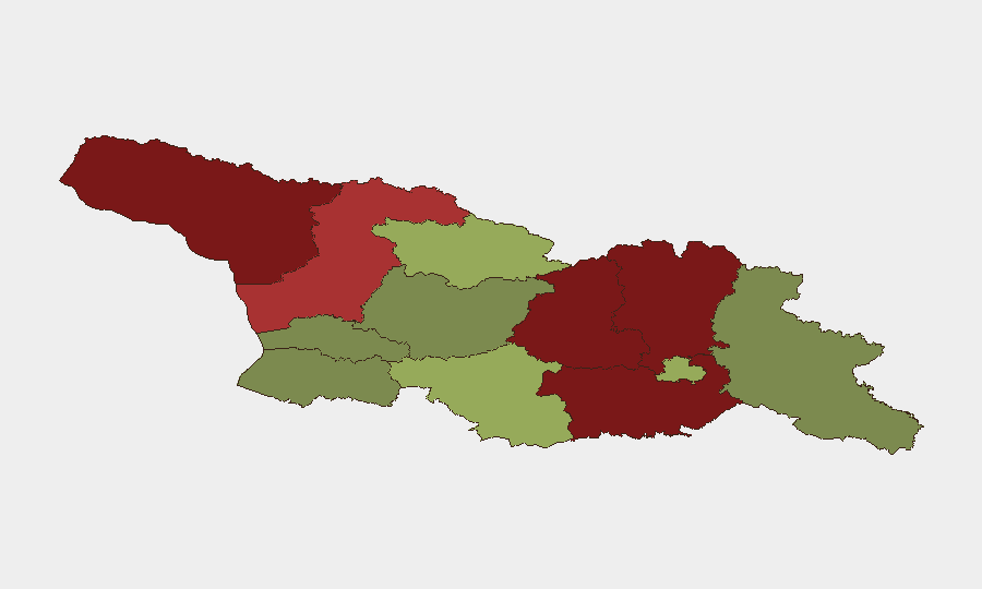
Situation Summary
Georgia remains a composite threat level #57 globally (score 21/100) with a stable but tense security posture. The country faces persistent territorial instability in breakaway regions (Abkhazia and South Ossetia) and recent signals of domestic political friction, though no major security incidents have been confirmed in open reporting over the last 24–48 hours. Infrastructure vulnerabilities, including recent flooding in multiple regions, compound duty-of-care risks for personnel and assets. The environment warrants active monitoring but does not indicate an acute, imminent threat to most commercial or diplomatic operations.
Key Developments
- Georgia (nationwide) – 7 July 2026
Political tension signals recorded across the country: ministerial statements, legal activity, police arrests, and voter disapproval noted in open monitoring, though specific locations, times, and charges remain unconfirmed in corroborating sources.
- Georgia (multiple regions) – early July 2026
Two flood events reported affecting road access, power, and water supply in unspecified regions; exact locations, dates, and casualty/damage figures not yet detailed in available open-source reporting.
- Abkhazia & South Ossetia (de facto territories) – 7 July 2026
Ongoing territorial instability signals persist; no new major military or civilian incidents confirmed, but baseline unrest remains consistent with historical patterns in these breakaway regions.
*Note: No additional discrete, time-stamped security incidents meeting 24–48 hour confirmation criteria are available in current open-source reporting.*
Highest-Risk Areas
Abkhazia (risk 95) and the South Caucasus disputed territories remain the primary drivers of Georgia's overall threat profile, followed by the contiguous regions of Shida Kartli (88), Lower Kartli (85), and Mtskheta-Mtianeti (82) along the occupied boundaries. These zones carry persistent risks of military confrontation, restricted freedom of movement, and limited state authority. Tbilisi (45) and the western regions (Samegrelo-Upper Svaneti, 78) present secondary but distinct risks—the capital faces political tension and protest potential, while the northwest corridor has experienced cross-border instability. Personnel and supply chains in or transiting these areas face elevated exposure to conflict escalation, territorial restrictions, and infrastructure disruption.
How GeoBit Would Assist
Security teams protecting people and assets in Georgia should leverage AOI (Area-of-Interest) Monitoring & Early Warning to establish persistent watch on Abkhazia, South Ossetia, and high-risk border regions, with configured alerting for military movement, road closures, or civil unrest. Intel Sweep and multi-language OSINT fusion (X/Twitter, Telegram, local media) provide near-real-time signal detection across political statements, protest activity, and arrest patterns—critical for assessing political risk in Tbilisi and regional capitals. GIS & Spatial Analysis combined with Routing & Network Analysis enable security teams to plan alternative routes and monitor infrastructure status (roads, power, water) affected by flooding or military activity, supporting duty-of-care compliance for personnel movement.
7-Day Outlook
The outlook remains stable but uncertain. Political tension signals and recent flooding are unlikely to escalate into major security crises in the next 7 days, but both warrant continued close monitoring. Abkhazia and South Ossetia carry non-zero risk of tactical military incidents or administrative restrictions that could disrupt access or movement; any such event would likely impact cross-border logistics and regional travel. Organizations should maintain flexible travel protocols and contingency planning for supply-chain disruption in contested and flood-affected areas.
Highest-Risk Areas — Ranked
| # | State / Region | Risk |
|---|---|---|
| 1 | Autonomous Republic of Abkhazia | 95 |
| 2 | Shida Kartli | 88 |
| 3 | Lower Kartli | 85 |
| 4 | Mtskheta-Mtianeti | 82 |
| 5 | Samegrelo-Upper Svaneti | 78 |
| 6 | Samtskhe-Javakheti | 48 |
| 7 | Tbilisi | 45 |
| 8 | Racha-Lechkhumi and Kvemo Svaneti | 42 |
| 9 | Kakheti | 38 |
| 10 | Autonomous Republic of Adjara | 35 |
| 11 | Imereti | 32 |
| 12 | Guria | 28 |
Sources
Previous Daily Briefs
A new Georgia brief is written every day — each with its own risk map and downloadable CSV. Here's the last week; use the calendar to go further back.
📅 Browse every day by calendar →
Highlighted days have a brief. Tap a day for that day's map & analysis, or “csv” for that day's dataset ($5).
Atlas — our AI intelligence desk — emails them this snapshot personally. Nothing else, no list.