Situation Summary
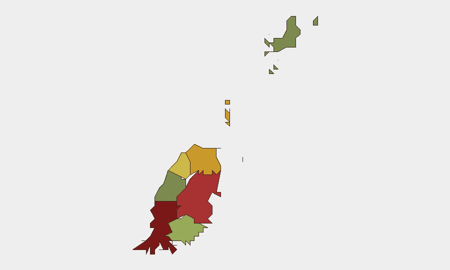
Grenada remains a low-threat environment at global rank #163 with a composite threat score of 5 and zero tracked events in the assessment period. The security landscape is concentrated in Saint George parish, which carries significantly elevated risk (92) relative to outer islands and southern parishes. No new security developments meeting the 24–48 hour criteria have been confirmed; the most recent incident—a fatal boating accident on 8 August during Spicemas—falls outside the current reporting window and does not reflect an ongoing threat pattern.
Key Developments
No confirmed security or travel-risk developments from the last 24–48 hours were identified in available sources. The most recent confirmed incident—a boating fatality on Grand Anse Beach, Saint George's, on 8 August 2026—occurred outside the current reporting window. Ongoing monitoring of local law enforcement, news, and social-media channels has not yielded additional events meeting GeoBit's verification standard for same-period reporting.
Highest-Risk Areas
Saint George parish dominates the risk profile, with a composite score of 92—substantially higher than all other parishes and nearly the entire national average. Saint Andrew (78) and Saint Patrick (71) follow, suggesting that risk is concentrated in the northwestern and central upland zones. Carriacou and Petite Martinique, the outer islands, remain lowest-risk at 12. The concentration of risk in Saint George—home to the capital, St. George's, and major tourist infrastructure including Grand Anse Beach—reflects typical urban hazard exposure: higher volumes of transient populations, maritime traffic, and venue-based incidents during seasonal events such as Carnival. Corporate teams with personnel or assets in Saint George should prioritize awareness of local incident reporting and venue-specific safety protocols.
How GeoBit Would Assist
Organizations operating in Grenada would benefit from AOI Monitoring & Early Warning configured on Saint George's commercial and hospitality zones to flag emerging incidents in real time. OSINT fusion combining local news, social media, and law-enforcement channels (via X/Twitter and Telegram OSINT) would provide early signal of safety concerns before they escalate. GIS & Spatial Analysis layered with maritime and aviation tracking would support duty-of-care assessments for personnel traveling to or working near high-risk parishes and major transport hubs.
7-Day Outlook
No imminent security deterioration is forecast. Spicemas (Carnival) typically concentrates risk in early August; the passage of this event window should see a return to baseline operational conditions. Continued monitoring of Saint George's urban environment and maritime zones remains prudent for corporate teams with ongoing presence or regular travel to the island.
Highest-Risk Areas — Ranked
| # | State / Region | Risk |
|---|---|---|
| 1 | Saint George | 92 |
| 2 | Saint Andrew | 78 |
| 3 | Saint Patrick | 71 |
| 4 | Saint Mark | 64 |
| 5 | Saint David | 52 |
| 6 | Saint John | 38 |
| 7 | Carriacou and Petite Martinique | 12 |
Sources
Previous Daily Briefs
A new Grenada brief is written every day — each with its own risk map and downloadable CSV. Here's the last week; use the calendar to go further back.
- August 12, 2026
- August 10, 2026
- August 8, 2026
- August 6, 2026
- August 5, 2026
- August 4, 2026
- August 3, 2026
📅 Browse every day by calendar →
Highlighted days have a brief. Tap a day for that day's map & analysis, or “csv” for that day's dataset ($5).
Atlas — our AI intelligence desk — emails them this snapshot personally. Nothing else, no list.