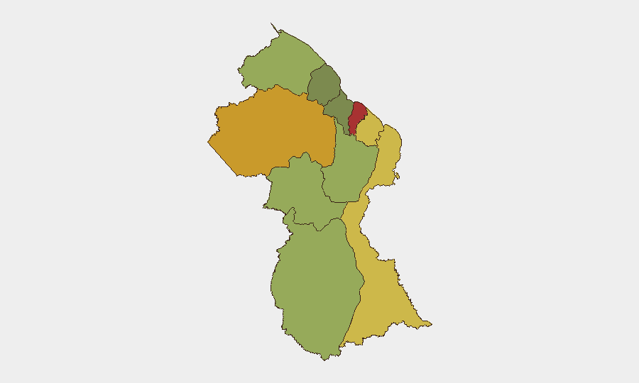
Situation Summary
Guyana remains a moderate-risk jurisdiction (global rank #70) with significant geographic variance in threat intensity. No major security incidents, civil unrest, or infrastructure disruptions have been reported in the last 24–48 hours; current activity reflects routine political discourse and economic governance discussions. The security environment is stable but fragmented by region, with coastal urban centers and interior mining zones presenting elevated risk profiles that warrant differentiated monitoring and contingency planning.
Key Developments
- 07-05 · National level – Governance activity. Guyana Chronicle reporting on the Guyana Development Bank Bill 2026, focused on business registration and development financing. No security implications identified.
- 07-05 · National level – Social commentary. Opinion-piece discussion of social resilience and interpersonal conflict preparedness; no specific incidents, protests, or violent events corroborated.
- 07-04–05 · Diplomatic tension (regional). Guyana has issued disapproval statements toward Panama (two separate signals, 07-04); Colombian government demands toward Guyana also registered (07-05). No border incursions or operational security events reported as of writing.
- 07-03 · Public statement activity. Guyanese social and news activity; no security or protest event corroborated.
- No confirmed reports of crime spikes, protests, or conflict incidents in the last 24–48 hours in specific sub-national locations.
Highest-Risk Areas
Demerara-Mahaica (risk 78) and Cuyuni-Mazaruni (risk 72) are the primary drivers of national threat concentration, likely reflecting Georgetown's urban crime, trafficking, and gang activity, combined with interior mining-zone labor disputes and illicit mining operations. Mahaica-Berbice (65) and East Berbice-Corentyne (62) present secondary concern zones. The coastal regions (Demerara-Mahaica, Mahaica-Berbice, East Berbice-Corentyne) account for most population density, economic activity, and reported incidents; interior zones (Cuyuni-Mazaruni, Upper Demerara-Berbice) face resource-competition and trafficking risk. Organizations with personnel or assets in Georgetown or mining/port areas should apply heightened duty-of-care protocols.
How GeoBit Would Assist
Intel Sweep & OSINT fusion would provide continuous monitoring of Guyana Chronicle, Stabroek News, Demerara Waves, and GPF/GDF official channels to detect emerging crime, protest, or conflict signals in real time. AOI Monitoring & Early Warning applied to Demerara-Mahaica, ports, and major infrastructure nodes would enable persistent geographic surveillance with automated alerting for incidents affecting corporate operations. Network & Actor Analysis would map trafficking, gang, and labor-dispute networks in mining zones to support risk assessment and route planning. Routing & Network Analysis would support alternative-route and safe-passage planning for personnel in high-risk sub-national areas.
7-Day Outlook
No acute security deterioration is projected over the next seven days based on current reporting and event trajectories. Low-level political and social activity will likely persist; organizations should maintain standard security postures and continue monitoring local media and official government/defense channels. Coastal urban security (Georgetown, Linden, New Amsterdam) and interior mining-zone logistics should remain under enhanced scrutiny as baseline practice.
Highest-Risk Areas — Ranked
| # | State / Region | Risk |
|---|---|---|
| 1 | Demerara-Mahaica | 78 |
| 2 | Cuyuni-Mazaruni | 72 |
| 3 | Mahaica-Berbice | 65 |
| 4 | East Berbice-Corentyne | 62 |
| 5 | Upper Demerara-Berbice | 58 |
| 6 | Potaro-Siparuni | 48 |
| 7 | Barima-Waini | 45 |
| 8 | Upper Takutu-Upper Essequibo | 42 |
| 9 | Pomeroon-Supenaam | 38 |
| 10 | Essequibo Islands | 35 |
Previous Daily Briefs
A new Guyana brief is written every day — each with its own risk map and downloadable CSV. Here's the last week; use the calendar to go further back.
📅 Browse every day by calendar →
Highlighted days have a brief. Tap a day for that day's map & analysis, or “csv” for that day's dataset ($5).
Atlas — our AI intelligence desk — emails them this snapshot personally. Nothing else, no list.