Situation Summary
Ivory Coast remains stable with no corroborated security incidents reported in the last 24–48 hours across open-source news, local media, and regional risk feeds. The national composite threat score of 17 reflects a low acute-incident environment relative to global benchmarks. Underlying structural risks—including cross-border activity in northern districts, land disputes, and informal security sector dynamics—persist but show no signs of acute escalation at present.
Key Developments
No discrete security, civil-unrest, crime, infrastructure-disruption, or travel-risk incidents were reported or corroborated for Ivory Coast between 3–5 August 2026 across available open sources, regional advisories, or major news outlets.
Highest-Risk Areas
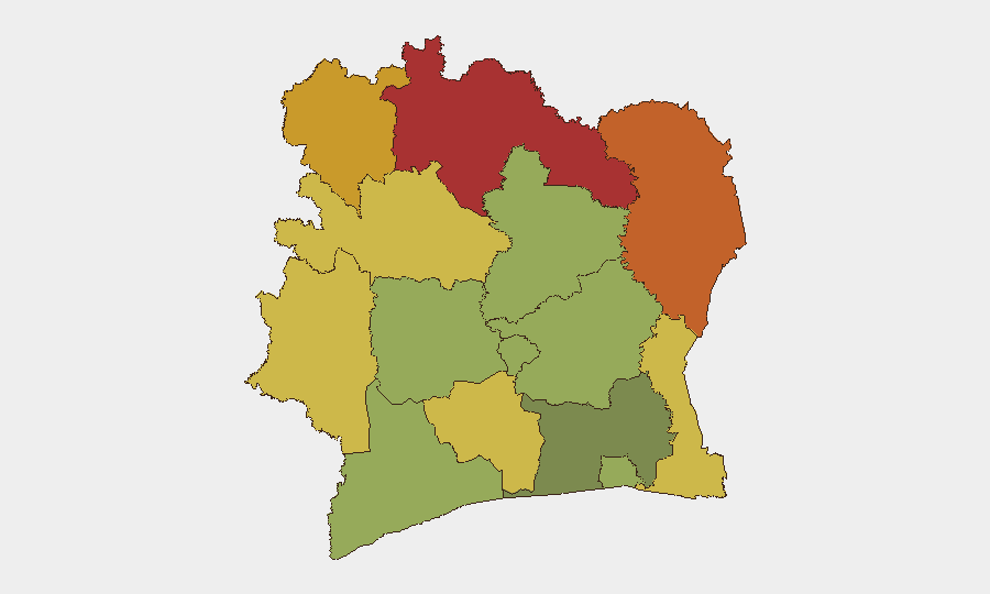
Northern and northeastern districts drive the country's sub-national risk profile. Savanes (78), Zanzan (75), Denguélé (72), and Comoé (70) districts all exceed baseline risk thresholds, primarily due to proximity to porous borders with Mali, Burkina Faso, and Guinea; limited state presence; and recurring reports of informal militia activity and cross-border trafficking. Montagnes, Woroba, and Gôh-Djiboua districts (68, 65, and 60 respectively) register elevated risk linked to land-tenure conflict and resource-competition dynamics. Central and southern zones, including Abidjan (45), remain substantially lower-risk, though petty crime and informal-sector disputes warrant standard corporate duty-of-care protocols.
How GeoBit Would Assist
Organizations with personnel or assets in Ivory Coast should deploy Area-of-Interest (AOI) Monitoring & Early Warning on high-risk northern districts to detect emerging incidents—road closures, demonstrations, armed movement—in real time. OSINT Fusion & Corroboration (combining X/Twitter, local media, government statements, and regional security feeds) confirms whether unverified rumors constitute genuine threats or local noise. Routing & Network Analysis ensures rapid identification of alternative transport corridors should primary routes become unsafe; combined with Conflict & Military mapping, this supports duty-of-care travel briefings and contingency planning for field teams.
7-Day Outlook
No acute trigger for escalation is apparent; however, normal seasonal and political rhythms (including any administrative or electoral activity in August 2026) should be monitored. The northern border environment remains a persistent watch area, particularly for informal cross-border movement and resource disputes that could spike quickly with limited warning.
Next Brief Refresh: 2026-08-06 06:00 UTC (or upon corroborated incident report).
Data Cutoff: 2026-08-05 23:59 UTC.
Highest-Risk Areas — Ranked
| # | State / Region | Risk |
|---|---|---|
| 1 | Savanes District | 78 |
| 2 | Zanzan District | 75 |
| 3 | Denguélé District | 72 |
| 4 | Comoé District | 70 |
| 5 | Montagnes District | 68 |
| 6 | Woroba District | 65 |
| 7 | Gôh-Djiboua District | 60 |
| 8 | Sassandra-Marahoué District | 58 |
| 9 | Vallée du Bandama District | 55 |
| 10 | Bas-Sassandra District | 52 |
| 11 | Lacs District | 48 |
| 12 | Abidjan | 45 |
Sources
Previous Daily Briefs
A new Ivory Coast brief is written every day — each with its own risk map and downloadable CSV. Here's the last week; use the calendar to go further back.
📅 Browse every day by calendar →
Highlighted days have a brief. Tap a day for that day's map & analysis, or “csv” for that day's dataset ($5).
Atlas — our AI intelligence desk — emails them this snapshot personally. Nothing else, no list.