Situation Summary
Latvia experienced multiple unmanned aerial vehicle (UAV) incursions from Russian airspace during the night of 4–5 July 2026, with at least two drones confirmed crashed on Latvian territory. One drone struck an empty oil storage tank in the Rēzekne district; a second fire alert at the same facility was later deemed precautionary. Airspace threat warnings remained active across three eastern districts as of 05:00 local time, indicating an unresolved security situation in Latvia's border regions.
Key Developments
- Rēzekne district, East-West Transit branch (04 July, night / 05 July, early morning): Two drones crossed into Latvian airspace from Russia; one struck an unoccupied oil storage tank. Latvian military confirmed multiple UAV incursions over the course of the incident.
- Rēzekne city (05 July, ~03:30 local time): Emergency services responded to reports of a fire at the oil storage facility; firefighters found no open flame but cooled one tank as a precautionary measure.
- Eastern Latvia / Latgale region (04–05 July, overnight): Local residents reported engine sounds, explosions, and visible flashes consistent with active airspace threats. A television crew documented another drone overhead during response operations.
- Three eastern districts (05 July, ongoing): Airspace threat warnings remained in effect across multiple administrative areas, indicating the incursion event was not fully contained by morning.
- Rēzekne Regional Council confirmation (05 July): Chair Guntars Skudra verified that one drone had impacted the East-West Transit branch territory, establishing the incident as a deliberate or navigational incursion into critical infrastructure.
Highest-Risk Areas
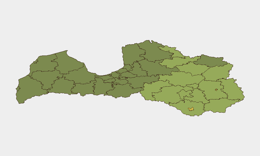
Eastern border municipalities—particularly Rēzekne (risk 68) and Daugavpils (risk 65)—dominate Latvia's threat profile and are consistent with the current UAV activity. The clustering of nine of the twelve highest-risk sub-national areas in Latgale and the southeastern Daugava river region reflects chronic exposure to cross-border airspace violations, proximity to Russian territory, and the presence of energy and transit infrastructure. Risk scores increase markedly in districts with major fuel storage, logistics hubs, or direct border contact. Organizations with assets in Rēzekne, Rēzeknes novads, or Daugavpils should treat airspace warnings as routine threat vectors.
How GeoBit Would Assist
Security teams protecting personnel or assets in Latvia would deploy AOI Monitoring & Early Warning capabilities on the three active threat districts to receive real-time alerting on airspace incursions or military activity. Conflict & Military force tracking and Satellite & Imagery analysis would provide persistent visibility of Russian cross-border positioning and damage assessment at affected infrastructure sites. Intel Sweep and multi-language OSINT fusion (X/Twitter, Telegram, local media) would enable 24-hour corroboration of official warnings and rapid detection of secondary incidents before mainstream reporting.
7-Day Outlook
Continued low-level UAV incursions or airspace violations are probable in border districts through at least early next week, driven by ongoing Russian military operations and demonstrated tolerance for cross-border drone activity. Energy and logistics facilities in the Rēzekne and Daugavpils areas should maintain elevated alert posture and review emergency response protocols. No tactical escalation is currently evident, but cumulative incidents increase the likelihood of broader airspace restrictions or emergency service strain in the eastern region.
Highest-Risk Areas — Ranked
| # | State / Region | Risk |
|---|---|---|
| 1 | Rēzekne | 68 |
| 2 | Daugavpils | 65 |
| 3 | Rēzeknes novads | 58 |
| 4 | Ludzas novads | 55 |
| 5 | Balvu novads | 52 |
| 6 | Preiļu novads | 50 |
| 7 | Krāslavas novads | 48 |
| 8 | Jēkabpils novads | 47 |
| 9 | Augšdaugavas novads | 46 |
| 10 | Aizkraukles novads | 45 |
| 11 | Varakļānu novads | 44 |
| 12 | Līvānu novads | 43 |
Sources
Previous Daily Briefs
A new Latvia brief is written every day — each with its own risk map and downloadable CSV. Here's the last week; use the calendar to go further back.
📅 Browse every day by calendar →
Highlighted days have a brief. Tap a day for that day's map & analysis, or “csv” for that day's dataset ($5).
Atlas — our AI intelligence desk — emails them this snapshot personally. Nothing else, no list.