Situation Summary
Lebanon remains in active conflict with Israel despite a US-mediated ceasefire framework announced in early July 2026. Cross-border hostilities—airstrikes, artillery fire, drone strikes, and ground clashes—continue at high intensity across southern Lebanon and the Beqaa Valley, with a cumulative death toll exceeding 4,300 since March. The ceasefire has proven permeable, with both Israeli forces and Hezbollah units reporting violations and engaging in active combat near the security zone, creating a high-casualty, unstable operational environment for civilians and international peacekeepers.
Key Developments
- Nabatieh al-Fawqa, Nabatieh Governorate (6 July): An Israeli drone strike killed four people—a school principal, her mother, a domestic worker, and a Syrian laborer—near a civilian family home. The IDF characterized the vehicle as a ceasefire violation; Lebanese authorities classified it as a civilian casualty incident.
- Southern Lebanon Security Zone (6 July): The IDF reported eliminating an armed operative detected inside the South Lebanon Security Zone near Israeli positions, labeling the presence a ceasefire violation.
- Countrywide airstrikes (6 July, past 24 hours): Israeli forces struck approximately 80 targets across Lebanon in a single 24-hour period; Lebanese Health Ministry reported 28 killed and 139 wounded on 6 July alone, with ongoing bombardment in border villages.
- Multiple southern locations (early 6 July): Israeli troops fired on two locations in southern Lebanon within hours of the ceasefire's formal start, according to on-the-ground reporting, despite the announced agreement.
- UNIFIL operations (6 July): UN peacekeepers reported active ground combat between Israeli forces and Hezbollah units in southern Lebanon, with restricted freedom of movement and heightened risk from unexploded ordnance near IDF deployment areas.
- Cross-border artillery and airstrikes (past 48 hours): Regional media documented over 40 Hezbollah-linked targets struck by Israeli forces, alongside artillery engagements, indicating sustained dual-mode offensive operations despite ceasefire claims.
Highest-Risk Areas
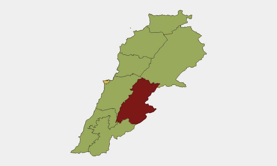
Beqaa Governorate (risk 85) and Beirut Governorate (69.9) drive the national ranking; Beqaa hosts militant infrastructure and Iranian-backed activities flagged in recent intelligence signals, while Beirut faces urban security fragmentation. The remaining seven governorates cluster at risk 55, reflecting the distributed nature of Hezbollah presence and Israeli targeting across the southern tier (South, Nabatieh, Baalbek-Hermel) and northern regions (Akkar, North). Southern Lebanon—particularly areas within 10–15 km of the Israeli border and near IDF security-zone perimeters—currently experiences the highest tempo of airstrikes, drone operations, and ground engagement, making it the primary casualty and displacement driver.
How GeoBit Would Assist
AOI Monitoring & Early Warning with persistent satellite and OSINT feeds on southern Lebanon and Beqaa would alert teams to strike patterns, troop movements, and IED/UXO concentrations before they affect personnel. Conflict & Military capabilities (battle mapping, force-structure tracking, weapons capability) combined with Network & Actor Analysis enable real-time tracking of Hezbollah and Israeli operational posture to support duty-of-care decisions on movement and shelter-in-place protocols. Routing & Network Analysis supports alternative journey planning for corporate staff and assets, bypassing high-casualty zones and active engagement corridors identified through GIS & Spatial Analysis of recent strike locations and UNIFIL-reported combat zones.
7-Day Outlook
Ceasefire violations are likely to persist through 7–14 July, with Israeli operations maintaining high strike frequency in the Beqaa and southern Lebanon. Casualty levels among civilians and displaced populations will remain elevated. Corporate teams should assume continued airstrikes, artillery fire, and restricted movement in southern governorates and prepare contingency evacuations or relocation of non-essential personnel.
Highest-Risk Areas — Ranked
| # | State / Region | Risk |
|---|---|---|
| 1 | Beqaa Governorate | 85 |
| 2 | Beirut Governorate | 69.9 |
| 3 | North Governorate | 55 |
| 4 | Akkar Governorate | 55 |
| 5 | Keserwan-Jbeil Governorate | 55 |
| 6 | Mount Lebanon Governorate | 55 |
| 7 | South Governorate | 55 |
| 8 | Nabatieh Governorate | 55 |
| 9 | Baalbek-Hermel Governorate | 55 |
Sources
Previous Daily Briefs
A new Lebanon brief is written every day — each with its own risk map and downloadable CSV. Here's the last week; use the calendar to go further back.
📅 Browse every day by calendar →
Highlighted days have a brief. Tap a day for that day's map & analysis, or “csv” for that day's dataset ($5).
Atlas — our AI intelligence desk — emails them this snapshot personally. Nothing else, no list.