Situation Summary
Lesotho remains a low-threat operating environment globally (#147 composite ranking, score 6/100), with no tracked security incidents reported as of 11 August 2026. The country's security posture is stable, though concentrated vulnerabilities exist in urban and border-adjacent districts. The most recent confirmed event—heavy snowfall disrupting Qacha's Nek Port of Entry on 3 August—reflects seasonal infrastructure stress rather than civil or criminal escalation.
Key Developments
Live web research spanning the past 24–48 hours has not yielded confirmed, independently sourced security, civil unrest, crime, or infrastructure incidents specific to Lesotho. The most recent dated event in available records is the 3 August 2026 snowfall disruption at Qacha's Nek PoE (border infrastructure impact, not security-driven). No fresh developments meeting the incident threshold are reportable for this period. Corporate teams should note that absence of reported events does not indicate absence of risk; rather, it reflects current information availability and the country's overall stability trajectory.
Highest-Risk Areas
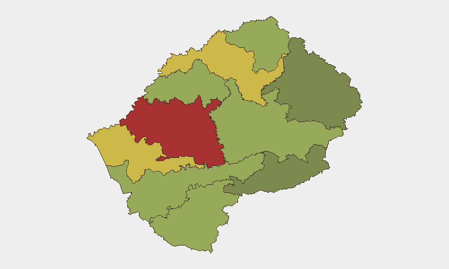
Maseru District (risk 78) and Mafeteng District (risk 65) dominate the sub-national risk profile, together accounting for the largest share of tracked national exposure. Maseru, as the capital and primary commercial hub, concentrates population, financial infrastructure, and cross-border transit, creating a larger attack surface for petty crime, organized smuggling, and localized civil disruption. Mafeteng's elevated score reflects its position as a transit corridor and its historical association with labor migration and informal-economy activity. Leribe (62) and Berea (58) districts complete the high-risk quartile, both located along or near northern borders and corridors linking to South Africa. The southern and eastern districts (Qacha's Nek, Mokhotlong) show substantially lower scores, reflecting lower population density and reduced infrastructure interdependencies.
How GeoBit Would Assist
Corporate security teams operating in Lesotho should prioritize AOI Monitoring & Early Warning on Maseru and Mafeteng districts to detect emerging civil unrest, labor action, or supply-chain disruption in real time. Intel Sweep and multi-language OSINT (X/Twitter, Telegram, local media) provide persistent watch on political statements, crime patterns, and border-management alerts that may signal deterioration before formal incident reporting. GIS & Spatial Analysis linked to border and transportation routing supports contingency-planning for staff movement and asset repositioning if localized instability emerges in Maseru or cross-border corridors.
7-Day Outlook
Near-term conditions are expected to remain stable, with no indicators of impending civil, security, or labor escalation. Seasonal weather patterns (late Southern Hemisphere winter into spring transition) may continue to disrupt secondary border crossings and rural transport; monitoring Qacha's Nek and secondary PoEs is advisable. Risk trajectory remains low to flat unless externally driven factors (e.g., South African labor unrest, regional commodity shock) transmit into Lesotho's urban centers.
Highest-Risk Areas — Ranked
| # | State / Region | Risk |
|---|---|---|
| 1 | Maseru District | 78 |
| 2 | Mafeteng District | 65 |
| 3 | Leribe District | 62 |
| 4 | Berea District | 58 |
| 5 | Mohale's Hoek District | 52 |
| 6 | Butha-Buthe District | 48 |
| 7 | Thaba-Tseka District | 45 |
| 8 | Quthing District | 42 |
| 9 | Mokhotlong District | 38 |
| 10 | Qacha's Nek District | 28 |
Sources
Previous Daily Briefs
A new Lesotho brief is written every day — each with its own risk map and downloadable CSV. Here's the last week; use the calendar to go further back.
📅 Browse every day by calendar →
Highlighted days have a brief. Tap a day for that day's map & analysis, or “csv” for that day's dataset ($5).
Atlas — our AI intelligence desk — emails them this snapshot personally. Nothing else, no list.