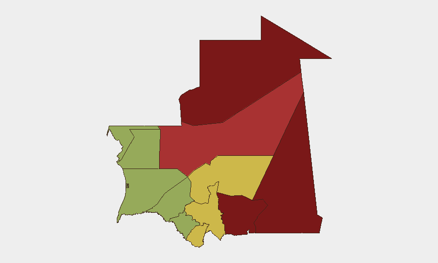
Situation Summary
Mauritania's security environment remains fragmented by persistent regional disparities rather than nationwide instability. The last 24–48 hours show isolated incidents—a traffic accident involving a senior official, a reported vehicular assault on an opposition figure, and a fresh judicial ruling against MPs—but no coordinated escalation or mass civil unrest. The northern and eastern border regions (Tiris Zemmour, Hodh Ech Chargui, Adrar) continue to pose acute risks from terrorism, armed groups, and kidnapping, while the coastal and southern areas remain significantly more stable for movement and operations.
Key Developments
- Nouakchott–Atar road, Adrar region (c. 4–5 August): Tiris Zemmour regional governor Idrissa Demba Córéra sustained minor injuries in a traffic accident on the main intercity highway and was evacuated to Atar hospital. No foul play reported; incident reflects general road-safety hazards on major routes.
- Nouakchott Court of Appeal (c. 4–5 August): Court issued a ruling barring opposition MPs Mariem Cheikh and Gamu Achour from political and civil rights for five years, reducing their prison sentences from four to two years. Decision may inflame opposition sentiment but has not yet triggered documented unrest.
- Nouadhibou, Dakhlet Nouadhibou region (c. 4–5 August): Opposition MP and IRA leader Biram Dah Abeid reported a vehicular assault attempt in the city; his organization alleges police-linked perpetrators. No security-force confirmation or follow-on violence documented at time of reporting.
- Nationwide cyber threat disclosure (early August, covering H1 2026): PAFIID program reported detection of over 10,000 cyber threats and neutralization of 470 confirmed incidents during January–June 2026, indicating ongoing malware, phishing, and network-exploitation activity against corporate and government infrastructure.
- Tawilla area, north of Nouakchott–Akjoujt axis (29–30 July, ongoing relevance): Mauritanian General Staff conducted live-fire drills with artillery and medium machine guns; civilian avoidance of the zone was advised. Exercise period has ended but unexploded ordnance and militarized-area risks persist in the region.
- German Foreign Office advisory (reiterated 2026): Official travel warnings remain in force for remote Sahara and Sahel zones and Mali/Algeria borders, citing terrorism, kidnapping, criminal armed bands, and potential armed clashes.
Highest-Risk Areas
Tiris Zemmour (risk 95) and Hodh Ech Chargui (risk 85) dominate the threat landscape, reflecting their proximity to Mali and the prevalence of terrorist and armed-criminal activity in those border zones. Hodh El Gharbi, Adrar, and Tagant follow closely, each presenting terrorism, kidnapping, and resource-scarcity-driven instability. In contrast, coastal regions (Dakhlet Nouadhibou, Brakna, Trarza) and central areas score substantially lower, permitting routine commercial and diplomatic operations with standard precautions. Risk is overwhelmingly concentrated in the north and east.
How GeoBit Would Assist
Teams should leverage AOI Monitoring & Early Warning on high-risk regions to track militant movements and cross-border incidents; Intel Sweep and multi-language OSINT to detect politically motivated threats (such as the reported assault on Biram Dah Abeid) and judicial developments before they escalate; and Routing & Network Analysis to identify safer intercity and border-crossing corridors, especially given the recent traffic incident on the Nouakchott–Atar axis. Cyber threat and SIGINT capabilities can help corporate networks anticipate phishing and malware campaigns targeting Mauritanian infrastructure.
7-Day Outlook
No imminent nationwide escalation is expected; however, the judicial ruling against opposition MPs and the alleged assault on a high-profile opposition figure warrant close monitoring for protest activity or political retaliation. Travelers and assets in the northern and eastern regions should maintain heightened vigilance against terrorism and armed-group activity. The security baseline is likely to remain regionally stratified, with southern and coastal zones stable and border areas persistently dangerous.
Highest-Risk Areas — Ranked
| # | State / Region | Risk |
|---|---|---|
| 1 | Tiris Zemmour | 95 |
| 2 | Hodh Ech Chargui | 85 |
| 3 | Hodh El Gharbi | 80 |
| 4 | Adrar | 78 |
| 5 | Tagant | 68 |
| 6 | Guidimaka | 65 |
| 7 | Assaba | 62 |
| 8 | Gorgol | 58 |
| 9 | Trarza | 55 |
| 10 | Inchiri | 52 |
| 11 | Brakna | 48 |
| 12 | Dakhlet Nouadhibou | 45 |
Sources
Previous Daily Briefs
A new Mauritania brief is written every day — each with its own risk map and downloadable CSV. Here's the last week; use the calendar to go further back.
📅 Browse every day by calendar →
Highlighted days have a brief. Tap a day for that day's map & analysis, or “csv” for that day's dataset ($5).
Atlas — our AI intelligence desk — emails them this snapshot personally. Nothing else, no list.