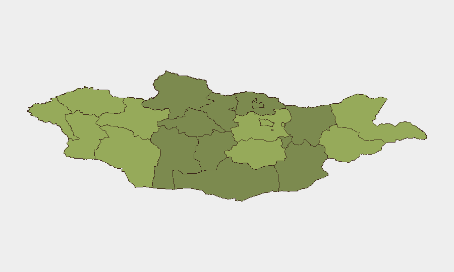
Situation Summary
Mongolia presents a composite threat level of 4 (globally unranked) with no tracked security events in the current reporting window. Open-source monitoring for 29–30 July 2026 yields no verifiable discrete incidents in conflict, civil unrest, organized crime, political instability, or acute infrastructure failure. The security landscape remains characterized by baseline structural risks (border regions, economic volatility, seasonal health concerns) rather than active destabilization.
Key Developments
No verifiable security incidents reported in Mongolia for 29–30 July 2026. Available incident feeds (Mongolia Daily, regional police/health accounts, and travel-risk advisories) lack timestamped events meeting the 24–48 hour recency threshold. Earlier reported items—including a plague case (20 July), measles surveillance data (24 July), and road closures (24–27 July)—fall outside the current window and are therefore presented as background context only. Ongoing public-health monitoring (measles cluster, earlier plague documentation) continues, but no new acute incidents are confirmed for the last two days.
Highest-Risk Areas
Dornod and Sükhbaatar (eastern border regions) lead sub-national rankings at risk scores 58 and 55, driven by proximity to the Russian border, limited infrastructure resilience, and historical trafficking and contraband routes. Uvs and Khovd (northwestern and western border zones, scores 52–50) face similar border-management pressures and remote-area enforcement challenges. Ulaanbaatar (score 45), while lower-ranked than border aimags, concentrates population, economic activity, and administrative function, making it a secondary priority for layered monitoring. Eastern and western border regions remain the primary focus for duty-of-care teams; capital-based operations face standard urban crime and infrastructure reliability risks rather than transnational threat vectors.
How GeoBit Would Assist
AOI Monitoring & Early Warning on Dornod and Sükhbaatar would provide persistent watch for border-crossing anomalies, informal trafficking activity, and cross-border security incidents before they escalate to corporate impact. Intel Sweep and multi-language OSINT (targeting Mongolian and Russian-language sources, local police feeds, and regional media) would capture incidents and policy shifts not visible in English-language channels, critical for early detection in remote zones. Risk & Threat Assessment and GIS & Spatial Analysis enable teams to map asset locations against the highest-risk aimags and model alternative routing, supply-chain resilience, and contingency planning for personnel or logistics operating in or transiting through border regions.
7-Day Outlook
No acute escalation is forecast for the coming week; Mongolia's threat trajectory remains stable barring external shocks (border tensions, major health outbreaks, or economic disruption). Seasonal factors (summer travel, increased cross-border activity, livestock movement) maintain baseline exposure in remote and border areas. Continued monitoring of health advisories and regional border activity is warranted for teams with assets in Dornod, Sükhbaatar, or western aimags.
Highest-Risk Areas — Ranked
| # | State / Region | Risk |
|---|---|---|
| 1 | Dornod | 58 |
| 2 | Sükhbaatar | 55 |
| 3 | Uvs | 52 |
| 4 | Khovd | 50 |
| 5 | Bayan-Ölgii | 48 |
| 6 | Govi-Altai | 46 |
| 7 | Ulaanbaatar | 45 |
| 8 | Zavkhan | 44 |
| 9 | Töv | 42 |
| 10 | Dundgovi | 40 |
| 11 | Darkhan-Uul | 38 |
| 12 | Ömnögovi | 37 |
Sources
Previous Daily Briefs
A new Mongolia brief is written every day — each with its own risk map and downloadable CSV. Here's the last week; use the calendar to go further back.
📅 Browse every day by calendar →
Highlighted days have a brief. Tap a day for that day's map & analysis, or “csv” for that day's dataset ($5).
Atlas — our AI intelligence desk — emails them this snapshot personally. Nothing else, no list.