Situation Summary
Papua New Guinea remains a high-fragmentation security environment with composite threat indicators elevated but stable; no major state-level incidents have been reported in the last 24–48 hours. The highlands provinces (Southern Highlands, Enga, Hela, Eastern Highlands, and Western Highlands) continue to drive national risk due to persistent tribal violence, clan-based armed groups, and limited state policing capacity. A fatal marine incident involving Chinese nationals near Lihir Island in New Ireland Province has emerged as the only significant documented event within the reporting window, underscoring ongoing hazards to foreign nationals in remote and maritime zones.
Key Developments
- Lihir Island, New Ireland Province – boat sinking with fatalities. A vessel named *Zhephir* sank off Lihir Island on 3–4 August while returning from a picnic trip to Mali Island, carrying seven Chinese nationals; all seven are believed to have perished. The incident indicates a mass-fatality marine accident with likely search and recovery operations underway and significant consular implications for Chinese mission and PNG authorities. *(Last 24–48 hours; multi-sourced)*
- No major tribal violence, civil unrest, or infrastructure disruptions reported in the last 24–48 hours. Most recent provincial police reports and open-source security feeds reflect incidents from mid-July or earlier (e.g., Unitech dormitory incident on 18 July, temporary Goroka airport closure on 28 July). Absence of new large-scale reported clashes in the highlands does not indicate reduced underlying risk; surveillance gaps and reporting delays are common.
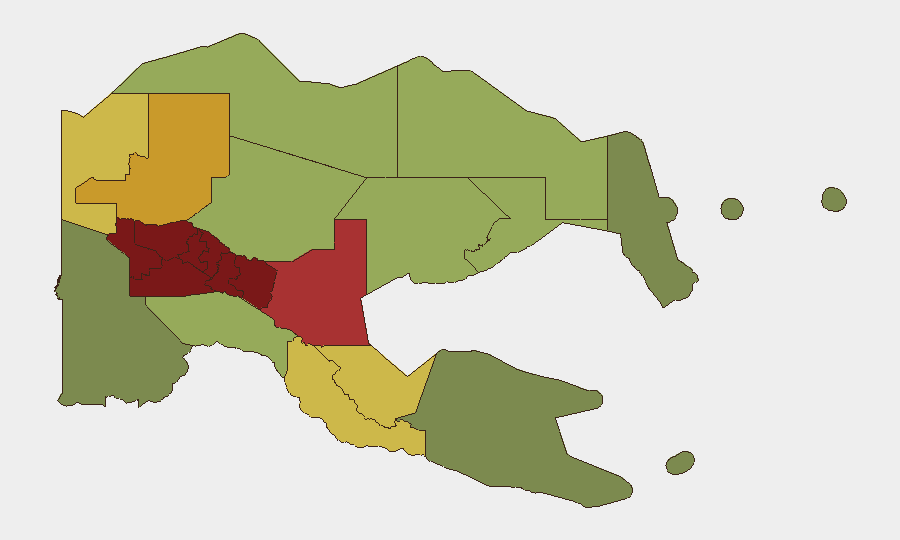
- Baseline provincial security posture unchanged. Southern Highlands, Enga, and Hela provinces remain assessed at the highest individual risk levels (98, 96, 94 respectively); no current indicators suggest imminent escalation or de-escalation in these zones.
Highest-Risk Areas
The five highland provinces (Southern Highlands, Enga, Hela, Eastern Highlands, Western Highlands; risk scores 98–90) collectively define PNG's security terrain and account for the nation's elevated composite threat ranking. Tribal fighting, land disputes, and clan-based armed violence persist in these regions due to weak state authority, limited police presence, and historical grievances; no recent de-escalation has been documented. The National Capital District (Port Moresby, risk 85) remains substantially threatened by urban crime, gang activity, and robbery targeting foreigners and expat compounds, though it retains greater infrastructure and consular presence than provincial centers. Eastern and coastal provinces (Morobe, East Sepik, Oro; risk 78–66) show lower but persistent risk profiles; maritime hazards, as evidenced by the Lihir sinking, remain a secondary but material threat to movement and supply.
How GeoBit Would Assist
Security and duty-of-care teams would prioritize AOI Monitoring & Early Warning on the five high-risk highland provinces and Port Moresby to detect emerging clan violence or roadblocks affecting personnel movement. OSINT fusion and multi-language search would consolidate sparse English-language reporting with local police bulletins, provincial social media, and community networks to close reporting delays and identify incidents before they affect operations. Maritime and aviation tracking, combined with GIS & spatial analysis, would support safe routing and hazard avoidance for personnel transit, supply chains, and marine operations in remote zones.
7-Day Outlook
No acute escalation is currently signaled; however, the highlands remain a high-volatility environment where clan clashes, resource disputes, or police operations can emerge with minimal advance warning. Personnel and asset exposure in Southern Highlands, Enga, and Hela should continue to assume baseline elevated risk and maintain contingency protocols. Consular and corporate coordination on the Lihir incident outcome and potential secondary impacts on foreign national movement and confidence is warranted.
Highest-Risk Areas — Ranked
| # | State / Region | Risk |
|---|---|---|
| 1 | Southern Highlands | 98 |
| 2 | Enga | 96 |
| 3 | Hela | 94 |
| 4 | Eastern Highlands | 92 |
| 5 | Western Highlands | 90 |
| 6 | Jiwaka | 88 |
| 7 | National Capital District | 85 |
| 8 | Simbu | 82 |
| 9 | Morobe | 78 |
| 10 | East Sepik | 72 |
| 11 | Sandaun | 68 |
| 12 | Oro | 66 |
Sources
Previous Daily Briefs
A new Papua New Guinea brief is written every day — each with its own risk map and downloadable CSV. Here's the last week; use the calendar to go further back.
📅 Browse every day by calendar →
Highlighted days have a brief. Tap a day for that day's map & analysis, or “csv” for that day's dataset ($5).
Atlas — our AI intelligence desk — emails them this snapshot personally. Nothing else, no list.