Situation Summary
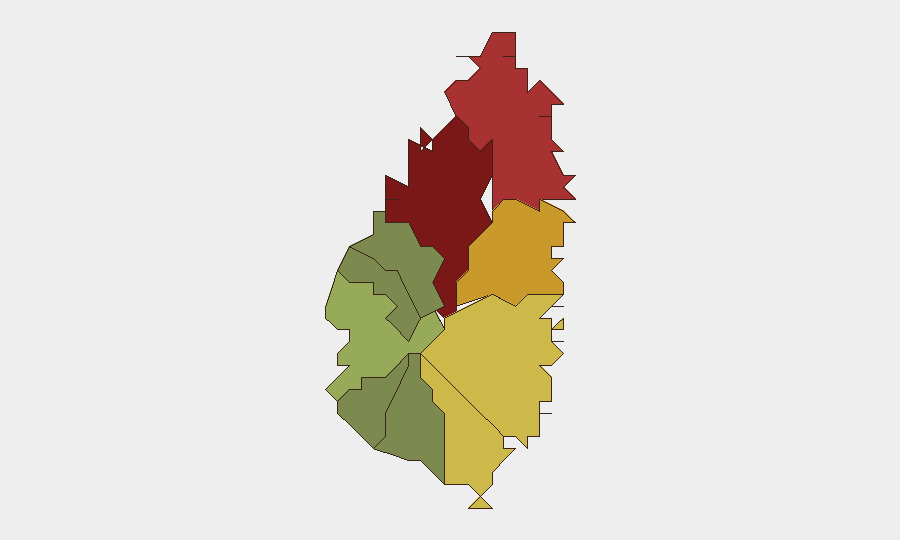
Saint Lucia remains a stable Caribbean jurisdiction with a composite threat score of 6 (rank #156 globally), reflecting low acute security incidents at the national level. No discrete security events have been confirmed in the past 24–48 hours. Risk remains concentrated in specific urban and commercial districts, particularly the capital and northern coastal zones, driven by persistent crime and gang activity rather than political instability or infrastructure disruption.
Key Developments
No confirmed security, crime, civil-unrest, or travel-risk incidents meeting current-event criteria (occurring within Saint Lucia on 2026-08-28 or 2026-08-29, corroborated by multiple sources) have been identified in the available research window.
*Background context:* Saint Lucian authorities have conducted ongoing asset-seizure operations targeting criminal networks in recent months, and geothermal and pipeline infrastructure upgrades are underway on the island; neither has generated acute security incidents in the past 48 hours. Teams should remain alert to ancillary disruptions from such projects but should not expect imminent operational impact.
Highest-Risk Areas
Castries (risk 95) and Gros Islet (risk 78) drive the majority of Saint Lucia's threat profile, reflecting concentrated gang and organized-crime activity in and around the capital and its northern commercial corridor. Dennery (72), Vieux Fort (68), and Micoud (65) constitute a secondary risk belt along the eastern and southern coasts, likely reflecting secondary gang territory and inter-gang violence vectors. Southern and western districts (Soufrière, Laborie, Choiseul, Anse La Raye, and Canaries) show substantially lower risk profiles (12–42), indicating that crime and security concerns are geographically dispersed but concentrated in urban transit hubs and ports.
How GeoBit Would Assist
Corporate security teams operating in Saint Lucia should employ AOI Monitoring & Early Warning (persistent watch on Castries, Gros Islet, and Dennery) to detect shifts in gang activity or crime patterns before they affect staff or operations. Intel Sweep and multi-language OSINT (including X/Twitter and Telegram monitoring) enable real-time detection of emerging criminal disputes or civil unrest that may not yet reach mainstream news. Routing & Network Analysis supports duty-of-care teams in identifying safer transit corridors for personnel in high-risk districts and planning evacuation routes.
7-Day Outlook
No acute escalation is anticipated in the next seven days. Underlying criminal activity and gang presence will likely remain steady in Castries and northern zones, with seasonal tourism and commercial activity providing routine security considerations. Teams should maintain standard risk-mitigation protocols and monitor intelligence feeds for any shift in gang-truce stability or emerging criminal-justice enforcement actions that could trigger localized disruption.
Highest-Risk Areas — Ranked
| # | State / Region | Risk |
|---|---|---|
| 1 | Castries | 95 |
| 2 | Gros Islet | 78 |
| 3 | Dennery | 72 |
| 4 | Vieux Fort | 68 |
| 5 | Micoud | 65 |
| 6 | Soufrière | 42 |
| 7 | Laborie | 38 |
| 8 | Choiseul | 35 |
| 9 | Anse La Raye | 28 |
| 10 | Canaries | 12 |
Sources
Previous Daily Briefs
A new Saint Lucia brief is written every day — each with its own risk map and downloadable CSV. Here's the last week; use the calendar to go further back.
- August 26, 2026
- August 24, 2026
- August 22, 2026
- August 20, 2026
- August 18, 2026
- August 16, 2026
- August 14, 2026
📅 Browse every day by calendar →
Highlighted days have a brief. Tap a day for that day's map & analysis, or “csv” for that day's dataset ($5).
Atlas — our AI intelligence desk — emails them this snapshot personally. Nothing else, no list.