Situation Summary
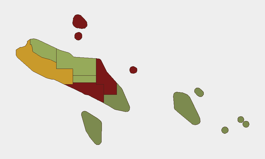
Solomon Islands remains a low-threat environment globally (rank #142; composite threat score 7) with no tracked acute security events as of 18 August 2026. The last 24–48 hours show routine infrastructure and border-management activity, a planned ordnance-disposal campaign, and increased regional maritime patrols—none indicative of instability. Risk concentrates in Honiara and nearby provinces (Guadalcanal, Malaita), driven by urbanization, maritime crime, and legacy UXO; outer provinces and Temotu present substantially lower threat profiles.
Key Developments
- Honiara, West Kola Ridge – 18 Aug 2026: Solomon Water shut off supply across multiple suburbs (West Kola, Kolale, Matariu, Mbua Valley, Tanuli, and others) following a burst water pipe; repair crews were on-site. Short-term basic-service disruption may elevate minor health and public-confidence risks if prolonged beyond 24–48 hours.
- Solomon Islands EEZ (maritime domain) – 18 Aug 2026: Australian Defence Force confirmed Operation Island Chief aerial surveillance, identifying 19 vessels of interest across 320,000 km² in coordination with Solomon Islands authorities and the Forum Fisheries Agency (based in Honiara). Activity reflects routine enforcement against illegal, unreported and unregulated (IUU) fishing and transnational maritime crime; no acute incidents reported.
- Shortland Islands, Lofung (Western Province) – 16–17 Aug 2026: Australia formally handed over the Lofung Border and Patrol Boat Outpost to the Solomon Islands Government. Co-located police, customs, biosecurity, and immigration agencies now strengthen border management with Papua New Guinea and South Bougainville; no unrest reported, but this shifts operational security posture along a traditionally sensitive maritime frontier.
- Western Province (Munda, Rendova, Kolombangara) – 15–27 Aug 2026 (ongoing): Royal Solomon Islands Police Force EOD unit conducting planned bomb-blast demolitions of World War II unexploded ordnance, 08:00–16:00 daily. Authorities issued cordoning warnings; no unplanned incidents or injuries reported as of 18 Aug.
- Choiseul Province – 19–24 Aug 2026 (upcoming): Similar planned UXO demolition operations scheduled (Tarekukure, Taro); cordons and daytime movement restrictions expected.
- Honiara (high-level visits) – 16–17 Aug 2026: Australian Deputy Prime Minister and Defence Minister held security and defence consultations with PM Matthew Wale and cabinet, concurrent with the Shortland outpost opening. No protests or disruptive civil unrest reported in connection with the visit.
- Regional strategic commentary – 18 Aug 2026: China's Foreign Ministry dismissed Palau's references to a recent ICBM test near Tuvalu and Solomon Islands as "groundless." This is diplomatic rhetoric; no direct in-country security incident resulted.
Highest-Risk Areas
Honiara (risk 92) and Guadalcanal (88) drive the national risk profile, followed closely by Malaita (85). These three account for urbanization, population density, maritime-crime exposure, and historical inter-communal tension. Western Province (72) carries elevated risk from border-trafficking activity and UXO legacy; Choiseul (58) adds UXO factors. Outer provinces (Makira-Ulawa, Rennell and Bellona, Temotu) present substantially lower composite risk, reflecting lower population density and reduced crime/maritime exposure.
How GeoBit Would Assist
Security teams should deploy AOI Monitoring & Early Warning on Honiara and maritime zones to detect escalation in crime, protest activity, or infrastructure crises before they spread. Maritime & Aviation tracking paired with OSINT fusion (multi-language, social-media sentiment analysis) provides early signals on transnational crime, IUU fishing networks, and political sentiment. Intel Sweep and conflict/border search capabilities track UXO disposal operations and cross-border trafficking patterns to refine duty-of-care protocols.
7-Day Outlook
Planned UXO demolitions (Western and Choiseul, through 27 Aug) will continue with localized cordons; no escalation expected if civilian cooperation holds. Water-supply restoration in Honiara should resolve within 48–72 hours, barring secondary complications. Maritime operations and border reinforcement indicate steady regional engagement; no political or civil instability signals have emerged in open reporting.
Highest-Risk Areas — Ranked
| # | State / Region | Risk |
|---|---|---|
| 1 | Honiara | 92 |
| 2 | Guadalcanal | 88 |
| 3 | Malaita | 85 |
| 4 | Western | 72 |
| 5 | Choiseul | 58 |
| 6 | Isabel | 52 |
| 7 | Central Province | 48 |
| 8 | Makira-Ulawa | 38 |
| 9 | Rennell and Bellona | 22 |
| 10 | Temotu | 18 |
Sources
Previous Daily Briefs
A new Solomon Islands brief is written every day — each with its own risk map and downloadable CSV. Here's the last week; use the calendar to go further back.
- August 16, 2026
- August 14, 2026
- August 12, 2026
- August 10, 2026
- August 8, 2026
- August 6, 2026
- August 5, 2026
📅 Browse every day by calendar →
Highlighted days have a brief. Tap a day for that day's map & analysis, or “csv” for that day's dataset ($5).
Atlas — our AI intelligence desk — emails them this snapshot personally. Nothing else, no list.