Situation Summary
Tanzania remains a moderate-risk environment (global rank #50, composite threat score 37) with no major security incidents confirmed in the last 24–48 hours. However, the country faces elevated protest and unrest risk over the coming weeks, triggered by political sensitivity around a newly signed U.S.–Tanzania health agreement and broader sovereignty concerns. Security force responses, potential roadblocks, and curfews are considered plausible; meanwhile, multiple active wildfires across the country present secondary humanitarian and infrastructure challenges.
Key Developments
- Dar es Salaam – 2 July 2026 – U.S.–Tanzania health MoU signed
The U.S. and Tanzania signed a five-year $3.1 billion bilateral health Memorandum of Understanding, committing $1.3 billion from the U.S. and $1.8 billion from Tanzania. The agreement has sparked political controversy in regional and local media over alleged access to sensitive biological data, framing the deal as a geopolitical competition and sovereignty issue with potential to drive demonstrations and public pressure on the government.
- Nationwide – Late June through early July – elevated protest and security-response risk
Official travel advisories warn that demonstrations and responses from security forces may occur across Tanzania over the next several weeks. Potential consequences include nationwide curfews, roadblocks, restricted movement, and security-force clashes; advisories recommend heightened situational awareness and contingency planning for travel disruptions.
- Multiple locations – Recent – active wildfires
Nine separate wildfire incidents have been recorded across Tanzania in recent days (events 1029268, 1029303, 1029269, 1029182, 1029157, 1029217, 1029122, 1029184, 1029042), affecting air quality, infrastructure, and civilian access to affected regions.
- No location-specific security incidents confirmed in last 24–48 hours
Open-web and social-media sources show no clearly verified, multi-source confirmed attacks, riots, kidnappings, or major crimes in the immediate past 48 hours.
Highest-Risk Areas
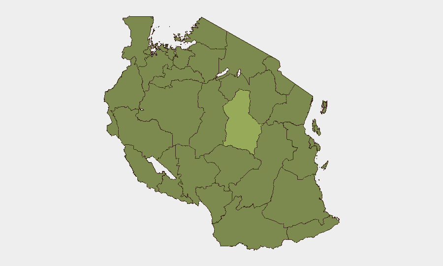
Dodoma Region carries significantly elevated risk (56.2) relative to all other regions, likely reflecting political sensitivity as the capital and administrative center during a period of government scrutiny over international agreements. Eleven other regions (Kigoma, Kagera, Mwanza, Geita, Shinyanga, Tabora, Katavi, Rukwa, Songwe, Mara, Simiyu) are ranked equally at 26.2, indicating that protest and civil-unrest risk is expected to be nationwide rather than geographically concentrated. Organizations with personnel or assets in or near Dodoma should prioritize real-time monitoring and contingency protocols; those in other regions should prepare for potential mobility and access restrictions but do not face markedly elevated localized security threats at this time.
How GeoBit Would Assist
Security teams should deploy Intel Sweep and multi-language OSINT fusion to track emerging protest organization, messaging, and actor networks across social media and Telegram, combined with sentiment and temporal analysis to detect acceleration of unrest planning. AOI Monitoring and Early Warning on Dodoma, major urban centers, and key infrastructure (ports, power, transport hubs) will provide real-time alert if demonstrations materialize or security-force activity escalates. Routing and Network Analysis capabilities enable contingency planning for alternative travel routes and safe-zone identification should curfews or roadblocks be imposed.
7-Day Outlook
Unrest risk is elevated but not imminent over the next 7 days, contingent on how quickly political opposition mobilizes around the health MoU. If large-scale protests do materialize, security-force responses and localized disruptions are likely; wildfire activity is expected to persist, adding strain to emergency response and potentially complicating access to affected areas. Organizations should activate duty-of-care protocols, increase monitoring frequency, and confirm staff location and communication procedures by end of business today.
Highest-Risk Areas — Ranked
| # | State / Region | Risk |
|---|---|---|
| 1 | Dodoma Region | 56.2 |
| 2 | Kigoma Region | 26.2 |
| 3 | Kagera | 26.2 |
| 4 | Mwanza Region | 26.2 |
| 5 | Geita | 26.2 |
| 6 | Shinyanga Region | 26.2 |
| 7 | Tabora Region | 26.2 |
| 8 | Katavi Region | 26.2 |
| 9 | Rukwa Region | 26.2 |
| 10 | Songwe Region | 26.2 |
| 11 | Mara Region | 26.2 |
| 12 | Simiyu | 26.2 |
Sources
Previous Daily Briefs
A new Tanzania brief is written every day — each with its own risk map and downloadable CSV. Here's the last week; use the calendar to go further back.
📅 Browse every day by calendar →
Highlighted days have a brief. Tap a day for that day's map & analysis, or “csv” for that day's dataset ($5).
Atlas — our AI intelligence desk — emails them this snapshot personally. Nothing else, no list.