Situation Summary
Togo remains a low-threat environment globally (rank #85, composite score 19) with no tracked major incidents as of 15 August 2026. However, subnational risk is heavily concentrated in the north—Savanes and Kara regions face markedly elevated threat levels driven by cross-border instability, organized crime, and petty official misconduct. The recent destruction of nearly 1,000 artisanal firearms and arrest of organized burglary suspects suggest moderately active law enforcement, though credibility gaps persist (documented gendarme racketeering on inter-regional roads).
Key Developments
- No credible, cross-verified security or risk incidents reported within the last 24–48 hours (14–15 August 2026). Available web research and indexed media do not surface incident-level events meeting location, date, and verification thresholds for this window.
- SYAPAL union strike notice (11 August, ongoing impact). A 72-hour strike affecting cargo handling and port operations at Lomé commenced 11 August. While labor-driven, this may constrain supply-chain logistics and create secondary bottlenecks for corporate operations dependent on port throughput.
- Documented gendarme racketeering (8 August, Gbatope-Davedi road). Two uniformed officers engaged in nocturnal fee extraction from vehicular traffic, indicating persistent informal taxation and rule-of-law vulnerability on inter-regional corridors. Pattern suggests recurring risk to overland supply routes and personnel transit.
- Organized burglary network disrupted (8 August, Kpogan). Arrest of three suspected members following a break-in at the MATW Islamic center. Reflects active organized property crime but also functional police response capacity.
- Firearms destruction operation (7 August, Lomé). CNLPAL oversaw destruction of ~1,000 seized artisanal weapons. While a positive indicator of state disarmament effort, the volume suggests ongoing localized weapons production and circulation, particularly in northern regions.
Highest-Risk Areas
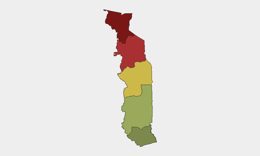
Savanes Region (risk 92) and Kara Region (risk 78) dominate the threat landscape and are the clear operational priorities for security teams. Both border Burkina Faso and are exposed to cross-border smuggling, jihadist infiltration networks, and ungoverned space effects. Centrale Region (risk 65) presents secondary concern. By contrast, Maritime Region (risk 28), anchored by Lomé's relatively secure urban core, remains substantially lower-risk despite localized street crime and the current port labor action. Risk mitigation should prioritize personnel and asset concentration in the south and sea-facing zones; northern postings require elevated security protocols, local liaison, and contingency routing.
How GeoBit Would Assist
Security teams should deploy AOI Monitoring & Early Warning with persistent geofenced alerts around Savanes, Kara, and key cross-border checkpoints (Burkina Faso, Ghana, Benin borders) to detect emerging trafficking, militant activity, or civil unrest before operational impact. Multi-language OSINT Fusion (French-language regional media, social media geofencing, and Telegram monitoring) will surface locally-reported incidents and labor or political signals 24–48 hours ahead of international indexing. Routing & Network Analysis enables real-time alternative-corridor planning to avoid documented racketeering zones and strike-affected logistics hubs (Lomé port).
7-Day Outlook
The port strike is expected to resolve or stabilize within the announced 72-hour window, likely by 14 August evening, though secondary delays are common. No major political or security triggers are forecasted over the next week; however, the persistent northern regional risks (Savanes, Kara) remain baseline concerns requiring continuous monitoring rather than acute escalation.
Highest-Risk Areas — Ranked
| # | State / Region | Risk |
|---|---|---|
| 1 | Savanes Region | 92 |
| 2 | Kara Region | 78 |
| 3 | Centrale Region | 65 |
| 4 | Plateaux Region | 45 |
| 5 | Maritime Region | 28 |
Sources
Previous Daily Briefs
A new Togo brief is written every day — each with its own risk map and downloadable CSV. Here's the last week; use the calendar to go further back.
- August 13, 2026
- August 11, 2026
- August 9, 2026
- August 7, 2026
- August 6, 2026
- August 4, 2026
- August 3, 2026
📅 Browse every day by calendar →
Highlighted days have a brief. Tap a day for that day's map & analysis, or “csv” for that day's dataset ($5).
Atlas — our AI intelligence desk — emails them this snapshot personally. Nothing else, no list.