Situation Summary
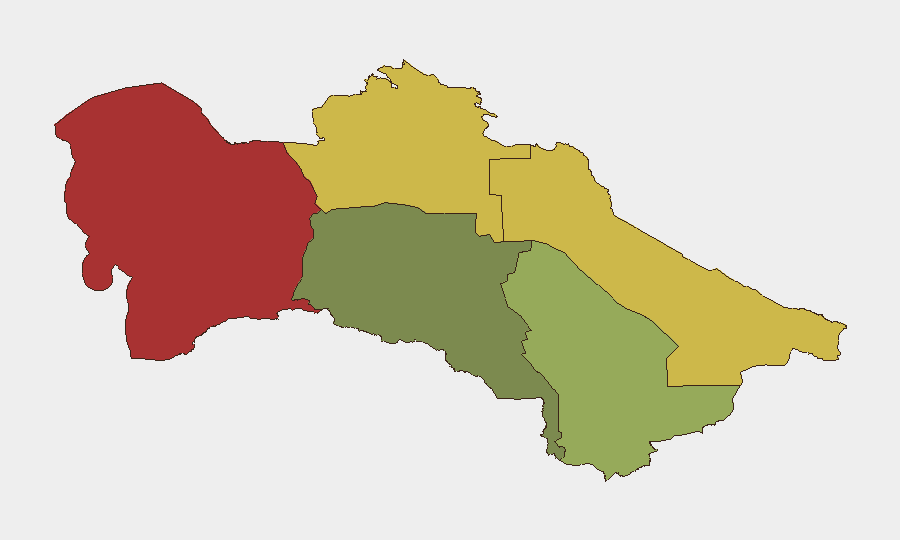
Turkmenistan maintains a stable overall security environment with no significant incidents reported in the past 24–48 hours. The country ranks #197 globally on GeoBit's threat index, reflecting low-frequency event activity and a restrictive information environment that limits real-time reporting of security developments. Sub-national risk concentration in the Balkan and Lebap regions indicates persistent localized vulnerabilities, likely linked to border permeability and smuggling activity rather than acute instability.
Key Developments
No verifiable security, civil-unrest, crime, political-instability, infrastructure, or travel-risk incidents meeting multi-source confirmation standards were identified in Turkmenistan during the 24–48 hour window (2026-07-01 to 2026-07-02). Turkmenistan's highly restricted media and communications environment, combined with limited independent reporting channels, constrains real-time event visibility. GeoBit's OSINT monitoring (X/Twitter, Telegram, open web news) detected no discrete incidents of operational significance during the specified timeframe.
Highest-Risk Areas
The Balkan Region (risk score 78) and Lebap Region (risk score 68) dominate sub-national threat concentration, reflecting their proximity to the Caspian Sea, Iranian border, and Uzbek frontier—corridors historically associated with smuggling, irregular migration, and low-level cross-border trafficking. Dashoguz Region (risk 62) follows as the third-highest risk zone, likely due to its northern border position and limited state capacity for control. By contrast, Ashgabat City (risk 18) remains the lowest-risk jurisdiction, consistent with heavy security-force presence and centralized state oversight. Corporate assets in the peripheral regions face elevated exposure to supply-chain disruption, unofficial taxation, and irregular law-enforcement activity, while the capital maintains predictable operational conditions.
How GeoBit Would Assist
Teams managing personnel or assets in Turkmenistan should deploy AOI Monitoring & Early Warning on Balkan and Lebap regions to detect emerging incidents or unusual movement patterns in near-real time, coupled with OSINT fusion (multi-language search, Telegram & X/Twitter monitoring) to capture signal in the restrictive information environment. Routing & Network Analysis capability enables identification of alternative logistics and personnel routes that avoid high-risk corridors; Satellite & Imagery analysis on border crossing points and port facilities provides independent verification of supply-chain and transit disruption risk. Regular Intel Sweep updates flag any shifts in regime stability or enforcement posture affecting duty-of-care compliance.
7-Day Outlook
No acute threat escalation is anticipated over the next seven days. Structural risks—limited media freedom, border control inconsistency, and informal enforcement practices—remain steady-state. Continued monitoring of Balkan and Lebap regions for any shift in trafficking activity or cross-border incident frequency is recommended as a leading indicator of regional destabilization.
Highest-Risk Areas — Ranked
| # | State / Region | Risk |
|---|---|---|
| 1 | Balkan Region | 78 |
| 2 | Lebap Region | 68 |
| 3 | Dashoguz Region | 62 |
| 4 | Mary Region | 42 |
| 5 | Ahal Region | 35 |
| 6 | Ashgabat City | 18 |
Sources
Previous Daily Briefs
A new Turkmenistan brief is written every day — each with its own risk map and downloadable CSV. Here's the last week; use the calendar to go further back.
📅 Browse every day by calendar →
Highlighted days have a brief. Tap a day for that day's map & analysis, or “csv” for that day's dataset ($5).