Situation Summary
Ukraine remains under sustained conventional military pressure, with Russian drone and missile strikes intensifying across multiple oblasts over the past 48 hours. At least 16 civilians have been killed and dozens injured in attacks spanning Zaporizhzhia, Sumy, Odesa, Kharkiv, and Dnipropetrovsk oblasts since 22 June. Ukrainian countermeasures against Russian-occupied Crimean infrastructure are degrading critical services to occupied territories and raising maritime risk in the Black Sea. The composite threat environment shows no signs of de-escalation.
Key Developments
- Sumy oblast (near Sumy city) – 22 June, early morning: Russian drone strike on a residential home killed three civilians including a 13-year-old boy, his father, and a 73-year-old grandmother.
- Zaporizhzhia city – night of 22–23 June: Russian drone and missile strikes on residential areas killed at least two civilians and injured seven; multiple homes reported on fire.
- Kryvyi Rih, Dnipropetrovsk oblast – 23 June morning: Russian cluster-munitions missile strike on an industrial facility killed three and injured more than 20, with several in critical condition.
- Odesa oblast – 22 June evening: Russian Iskander ballistic missile strike killed one person and injured three.
- Kharkiv oblast – night of 22–23 June: Russian strikes wounded at least six civilians in overnight attacks.
- Crimea (Kerch area and North Crimean Canal) – 23 June: Ukrainian drone strikes against railway bridge and Kerch power plant caused widespread power outages (up to 50% of peninsula) and suspension of civilian fuel sales; Kerch Bridge briefly closed.
- Black Sea – night of 22–23 June: Russian drones attacked Turkish-flagged dry cargo vessel *Victress*, killing an Egyptian crew member and forcing evacuation of remaining crew into lifeboats.
- Kyiv city – 22 June evening: Large-scale Russian aerial attack prompted air-raid alert; city sustained minimal damage relative to regional strikes.
Highest-Risk Areas
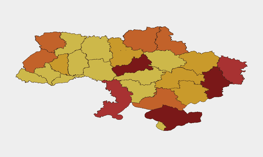
Cherkasy and Kyiv oblasts rank highest (composite scores 100 and 95.3), driven by proximity to active military operations and Russia's demonstrated capability to strike civilian infrastructure with precision munitions. The eastern and southern oblasts—Donetsk, Luhansk, Kherson, Zaporizhzhia, and Odesa—remain under sustained attack pressure; Sumy and Kharkiv in the northeast show elevated risk from cross-border drone and missile strikes. Crimea's ranking reflects both active military operations and critical infrastructure vulnerability to Ukrainian strikes, which disrupt services and complicate civilian movement.
How GeoBit Would Assist
Security and duty-of-care teams with personnel or assets in Ukraine would employ Battle Mapping and Force Structure analysis to track real-time Russian strike patterns and Ukrainian counter-operations, AOI Monitoring & Early Warning for persistent watch on high-risk oblasts (Cherkasy, Kyiv, Zaporizhzhia, Sumy, Kharkiv) with automated alerting on new attack clusters, and Maritime & Aviation Tracking to monitor drone activity and maritime incidents affecting supply routes and personnel movement. GIS & Spatial Analysis and Satellite & Imagery capabilities support damage assessment and infrastructure vulnerability mapping, while Network & Actor Analysis clarifies command-and-control patterns to anticipate targeting priorities.
7-Day Outlook
Russian strike operations are likely to persist at current or elevated tempo, targeting both military-industrial and civilian infrastructure across multiple oblasts. Ukrainian counter-strikes on Crimean infrastructure may provoke further Russian retaliation. Maritime risk in the Black Sea remains elevated; commercial shipping should anticipate continued drone attacks independent of flag state.
Highest-Risk Areas — Ranked
| # | State / Region | Risk |
|---|---|---|
| 1 | Cherkasy Oblast | 100 |
| 2 | Kyiv | 95.3 |
| 3 | Autonomous Republic of Crimea | 86.4 |
| 4 | Donetsk Oblast | 81.9 |
| 5 | Luhansk Oblast | 76.5 |
| 6 | Odesa Oblast | 76.3 |
| 7 | Sumy Oblast | 74.7 |
| 8 | Kherson Oblast | 74.7 |
| 9 | Lviv Oblast | 74.6 |
| 10 | Volyn Oblast | 74.3 |
| 11 | Chernihiv Oblast | 73.4 |
| 12 | Kharkiv Oblast | 71.7 |
Sources
Previous Daily Briefs
A new Ukraine brief is written every day — each with its own risk map and downloadable CSV. Here's the last week; use the calendar to go further back.
📅 Browse every day by calendar →
Highlighted days have a brief. Tap a day for that day's map & analysis, or “csv” for that day's dataset ($5).