Situation Summary
Burkina Faso remains the 25th highest-threat country globally (composite score 70) with the North region substantially elevated above the rest of the country (risk 79 vs. countrywide 70). The state continues to face persistent armed group activity, particularly in the Sahel and northern zones, alongside ongoing media regulation tensions and sporadic diplomatic friction. The security environment shows no sign of acute deterioration in the past 48 hours, but structural insurgent pressure and governance constraints remain firm.
Key Developments
No specific security incidents have been confirmed in Burkina Faso during the 24–48 hours preceding 2026-06-19. Open-source reporting within this window identifies only:
- Ghana–Burkina Faso border security talks (week-long initiative, dates not precisely timestamped in available sources) focused on cross-border cooperation, but no discrete incident, disruption, or attack reported at these talks.
- Regional analytical coverage (e.g., Stimson Center North Africa outlook, 17 June) positioning Burkina Faso within Sahel counterterrorism trends, but these are contextual assessments, not new events.
- Ongoing media regulation activity (e.g., regulator enforcement against broadcasters), but timestamps are unclear and cross-referenced reporting suggests these are not developments of the last 48 hours.
Corporate security teams should note that absence of reported incidents does not indicate reduced threat; rather, it reflects the current state of open-source confirmation. Persistent armed group operations, roadblock risks, and checkpoint delays in northern and Sahel regions remain routine hazards.
Highest-Risk Areas
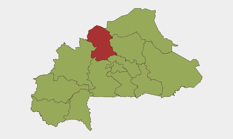
The North region dominates risk (score 79), driven by sustained armed group presence, military operations, and civilian displacement. The Sahel region (score 54) follows as the second-priority area, characterized by cross-border movement of insurgent groups and intercommunal tensions. The remaining nine regions cluster at score 49, indicating a broad baseline of elevated but less acute risk; however, any of these zones—particularly Upper-Basins, Boucle du Mouhoun, Central-East, and East—can experience rapid escalation linked to armed group activity or intercommunal conflict. The spatial disparity (North 79 vs. Centre 49) suggests that while Ouagadougou and central provinces maintain stability relative to the north, no region is classified as low-risk.
How GeoBit Would Assist
Security teams monitoring personnel or assets in Burkina Faso should leverage AOI Monitoring & Early Warning to establish persistent watch on the North and Sahel regions and receive alerts on incident onset. Intel Sweep, X/Twitter OSINT, and multi-language search provide daily corroboration of armed group statements, military operations, and checkpoint activity. Routing & Network Analysis enables real-time identification of safe transit corridors and avoidance of high-risk checkpoints and roadblocks. Conflict & Military force-structure tracking and satellite imagery analysis support understanding of shifting armed group deployments and military posture changes that may precede escalation.
7-Day Outlook
The security trajectory over the next week is expected to remain stable at current elevated levels, with no acute catalyst signaling rapid deterioration. Routine armed group operations in the North and Sahel, checkpoint delays, and administrative friction should be anticipated. Any substantive change in military operations, cross-border activity, or diplomatic rupture would warrant immediate re-assessment and circulation of updated routing and personnel guidance.
Highest-Risk Areas — Ranked
| # | State / Region | Risk |
|---|---|---|
| 1 | North | 79 |
| 2 | Sahel | 54 |
| 3 | Upper-Basins | 49 |
| 4 | Boucle du Mouhoun | 49 |
| 5 | Central-West | 49 |
| 6 | Central-South | 49 |
| 7 | Central-East | 49 |
| 8 | Waterfalls | 49 |
| 9 | Southwest | 49 |
| 10 | Central-North | 49 |
| 11 | East | 49 |
| 12 | Centre | 49 |
Sources
Previous Daily Briefs
A new Burkina Faso brief is written every day — each with its own risk map and downloadable CSV. Here's the last week; use the calendar to go further back.
📅 Browse every day by calendar →
Highlighted days have a brief. Tap a day for that day's map & analysis, or “csv” for that day's dataset ($5).