Situation Summary
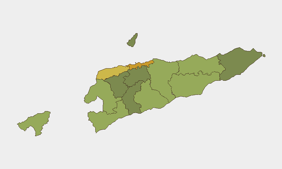
East Timor remains a low-threat environment globally (rank #180, composite score 2.5) with no documented security incidents, civil unrest, or infrastructure disruptions in the last 24–48 hours. The country continues normal commercial and public activity, including routine MSME and technology events in the capital. Risk concentration is marked geographically: the capital Dili and western border regions (Liquiçá, Cova Lima, Bobonaro) carry materially higher composite threat scores than the eastern and southern districts.
Key Developments
- 2026-07-09 · Dili region: A demand-related incident involving a school and Portuguese-language stakeholders was flagged in event signals. No corroborating open-source reporting has confirmed scale, outcome, or current status; this signal warrants monitoring but should not be treated as an active security event without further verification.
- No acute incidents documented: Live web research across news, institutional sources, and regional feeds yielded no reports of protests, clashes, crime spikes, political instability, or transport/infrastructure disruptions within the specified 24–48 hour window.
- Commercial activity ongoing: Event activity at Timor Plaza (Dili) and broader MSME sector engagement reflect baseline operational continuity with no indicators of heightened security conditions.
Highest-Risk Areas
Dili (risk 72) dominates the threat profile as the capital and primary urban center, followed by a distinct western risk corridor spanning Liquiçá (62), Cova Lima (55), and Bobonaro (53)—all border or near-border districts with historical sensitivities and lower state capacity. Baucau (58) in the northeast represents a secondary concentration point. Eastern and southern districts (Aileu, Ermera, Ainaro, Manatuto, Viqueque) carry materially lower composite scores, reflecting calmer operating environments. Corporate and expat presence clusters in Dili; duty-of-care teams should maintain elevated baseline awareness in the capital and western zones.
How GeoBit Would Assist
Teams operating in East Timor should deploy AOI Monitoring & Early Warning on Dili and border districts (Liquiçá, Cova Lima) to detect emerging unrest, protest activity, or civil tension before escalation. OSINT fusion (X/Twitter, Telegram, local news feeds, sentiment & temporal analysis) will surface community-level signals, labor actions, or localised disputes ahead of mainstream reporting. Routing & Network Analysis supports real-time alternative-route planning for staff mobility in high-risk western zones and Dili, particularly during periods of heightened activity around schools or government institutions.
7-Day Outlook
No acute threat trajectory change is indicated for the near term. Baseline low-risk posture is expected to persist; however, the school-related demand signal in Dili warrants 48–72 hour monitoring for escalation or cascading activity. Teams should maintain standard duty-of-care protocols, with emphasis on communications redundancy and situational awareness in Dili and western border regions, where composite risk remains elevated relative to national average.
Highest-Risk Areas — Ranked
| # | State / Region | Risk |
|---|---|---|
| 1 | Dili | 72 |
| 2 | Liquiçá | 62 |
| 3 | Baucau | 58 |
| 4 | Cova Lima | 55 |
| 5 | Bobonaro | 53 |
| 6 | Oecussi-Ambeno | 48 |
| 7 | Manufahi | 45 |
| 8 | Viqueque | 42 |
| 9 | Manatuto | 40 |
| 10 | Ainaro | 38 |
| 11 | Ermera | 36 |
| 12 | Aileu | 32 |
Sources
Previous Daily Briefs
A new East Timor brief is written every day — each with its own risk map and downloadable CSV. Here's the last week; use the calendar to go further back.
📅 Browse every day by calendar →
Highlighted days have a brief. Tap a day for that day's map & analysis, or “csv” for that day's dataset ($5).
Atlas — our AI intelligence desk — emails them this snapshot personally. Nothing else, no list.