Situation Summary
Grenada remains a low-threat environment with a composite global ranking of #164 and no tracked security events as of 16 August 2026. The security picture is dominated by ongoing investigations into three separate water-related fatalities occurring between 13–14 August, plus an active search operation for a missing American tourist since 22 July. No violent crime, civil unrest, political instability, or infrastructure disruption has been reported in the last 24–48 hours.
Key Developments
- No new security incidents documented in Grenada for 15–16 August 2026. Open-source intelligence and web monitoring have identified no confirmed shootings, armed robberies, gang activity, protests, strikes, or infrastructure failures within the last 24–48 hours.
- Ongoing police investigation into maritime fatality at Grand Anse Beach, St. George (incident: 8 August, investigation active through 15 August). Two women died following contact with a charter boat's propeller during Spicemas Carnival; the vessel's captain has been detained, and the case remains under active investigation with no charges confirmed as of 15 August.
- Active search and investigation for missing U.S. tourist, Elizabeth Waddell, 43 (missing since 22 July, search operations updated through 16 August). Royal Grenada Police Force continues dive-team, drone, and dog-assisted searches; husband has stated drowning appears most likely; case remains open.
- Two child fatalities under police investigation in St. Andrew Parish (13–14 August). A 2-year-old boy was found unresponsive in Burn Pan River, Telescope, on 13 August; a young boy from Telescope died in the Boucherie area near Simon on 14 August. Both circumstances remain under investigation; incidents are classified as accidental drowning investigations rather than crime.
Highest-Risk Areas
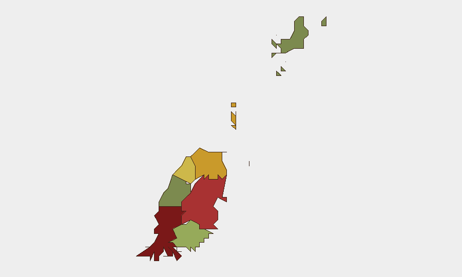
Saint George (risk score 92) and Saint Andrew (78) dominate Grenada's sub-national risk profile, driven primarily by recent fatalities in water settings and ongoing police investigations rather than violent crime or unrest. Saint George encompasses the capital and tourism hub (Grand Anse Beach, site of the 8 August maritime incident); Saint Andrew has experienced two child drowning incidents within 24 hours (13–14 August). Saint Patrick (71) and Saint Mark (64) carry moderate scores, while Carriacou and Petite Martinique remain lowest-risk (12), reflecting their smaller populations and distance from central urban and tourism activity. Current risk is concentrated around water-safety and investigative attention rather than criminal or political instability.
How GeoBit Would Assist
A corporate security or duty-of-care team with personnel or assets in Grenada would deploy AOI Monitoring & Early Warning on high-risk parishes (St. George, St. Andrew) to detect emerging incidents, police operations, or travel disruptions in real time. OSINT fusion & corroboration across local media, official police statements, and social platforms would provide rapid confirmation of new incidents and distinguish accidental/investigative matters from crime or unrest. Maritime & Aviation tracking capabilities would offer situational awareness on charter operations and coastal incidents affecting tourism and expatriate communities, particularly around Grand Anse and other popular beach venues.
7-Day Outlook
No immediate escalation in security risk is anticipated. Ongoing investigations into the water-related fatalities and missing-person search will likely continue without major operational disruption to transport or commerce. Maritime and recreational water-safety scrutiny may persist, warranting advisory updates for staff and visitors engaging in coastal activities.
Highest-Risk Areas — Ranked
| # | State / Region | Risk |
|---|---|---|
| 1 | Saint George | 92 |
| 2 | Saint Andrew | 78 |
| 3 | Saint Patrick | 71 |
| 4 | Saint Mark | 64 |
| 5 | Saint David | 52 |
| 6 | Saint John | 38 |
| 7 | Carriacou and Petite Martinique | 12 |
Sources
Previous Daily Briefs
A new Grenada brief is written every day — each with its own risk map and downloadable CSV. Here's the last week; use the calendar to go further back.
- August 14, 2026
- August 12, 2026
- August 10, 2026
- August 8, 2026
- August 6, 2026
- August 5, 2026
- August 4, 2026
📅 Browse every day by calendar →
Highlighted days have a brief. Tap a day for that day's map & analysis, or “csv” for that day's dataset ($5).
Atlas — our AI intelligence desk — emails them this snapshot personally. Nothing else, no list.