Situation Summary
Guinea-Bissau remains in a low-frequency threat environment with no verified security incidents, armed violence, civil unrest, or infrastructure disruption reported in the last 24–48 hours. The most recent significant political development—the July 10 military court order remanding opposition leader Domingos Simões Pereira to pre-trial detention—has not triggered observable public unrest, roadblocks, curfews, or travel restrictions. Overall security conditions are assessed as calm and stable, though underlying political tension persists around the detention and structural vulnerabilities (coup dynamics, governance instability) remain.
Key Developments
- National (Guinea-Bissau) — July 15–16, 2026: No verified incidents of armed violence, civil unrest, major crime, or infrastructure disruption reported in the last 24–48 hours; security environment characterized as low-frequency and stable.
- Bissau Autonomous Sector — July 10, 2026 (background context, not current): Military court ordered opposition leader Domingos Simões Pereira back into pre-trial detention on coup-related and financial-crime accusations; transferred under heavy military escort to Segunda Esquadra prison. This event, while politically significant, has not generated observable public security incidents or mobility restrictions as of July 16.
- National (Guinea-Bissau) — July 15–16, 2026: No protests, roadblocks, curfews, or travel-disrupting security operations corroborated nationwide despite political tensions around the opposition detention.
- National (Guinea-Bissau) — ongoing since early 2026: Heightened traffic enforcement and vehicle roadworthiness checks continue; no new enforcement crackdowns or specific operations reported in the last 48 hours.
Highest-Risk Areas
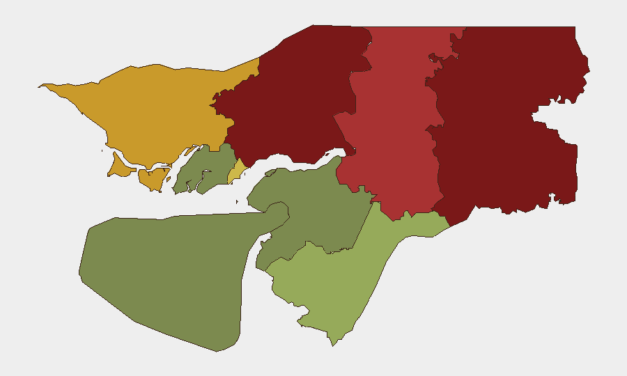
Gabu Region (risk 92) and Oio Region (risk 85) are the highest-risk sub-national areas and drive the country's composite threat score. Both regions border Senegal and have historically faced trafficking, arms smuggling, and cross-border movement pressures; Gabu in particular has been flagged for militia activity and governance fragility. Bafatá (78) and Cacheu (72) regions present similar border-transit and trafficking concerns. Bissau Autonomous Sector (68), despite hosting the capital and largest security apparatus, ranks fifth due to underlying political instability and detention operations. Risk in the southern regions (Tombali, Quinara, Biombo) remains significantly lower.
How GeoBit Would Assist
Security and duty-of-care teams should use GeoBit's AOI Monitoring & Early Warning to maintain persistent watch on high-risk regions (Gabu, Oio, Bafatá, Cacheu) for sudden shifts in political or armed activity. Intel Sweep and multi-language OSINT (X/Twitter, Telegram, regional media, radio SIGINT) will provide real-time detection of unrest, roadblock deployment, or mobility restrictions before they impact personnel or supply chains. GIS & Spatial Analysis and alternative route/journey planning enable rapid re-routing of movements and asset transport away from emerging hotspots, particularly in border areas where trafficking and enforcement operations may intensify.
7-Day Outlook
No imminent escalation is forecast; the political detention and absence of triggering unrest suggest a consolidation phase rather than acute instability. Structural risks—governance fragility, coup-related tensions, cross-border trafficking—remain present and warrant sustained monitoring. Near-term focus should be on regional volatility in Gabu and Oio rather than capital-centered disruption.
Highest-Risk Areas — Ranked
| # | State / Region | Risk |
|---|---|---|
| 1 | Gabu Region | 92 |
| 2 | Oio Region | 85 |
| 3 | Bafatá Region | 78 |
| 4 | Cacheu Region | 72 |
| 5 | Bissau Autonomous Sector | 68 |
| 6 | Tombali Region | 45 |
| 7 | Quinara Region | 38 |
| 8 | Biombo Region | 32 |
| 9 | Bolama Region | 15 |
Sources
Previous Daily Briefs
A new Guinea-Bissau brief is written every day — each with its own risk map and downloadable CSV. Here's the last week; use the calendar to go further back.
📅 Browse every day by calendar →
Highlighted days have a brief. Tap a day for that day's map & analysis, or “csv” for that day's dataset ($5).
Atlas — our AI intelligence desk — emails them this snapshot personally. Nothing else, no list.