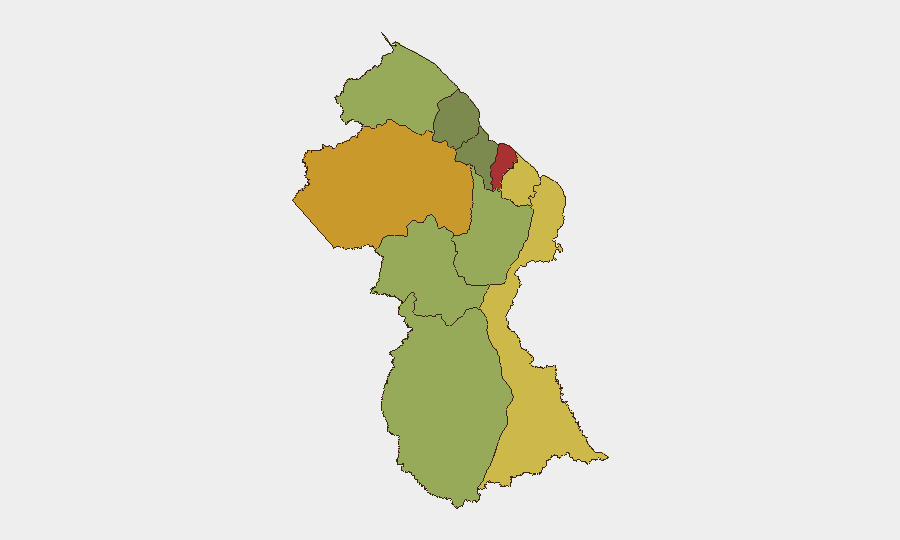
Situation Summary
Guyana remains at low global security risk (rank #71, composite threat score 16) with no verified incident-specific security events recorded in the past 24–48 hours. Two diplomatic signals involving Colombia and Panama were logged on 4–5 July, but these reflect state-level demands and diplomatic disapproval rather than active conflict or instability affecting corporate assets or personnel. The standing risk profile—driven by porous land borders, criminal networks, and regional tensions—remains unchanged; no deterioration is evident from current reporting.
Key Developments
- 2026-07-05 · Colombia–Government demand signal – No verifiable incident location or operational detail available; likely diplomatic or trade-related rather than security incident.
- 2026-07-04 · Guyana–Panama disapproval signals (two instances) – State-level diplomatic friction noted; no reported impact on internal stability, port operations, or corporate activity.
- Standing border-security concern (Venezuela–Guyana frontier) – U.S. Embassy advisories confirm the land border remains unsecured and vulnerable to criminal exploitation, but this is an ongoing structural risk assessment, not a new incident in the reporting period.
- No verified incidents in Demerara-Mahaica, Cuyuni-Mazaruni, or other high-risk regions – Despite elevated composite threat scores in coastal and interior mining zones, web research identified no specific crime, civil unrest, or infrastructure failures in the last 24–48 hours.
Highest-Risk Areas
Demerara-Mahaica (risk 78) and Cuyuni-Mazaruni (risk 72) are the primary drivers of national risk, reflecting the concentration of economic activity, urban density, and informal mining and narcotics transit in the coastal zone and interior hinterland. Mahaica-Berbice (65) and East Berbice-Corentyne (62) remain elevated, likely due to historical gang and organized-crime activity along the Corentyne River border with Suriname. These four regions account for the majority of reported security incidents and warrant priority monitoring by corporate teams with personnel or assets in or transiting through those areas; interior mining zones and border corridors present the highest duty-of-care exposure.
How GeoBit Would Assist
Security teams should deploy AOI Monitoring & Early Warning to track Demerara-Mahaica and Cuyuni-Mazaruni for emerging gang activity, protests, or infrastructure disruptions affecting supply chains or personnel movement. Network & Actor Analysis and multi-language OSINT fusion (X/Twitter, Telegram, local news feeds) would provide early signals of criminal or political shifts before they escalate to incident level. Routing & Network Analysis capabilities enable security teams to plan alternative supply and personnel routes around high-risk corridors and border zones in real time.
7-Day Outlook
No imminent security escalation is forecast for the week of 6–12 July. Diplomatic friction with Panama and Colombia should be monitored for trade or maritime impacts but carries low near-term risk to ground operations. Persistent structural vulnerabilities—porous borders, mining-zone criminality, and cross-border narcotics activity—remain the primary concern; localized crime and organized-activity risks in coastal and interior zones are expected to continue at current baseline levels absent new triggering events.
Highest-Risk Areas — Ranked
| # | State / Region | Risk |
|---|---|---|
| 1 | Demerara-Mahaica | 78 |
| 2 | Cuyuni-Mazaruni | 72 |
| 3 | Mahaica-Berbice | 65 |
| 4 | East Berbice-Corentyne | 62 |
| 5 | Upper Demerara-Berbice | 58 |
| 6 | Potaro-Siparuni | 48 |
| 7 | Barima-Waini | 45 |
| 8 | Upper Takutu-Upper Essequibo | 42 |
| 9 | Pomeroon-Supenaam | 38 |
| 10 | Essequibo Islands | 35 |
Sources
Previous Daily Briefs
A new Guyana brief is written every day — each with its own risk map and downloadable CSV. Here's the last week; use the calendar to go further back.
📅 Browse every day by calendar →
Highlighted days have a brief. Tap a day for that day's map & analysis, or “csv” for that day's dataset ($5).
Atlas — our AI intelligence desk — emails them this snapshot personally. Nothing else, no list.