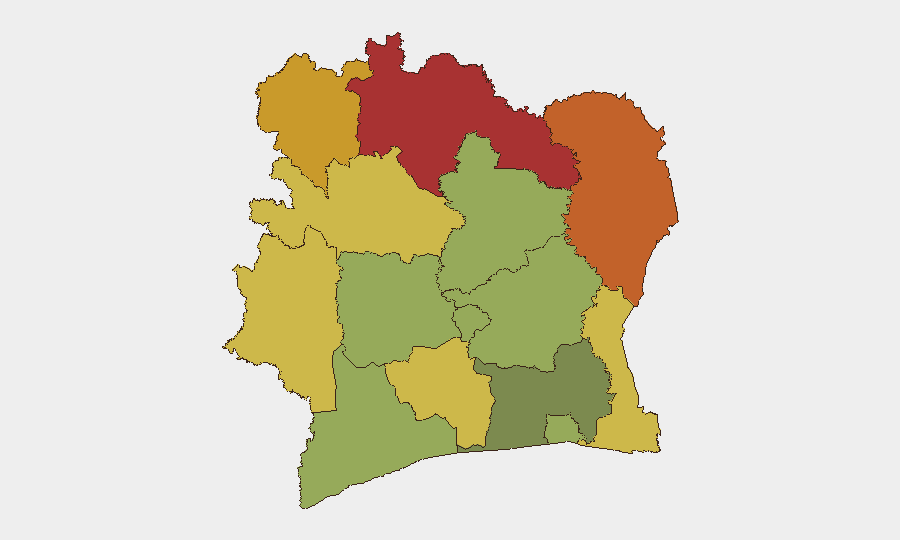
Situation Summary
Ivory Coast remains broadly stable at a national level, with a composite threat score of 17 and no tracked discrete security events in the current reporting window. However, risk is heavily concentrated in the northern and northeastern districts—Savanes, Zanzan, and Denguélé—where composite scores range from 72 to 78, reflecting longstanding vulnerabilities to transnational crime, border instability, and militant activity. The security posture in Abidjan and southern zones remains relatively controlled, though infrastructure deficits and localized crime persist.
Key Developments
No verified security, conflict, or civil-unrest incidents have been confirmed within the last 24–48 hours. Routine web monitoring identified one unverified report of an accidental explosion at a Customs facility in Ferkessédougou (date not confirmed in available sources), but insufficient detail and timing confirmation prevent operational assessment. Prior events—including a major drug seizure in Assinie on 8 July and ongoing water-supply disruptions in Yopougon—fall outside the current window and should be treated as background context rather than active developments.
Highest-Risk Areas
Northern districts drive the country's threat profile. Savanes (risk 78), Zanzan (75), and Denguélé (72) districts form a contiguous high-risk zone along the Mali and Burkina Faso borders, where porous frontier controls, militant transit, and organized-crime networks create persistent vulnerabilities. Comoé and Montagnes districts (70 and 68 respectively) extend this risk into the northwest. Southern and central zones—including Abidjan (45) and the Vallée du Bandama (55)—present significantly lower composite scores, though localized crime and infrastructure gaps remain operational considerations for resident and transiting personnel.
How GeoBit Would Assist
Security teams with personnel or assets in Ivory Coast should employ AOI (Area-of-Interest) Monitoring & Early Warning on the high-risk northern districts to detect emerging militant activity, roadblocks, or border incidents in near-real time. Multi-language OSINT—including X/Twitter, Telegram, and local media feeds—cross-referenced with sentiment and temporal analysis will establish whether the reported Ferkessédougou explosion and other fragmentary reports represent operational threats or noise. Routing & Network Analysis capabilities enable identification of secure alternative travel corridors, particularly between Abidjan and northern project sites, avoiding known risk corridors.
7-Day Outlook
No significant escalation is anticipated over the next week, though the security posture in northern districts will remain volatile and require continuous monitoring. The absence of discrete events in the current window does not indicate reduced underlying risk; rather, it reflects a steady-state environment characterized by low-intensity transnational crime, informal militia activity, and border-enforcement gaps. Organizations should maintain standard duty-of-care protocols for northern operations and establish rapid-notification procedures for any personnel transit through Savanes or Zanzan districts.
Highest-Risk Areas — Ranked
| # | State / Region | Risk |
|---|---|---|
| 1 | Savanes District | 78 |
| 2 | Zanzan District | 75 |
| 3 | Denguélé District | 72 |
| 4 | Comoé District | 70 |
| 5 | Montagnes District | 68 |
| 6 | Woroba District | 65 |
| 7 | Gôh-Djiboua District | 60 |
| 8 | Sassandra-Marahoué District | 58 |
| 9 | Vallée du Bandama District | 55 |
| 10 | Bas-Sassandra District | 52 |
| 11 | Lacs District | 48 |
| 12 | Abidjan | 45 |
Sources
Previous Daily Briefs
A new Ivory Coast brief is written every day — each with its own risk map and downloadable CSV. Here's the last week; use the calendar to go further back.
📅 Browse every day by calendar →
Highlighted days have a brief. Tap a day for that day's map & analysis, or “csv” for that day's dataset ($5).
Atlas — our AI intelligence desk — emails them this snapshot personally. Nothing else, no list.