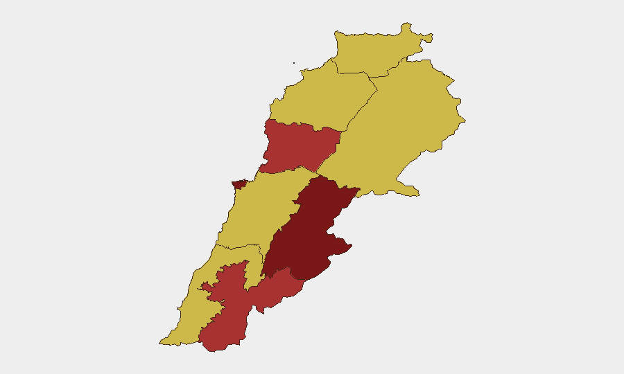
Situation Summary
Lebanon remains at acute risk (global rank #4, composite score 100) amid continued Israeli military operations despite a nominal ceasefire, with at least 24 confirmed deaths in the last 24–48 hours and systematic ceasefire violations reported across southern border regions. Simultaneous internal instability—including reported assassinations, sectarian tensions, and infrastructure collapse in Beirut and Tripoli—compounds the security environment. The combination of active cross-border hostilities, high civilian casualty rates, economic collapse (76.5% job losses in Nabatieh), and domestic political fracture indicates a deteriorating trajectory with no stabilization signals.
Key Developments
- Nabatieh al-Faqa drone strike (Monday, Jul 6): Israeli drone killed four civilians—including a school principal—in a vehicle; IDF cited entry into a declared "security zone"; Lebanon's Health Ministry confirmed deaths.
- South Lebanon security zone clashes (Jul 6–7): IDF reported eliminating an armed individual near Israeli positions; concurrent Lebanese reports of multiple drone and artillery violations in the same 48-hour window.
- Border shelling and flag-raising (Tuesday, Jul 7): National News Agency reported Israeli artillery strikes on southern border areas, intensive drone overflights, and IDF use of drone to raise Israeli flag on Ali al-Taher heights; also documented Israeli settler incursions under military protection.
- Countrywide strike casualties (last 24–48 hours): Health Ministry data cited by Al Jazeera indicates at least 24 killed across Lebanon from Israeli targeting of alleged Hezbollah positions; dozens more wounded.
- Tripoli residential collapse (Sunday, Jul 5; ongoing impact): Building in al-Tabbaneh neighborhood collapsed, causing fatalities and ongoing rescue operations; underscores infrastructure and urban safety risks in informal settlements.
- Labor crisis in southern governorates (Tuesday, Jul 7 data release): ILO report confirmed 76.5% job loss in Nabatieh and 43.2% in South Lebanon, with average income down 40%; amplifies socioeconomic instability and crime/unrest risk.
- Domestic political tensions (Jul 7–8): Multiple signals of sectarian and parliamentary disapproval; assassination reported; resistance movement condemnation and Christian public statements indicating internal fracture alongside external conflict.
Highest-Risk Areas
Beqaa Governorate (risk 100) and Beirut Governorate (risk 88.6) are the primary drivers of national risk, followed by Keserwan-Jbeil, Nabatieh, and North Governorate (78.9–70). Southern regions—South, Nabatieh, and Baalbek-Hermel—face direct cross-border military fire, drone strikes, and ceasefire violations; Beirut's risk reflects active internal political instability, assassination attempts, and infrastructure failures. Beqaa's highest ranking reflects both proximity to conflict zones and sectarian tension. Economic collapse in the south is rapidly degrading civilian movement safety and increasing informal security threats.
How GeoBit Would Assist
Security and duty-of-care teams should deploy AOI Monitoring & Early Warning on southern border zones (Nabatieh, South, Beqaa) for persistent ceasefire-violation detection and casualty reporting. Conflict & Military mapping combined with Satellite & Imagery analysis enables real-time verification of strike locations and force deployments. Alternative Route/Journey Planning via Routing & Network Analysis is essential for personnel movement; simultaneous OSINT fusion (X/Telegram/regional sources) and sentiment analysis on sectarian rhetoric will provide 24-hour early warning of internal escalation before mainstream reporting.
7-Day Outlook
Ceasefire violations are likely to persist or escalate, with Israeli operations continuing against suspected Hezbollah sites and Lebanese security forces stretched across multiple fronts. Internal sectarian and political friction will increase pressure on state institutions; risk of secondary incidents (industrial accidents, crime, protests) is elevated due to economic collapse and state fragility. Corporate and NGO personnel in Beirut and the south face heightened casualty and movement risk through mid-July.
Highest-Risk Areas — Ranked
| # | State / Region | Risk |
|---|---|---|
| 1 | Beqaa Governorate | 100 |
| 2 | Beirut Governorate | 88.6 |
| 3 | Keserwan-Jbeil Governorate | 78.9 |
| 4 | Nabatieh Governorate | 76 |
| 5 | North Governorate | 70 |
| 6 | Akkar Governorate | 70 |
| 7 | Mount Lebanon Governorate | 70 |
| 8 | South Governorate | 70 |
| 9 | Baalbek-Hermel Governorate | 70 |
Sources
Previous Daily Briefs
A new Lebanon brief is written every day — each with its own risk map and downloadable CSV. Here's the last week; use the calendar to go further back.
📅 Browse every day by calendar →
Highlighted days have a brief. Tap a day for that day's map & analysis, or “csv” for that day's dataset ($5).
Atlas — our AI intelligence desk — emails them this snapshot personally. Nothing else, no list.