Situation Summary
Lesotho remains a low-threat environment globally (rank #147, composite score 6) with no discrete security incidents tracked in the current reporting window. The primary disruption affecting the country is weather-related: severe snowfall and strong winds have disrupted cross-border travel, damaged homes, and caused livestock losses in high-altitude areas. Overall security trajectory remains stable, though seasonal weather hazards and localized socioeconomic pressures in urban centers warrant continued monitoring.
Key Developments
- Qacha's Nek Border Gate (southern Lesotho) – Temporarily closed as of 12 August 2026 due to severe snowfall and high winds; conditions affecting cross-border trade and travel.
- Ramatseliso's Gate (eastern border) – Remains closed as of 12 August 2026; snowfall and dangerous road conditions persist in mountainous regions.
- Livestock and property losses – Confirmed livestock deaths and home damage across high-altitude zones; humanitarian impact in rural districts, particularly Qacha's Nek and adjacent areas.
- Travel disruption ongoing – Strong winds and snow accumulation continue to affect internal and cross-border movement; no all-clear issued by 13 August.
No security, civil unrest, crime escalation, political instability, or infrastructure attacks were independently verified in Lesotho over the last 24–48 hours.
Highest-Risk Areas
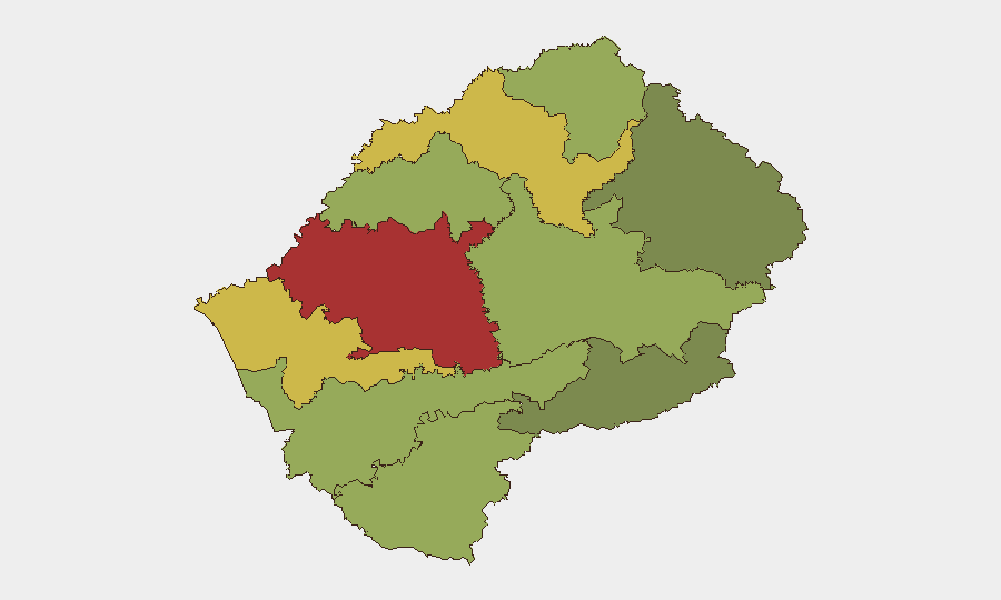
Maseru District ranks as the highest-risk sub-national zone (score 78), reflecting its status as the capital and primary commercial hub—concentrating population, economic activity, and routine crime vectors. Mafeteng (65) and Leribe (62) follow, likely driven by socioeconomic stressors, informal settlements, and cross-border dynamics with South Africa. Conversely, Qacha's Nek (28), though currently affected by weather disruption, ranks lowest in composite threat score, indicating that weather impacts are episodic rather than structural to long-term security risk in that district.
How GeoBit Would Assist
Security teams operating in Lesotho would deploy AOI Monitoring & Early Warning capabilities to track political stability, border-crossing status, and weather-infrastructure interactions in real time, alerting to sudden changes in Maseru, Mafeteng, and Leribe districts. Routing & Network Analysis would support contingency planning around border closures and alternative logistics routes, especially during seasonal disruptions. Environmental & Health monitoring and multi-language OSINT feeds would enable early detection of humanitarian crises or civil unrest that could escalate beyond current baseline risk.
7-Day Outlook
Snowfall is expected to persist in high-altitude areas over the coming days; border-gate reopening timelines remain uncertain. Security risk is projected to remain low absent major political or social triggers; weather-related disruptions will likely ease by mid-to-late week, restoring normal cross-border traffic. Maseru and other urban districts should be monitored for any downstream impacts on supply chains or informal-sector volatility, though no escalation is currently signaled.
Highest-Risk Areas — Ranked
| # | State / Region | Risk |
|---|---|---|
| 1 | Maseru District | 78 |
| 2 | Mafeteng District | 65 |
| 3 | Leribe District | 62 |
| 4 | Berea District | 58 |
| 5 | Mohale's Hoek District | 52 |
| 6 | Butha-Buthe District | 48 |
| 7 | Thaba-Tseka District | 45 |
| 8 | Quthing District | 42 |
| 9 | Mokhotlong District | 38 |
| 10 | Qacha's Nek District | 28 |
Sources
Previous Daily Briefs
A new Lesotho brief is written every day — each with its own risk map and downloadable CSV. Here's the last week; use the calendar to go further back.
📅 Browse every day by calendar →
Highlighted days have a brief. Tap a day for that day's map & analysis, or “csv” for that day's dataset ($5).
Atlas — our AI intelligence desk — emails them this snapshot personally. Nothing else, no list.