Situation Summary
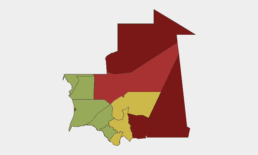
Mauritania remains classified at composite threat level 7 (moderate global rank). No discrete security incidents have been confirmed in the last 24–48 hours; the security environment reflects standing rather than acute risks. The highest concentrations of threat activity cluster in the northeastern and eastern border zones (Tiris Zemmour, Hodh Ech Chargui, Hodh El Gharbi), driven by persistent transnational militant and criminal networks operating across the Sahel. The overall trajectory remains stable, with no indication of imminent escalation in the current reporting window.
Key Developments
No security, conflict, civil-unrest, crime, political-instability, infrastructure, or travel-risk events meeting the 24–48 hour recency threshold have been verified from available sources. Recent web research yielded only archived items from early July 2026 and standing travel advisories; no current incident corroboration is available.
Background context (for situation awareness, not current development):
- German foreign ministry continues to advise against travel to remote Sahara/Sahel border areas, citing risks of attacks, kidnapping, and armed banditry—standing guidance reflecting the endemic threat posture in northeastern regions rather than a fresh event.
Highest-Risk Areas
The two Hodh regions (Ech Chargui at 85, El Gharbi at 80) and Tiris Zemmour (95) dominate the risk profile. These eastern and northeastern border zones are characterized by limited state capacity, porous boundaries with Algeria and Mali, and sustained presence of transnational armed groups and smuggling networks. Adrar (78) and Tagant (68) extend this corridor of elevated risk further west. In contrast, western and southern regions (Dakhlet Nouadhibou, Brakna, Trarza) present substantially lower composite scores (45–55), reflecting greater population density, state presence, and commercial activity. Geographic isolation and distance from central authority amplify vulnerability in the high-risk tier.
How GeoBit Would Assist
Security teams with personnel or assets in Mauritania would benefit from three primary GeoBit functions: AOI Monitoring & Early Warning to establish persistent watch on high-risk regions (particularly Tiris Zemmour and the Hodh zones) with automated alerting on cross-border activity, militant movement, or infrastructure disruption; Intel Sweep and multi-language OSINT (including regional Arabic-language feeds, Telegram networks, and Cridem intelligence sources) to capture emerging incidents and actor communications in real time; and Conflict & Military battle mapping combined with Network & Actor Analysis to track the disposition and operational tempo of armed groups and criminal networks. Route & Network Analysis would support contingency journey planning for staff movement in medium-risk regions.
7-Day Outlook
No acute developments are forecast in the immediate term. Risk remains concentrated in border zones and reflects chronic instability rather than sudden escalation. Security teams should maintain baseline vigilance protocols for northeastern operations and monitor regional Sahel developments (Mali, Niger cross-border spillover) as indirect drivers of Mauritanian threat dynamics.
Next update: 2026-08-07 or upon confirmed incident.
Highest-Risk Areas — Ranked
| # | State / Region | Risk |
|---|---|---|
| 1 | Tiris Zemmour | 95 |
| 2 | Hodh Ech Chargui | 85 |
| 3 | Hodh El Gharbi | 80 |
| 4 | Adrar | 78 |
| 5 | Tagant | 68 |
| 6 | Guidimaka | 65 |
| 7 | Assaba | 62 |
| 8 | Gorgol | 58 |
| 9 | Trarza | 55 |
| 10 | Inchiri | 52 |
| 11 | Brakna | 48 |
| 12 | Dakhlet Nouadhibou | 45 |
Sources
Previous Daily Briefs
A new Mauritania brief is written every day — each with its own risk map and downloadable CSV. Here's the last week; use the calendar to go further back.
📅 Browse every day by calendar →
Highlighted days have a brief. Tap a day for that day's map & analysis, or “csv” for that day's dataset ($5).
Atlas — our AI intelligence desk — emails them this snapshot personally. Nothing else, no list.