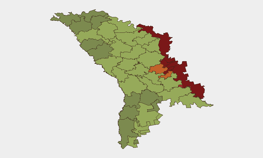
Situation Summary
Moldova remains at elevated risk from Russian airspace violations and spillover effects of the Ukraine conflict, despite a global threat ranking of #135 and zero tracked security events during the reporting week. Between 2–11 October, four confirmed airspace incursions and one low-altitude drone detonation occurred, with no casualties among civilian populations, though one projectile struck a passenger bus at a border crossing on 5 October, injuring one person. The Transnistrian territories (Left Bank of the Dniester, Dubăsari, Bender) continue to pose the highest localized risk; mainstream southern and central regions remain stable, though cross-border proximity to active Ukrainian combat zones sustains a persistent, low-intensity spillover hazard.
Key Developments
- 7 October, Limanske sector: National Army detected an unauthorized airspace incursion near the Ukraine border; the object exited Moldovan airspace toward Limanske within one minute of detection.
- 8 October, Chișinău: NATO Deputy Secretary General Radmila Shekerinska visited Moldova for talks with President Sandu on defence resilience, cyber defence, and hybrid threats—underscoring NATO concern for regional stability.
- 8 October, Chișinău: President Sandu stated that nine Russian drones had violated Moldovan airspace during the preceding seven days and that Russian strikes had damaged Ukrainian border crossings and disrupted regional energy and water infrastructure.
- Night of 10–11 October, Geamăna–Văratic area, Anenii Noi District: A low-altitude drone-like aircraft entered Moldovan airspace and detonated in open land; Moldova's air-surveillance systems did not track the object, indicating low-altitude penetration capability.
- Context (5 October incident, included in this week's retrospective reporting): A projectile ricocheted off border-crossing grounds, struck a passenger bus and control booth, and injured one person—the only recorded casualty from recent spillover incidents.
Highest-Risk Areas
The Transnistrian territories dominate the sub-national risk ranking, with the Left Bank of the Dniester (score 85), Dubăsari (82), and Bender (79) posing the greatest threat; these regions remain partially under Russian military influence and separated from Chișinău's effective control, creating ungoverned space and military exposure. Secondary risk concentrates in the northern and eastern borderlands (Rezina, Criuleni, Soroca, Căușeni, Ștefan Vodă), which are proximal to active Ukrainian combat and subject to spillover airspace violations and artillery debris. Chișinău (score 49), despite being the capital, ranks lower than border districts, reflecting its distance from the conflict zone; however, it remains a political and infrastructure target of secondary concern. Southern autonomous regions (Gagauzia, Taraclia) show moderate risk tied to Russian sympathies and proximity to the conflict, but no active instability.
How GeoBit Would Assist
Security teams with operations or personnel in Moldova should deploy AOI Monitoring & Early Warning capabilities on high-risk districts (Transnistrian territories, northern borderlands) to detect airspace violations, military movements, and infrastructure disruptions in near-real-time. Conflict & Military tracking (force structure, weapons-capability analysis) would clarify Russian and Ukrainian posture near Moldovan borders, while Satellite & Imagery analysis and GIS & Spatial Analysis would identify damage patterns, military buildups, and safe routing corridors. Intel Sweep and multi-language OSINT would capture Ukrainian and Russian operational signals and civilian-impact reporting that precede formal incident disclosure.
7-Day Outlook
Airspace violations are likely to persist as long as Russian air operations against Ukraine continue; the 7–11 October cluster suggests a weekly or bi-weekly incursion rate. Energy and water infrastructure disruptions from cross-border strikes may recur, particularly in northern and eastern districts. Transnistrian stability should remain stable but ungoverned and monitored.
Highest-Risk Areas — Ranked
| # | State / Region | Risk |
|---|---|---|
| 1 | Administrative-Territorial Units of the Left Bank of the Dniester | 85 |
| 2 | Dubăsari | 82 |
| 3 | Bender | 79 |
| 4 | Criuleni | 75 |
| 5 | Rezina | 58 |
| 6 | Taraclia | 55 |
| 7 | Gagauzia | 54 |
| 8 | Căușeni | 53 |
| 9 | Soroca | 52 |
| 10 | Ștefan Vodă | 51 |
| 11 | Orhei | 50 |
| 12 | Chișinău | 49 |
Sources
Previous Weekly Briefs
A new Moldova brief is written every Monday, covering the week — each with its own risk map and downloadable CSV. Use the calendar to go further back.
- October 6, 2026
- September 29, 2026
- September 22, 2026
- September 15, 2026
- September 8, 2026
- September 2, 2026
- August 31, 2026
📅 Browse past briefs by calendar →
Highlighted days have a brief. Tap a day for that day's map & analysis, or “csv” for that day's dataset ($5).
Atlas — our AI intelligence desk — emails them this snapshot personally. Nothing else, no list.