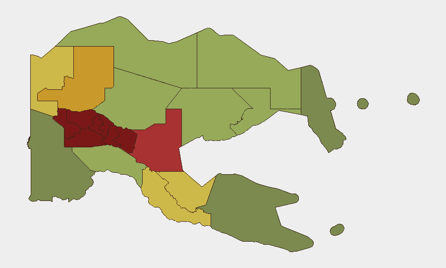
Situation Summary
Papua New Guinea faces persistent fragmented security threats across multiple provinces, with a composite national risk score of 21 and no significant trend change in the past 24–48 hours. However, recent incidents confirm active violent crime, tribal conflict, and maritime hazards affecting foreign nationals and critical infrastructure. The Highland provinces (Southern Highlands, Enga, Hela, Eastern Highlands, Western Highlands) remain the highest-risk zones, while Port Moresby and secondary urban centers continue to experience armed crime and detention-facility incidents.
Key Developments
- Lihir Island, New Ireland Province (4 Aug): A vessel named *Zhephir* reportedly sank off Mali Island with seven Chinese nationals aboard; all seven are believed to have died. The incident was reported as occurring on 4 August and highlights ongoing maritime hazard risk for foreign nationals in PNG waters.
- Port Moresby, National Capital District (overnight 3–4 Aug): Twenty Correctional Services personnel were detained by police following a disorderly conduct incident involving illegal firearm discharge, assault, and threats against staff and families. The incident signals internal security-force instability and potential duty-of-care risk for organizations in the capital.
- Laiagam, Enga Province (2–3 Aug, weekend): Three people were killed in tribal violence. The Enga Provincial Police Commander has appealed for calm among Makol and Makol Tap communities and warned of heightened risk of further violence pending investigation.
- Nine Mile, Lae, Morobe Province (recent overnight incident): An attempted armed robbery by criminal gangs prompted community retaliation, resulting in one gang member beaten to death and another critically injured. The incident reflects organized gang activity and volatile civilian response in Lae's peripheral zones.
- Wewak, East Sepik Province (early morning 2 Aug): Police are investigating the suspected murder of Richmond Aaron. The case remains under active investigation by the East Sepik Provincial Police.
- Port Moresby (ongoing investigation, reported last 48h): Police are investigating the death of a 20-year-old male who was assaulted at Rainbow Cash & Carry on 16 June and died while receiving treatment; the case has been classified as homicide.
- Enga Province (Operation KUMUL 23, reinforced in latest update): The Police Tactical Group continues ground patrols targeting illegal firearms and violent offenders. While patrol activity was documented on 27 June, the operation is referenced as ongoing, indicating sustained heavy security deployments and movement restrictions in Enga.
Highest-Risk Areas
Southern Highlands, Enga, and Hela provinces dominate the risk profile (scores 98, 96, and 94 respectively), driven by endemic tribal conflict, limited state police presence, and prevalence of illegal weapons. The Eastern Highlands, Western Highlands, and Jiwaka follow closely (92, 90, 88), reflecting similar structural drivers. Port Moresby and Morobe Province (NCD at 85, Morobe at 78) show elevated urban crime—armed robbery, gang violence, and institutional instability—affecting corporate and expatriate populations. The pattern reflects geographic concentration of violence in the Highlands coupled with organized crime in urban centers.
How GeoBit Would Assist
Security teams should deploy AOI Monitoring & Early Warning on high-risk provinces (Enga, Southern Highlands, Morobe) to detect tribal violence escalation and armed gang activity in real time. Network & Actor Analysis and OSINT fusion (Telegram, social media, police statements) enable rapid corroboration of maritime, criminal, and conflict incidents before official confirmation. Routing & Network Analysis supports duty-of-care teams in identifying alternative transit routes away from Laiagam, Nine Mile, and other active incident zones.
7-Day Outlook
Violence in the Highlands is expected to remain localized but cyclical; the Laiagam killings may trigger retaliatory action within 7–10 days absent effective police mediation. Urban crime in Port Moresby and Lae will likely continue at baseline levels. Maritime hazards and ongoing police operations in Enga warrant sustained monitoring for foreign nationals and supply-chain movements.
Highest-Risk Areas — Ranked
| # | State / Region | Risk |
|---|---|---|
| 1 | Southern Highlands | 98 |
| 2 | Enga | 96 |
| 3 | Hela | 94 |
| 4 | Eastern Highlands | 92 |
| 5 | Western Highlands | 90 |
| 6 | Jiwaka | 88 |
| 7 | National Capital District | 85 |
| 8 | Simbu | 82 |
| 9 | Morobe | 78 |
| 10 | East Sepik | 72 |
| 11 | Sandaun | 68 |
| 12 | Oro | 66 |
Sources
Previous Daily Briefs
A new Papua New Guinea brief is written every day — each with its own risk map and downloadable CSV. Here's the last week; use the calendar to go further back.
📅 Browse every day by calendar →
Highlighted days have a brief. Tap a day for that day's map & analysis, or “csv” for that day's dataset ($5).
Atlas — our AI intelligence desk — emails them this snapshot personally. Nothing else, no list.