Situation Summary
Slovakia remains a low-threat environment globally (rank #113, score 14), with no tracked security incidents in the current window. However, the foiled arson plot against a Ukrainian drone factory in eastern Slovakia on 25–26 August has elevated attention to critical infrastructure protection and exposed potential supply-chain sabotage risks tied to ongoing regional geopolitical tensions. Authorities have responded with reinforced security measures, and the incident underscores asymmetric threats to defense-related manufacturing in NATO territory.
Key Developments
- Foiled arson/sabotage attempt at Skyeton drone factory, Prešov region (25–26 Aug, details released 27 Aug): Slovak police thwarted a planned incendiary attack on the Ukrainian-owned facility. Three foreign nationals (two Latvians, one Ukrainian) were arrested; one suspect extradited to Germany. Seized materials included improvised napalm, pyrotechnic devices, and a handwritten attack plan. Approximately 70 employees could have been present; no casualties or property damage occurred. A group calling itself "Global Citizens Against War 1984" claimed responsibility via Reuters.
- Slovak police announce heightened security measures nationwide (27 Aug, 15:41 local): The Police Corps announced "appropriate preventive measures" to reinforce protection of critical and defense-related infrastructure in response to the Skyeton incident, signaling an elevated but controlled security posture.
- D3 motorway closure, Svrčinovec–Skalité section (in effect through 27 Aug): Full closure of the D3 northbound segment, including tunnels, due to extended construction works near the Czech/Polish border. Causes significant traffic disruption and delays on alternate routes; civil engineering issue, not security-driven.
- Bratislava traffic restrictions ongoing (22–28 Aug): Multiple partial lane closures and diversions on Most SNP bridge, Staromestská, Jarošova Street, and D2 overpasses due to maintenance and reconstruction. One lane of Most SNP remains closed through end of August.
Highest-Risk Areas
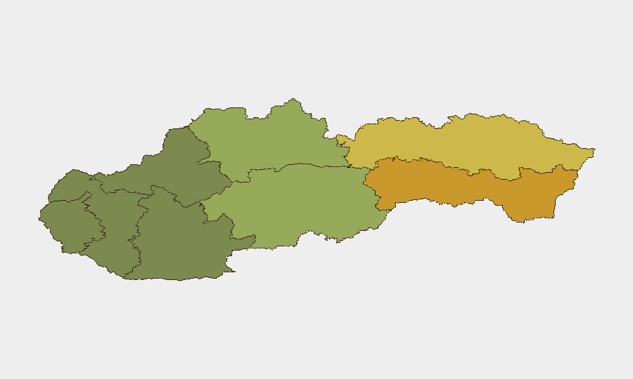
Košice and Prešov regions in eastern Slovakia drive the sub-national risk ranking (scores 72 and 68 respectively), with Košice notably elevated. The Skyeton incident in Prešov reinforces this concentration: the region hosts cross-border industrial activity and lies proximate to Ukrainian territory, increasing exposure to supply-chain sabotage and politically motivated violence. Banská Bystrica (score 55) ranks third; Bratislava (score 28), despite being the capital, remains lower-risk, reflecting concentration of threats in the economically active east. Western and central regions (Trenčín, Trnava) show substantially lower risk profiles.
How GeoBit Would Assist
Duty-of-care teams can leverage GeoBit's AOI Monitoring & Early Warning to maintain persistent surveillance of Skyeton and similar defense-related manufacturing sites, with real-time alerting on suspicious activity, access patterns, or supply-chain disruptions. Intel Sweep, multi-language OSINT, and X/Telegram monitoring enable rapid identification of emerging threat narratives and fringe actors (e.g., "Global Citizens Against War 1984"), corroborating claims of responsibility and tracking network signals. Routing & Network Analysis allows security teams to map alternative logistics and personnel transit routes around infrastructure closures and high-risk zones in Košice and Prešov, ensuring continuity for operations and travel.
7-Day Outlook
No escalation is forecast in the immediate term; police reinforcement and media coverage of the foiled plot likely deter follow-on attempts over the next week. Authorities will sustain elevated vigilance at critical infrastructure; personnel and asset movements should anticipate heightened security screening and potential delays. Road conditions will normalize once D3 and Bratislava construction work completes by end of month, restoring normal transit corridors.
Highest-Risk Areas — Ranked
| # | State / Region | Risk |
|---|---|---|
| 1 | Region of Košice | 72 |
| 2 | Region of Prešov | 68 |
| 3 | Region of Banská Bystrica | 55 |
| 4 | Region of Žilina | 42 |
| 5 | Region of Nitra | 35 |
| 6 | Region of Bratislava | 28 |
| 7 | Region of Trenčín | 22 |
| 8 | Region of Trnava | 18 |
Sources
Previous Daily Briefs
A new Slovakia brief is written every day — each with its own risk map and downloadable CSV. Here's the last week; use the calendar to go further back.
- August 25, 2026
- August 23, 2026
- August 21, 2026
- August 19, 2026
- August 17, 2026
- August 15, 2026
- August 13, 2026
📅 Browse every day by calendar →
Highlighted days have a brief. Tap a day for that day's map & analysis, or “csv” for that day's dataset ($5).
Atlas — our AI intelligence desk — emails them this snapshot personally. Nothing else, no list.