Situation Summary
Solomon Islands remains a stable, low-threat environment with no acute security incidents reported in the last 24–48 hours. The country ranks 145th globally on composite threat, with routine infrastructure maintenance, planned military operations, and maritime enforcement dominating recent activity. Risk remains concentrated in Honiara and surrounding Guadalcanal province, driven by urban crime and gang activity rather than political violence or organized conflict. The overall security trajectory is stable with no indicators of imminent deterioration.
Key Developments
- Honiara water-supply disruption (West Kola Ridge, 18 August 2026): Solomon Water announced repair of a burst main pipe affecting multiple suburbs including West Kola, Kolale, and Matariu. Water was shut off during maintenance; no timeline for full restoration was provided in last available reports. Minor public-health and service-confidence risk if repairs extend beyond 48 hours.
- Maritime surveillance operations (Solomon Islands EEZ, 18–19 August 2026): Australian Defence Force and Pacific Islands Forum Fisheries Agency conducted aerial patrols over approximately 320,000 km² of the Solomon Islands' exclusive economic zone, identifying 16–19 vessels of interest engaged in suspected illegal, unreported, and unregulated (IUU) fishing and potential transnational maritime crime. No specific interdictions or confrontations were reported as of the last update.
- Planned UXO disposal operations (Western and Choiseul provinces, ongoing through 27 August 2026): Controlled demolition of unexploded ordnance from WWII-era deposits continues in Western and Choiseul provinces with security cordons in place. No accidents or unplanned incidents reported as of 18 August.
- Western Border Outpost operational (Shortland Islands, 17 August 2026): Australia and Solomon Islands jointly opened a new border monitoring facility in the Shortland Islands to strengthen maritime and air surveillance and bilateral security cooperation. This enhancement does not reflect a new threat but rather a structural capacity upgrade.
Highest-Risk Areas
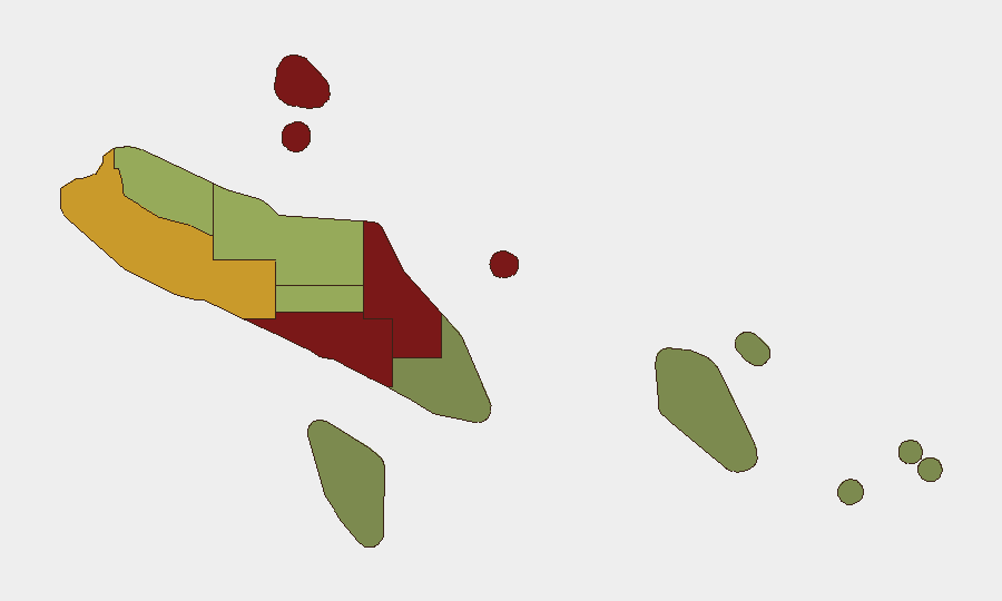
Honiara (risk 92) and Guadalcanal province (risk 88) together account for the majority of Solomon Islands' security risk, primarily driven by urban crime, gang activity, and occasional communal tensions rather than political instability. Malaita province (risk 85) ranks third, reflecting similar urban-crime dynamics in secondary population centers and a history of inter-provincial friction. Western province (risk 72) shows elevated risk tied to maritime crime and border-security challenges. All other provinces register moderate to low risk, with Temotu (risk 18) the safest. Crime and gang violence—not political conflict or terrorism—drive the ranking.
How GeoBit Would Assist
Security teams with personnel or assets in Solomon Islands should deploy AOI Monitoring & Early Warning focused on Honiara, Guadalcanal, and Malaita to detect sudden spikes in gang activity, protest organizing, or crime patterns; pair this with multi-language OSINT and X/Twitter OSINT to track social-media indicators of civil tension or criminal coordination. Maritime & Aviation tracking coupled with conflict and crime-specific search capabilities would enable continuous monitoring of IUU-fishing activity and transnational maritime crime in the EEZ, with alert thresholds for vessel clustering or incursions into territorial waters. GIS & Spatial Analysis can map UXO-disposal cordons and infrastructure disruptions to route personnel safely around localized hazards.
7-Day Outlook
No significant escalation is anticipated over the next seven days. Routine infrastructure repairs, maritime enforcement, and planned military operations will likely continue without incident. Security teams should maintain baseline awareness of crime in Honiara and monitor water-supply and transport networks for service disruptions, but no policy or travel changes are warranted based on current trajectory.
Highest-Risk Areas — Ranked
| # | State / Region | Risk |
|---|---|---|
| 1 | Honiara | 92 |
| 2 | Guadalcanal | 88 |
| 3 | Malaita | 85 |
| 4 | Western | 72 |
| 5 | Choiseul | 58 |
| 6 | Isabel | 52 |
| 7 | Central Province | 48 |
| 8 | Makira-Ulawa | 38 |
| 9 | Rennell and Bellona | 22 |
| 10 | Temotu | 18 |
Sources
Previous Daily Briefs
A new Solomon Islands brief is written every day — each with its own risk map and downloadable CSV. Here's the last week; use the calendar to go further back.
- August 18, 2026
- August 16, 2026
- August 14, 2026
- August 12, 2026
- August 10, 2026
- August 8, 2026
- August 6, 2026
📅 Browse every day by calendar →
Highlighted days have a brief. Tap a day for that day's map & analysis, or “csv” for that day's dataset ($5).
Atlas — our AI intelligence desk — emails them this snapshot personally. Nothing else, no list.