Situation Summary
Suriname remains a low-threat environment globally (composite score 6/100) with no major security incidents recorded in the past week. The security picture is stable in the capital and western lowlands, but interior and eastern border regions face elevated risk from organized crime, informal armed groups, and limited state presence. The political environment shows friction within the ruling coalition over appointments and governance, but no immediate destabilization risk.
Key Developments
- Paramaribo — 23 September 2026: Germany's Foreign Office assessed Suriname as generally calm but warned that short-notice protests and demonstrations could occur in the capital, potentially causing localized violence or traffic disruption. The assessment also flagged pickpocketing, armed robbery, vehicle break-ins, and occasional piracy near coastal waters as active travel-security concerns.
- Paramaribo (Latour and Kwatta districts) — 22 September 2026: Police reported two separate vehicle burglaries in which two handguns were stolen. The incidents underscore ongoing property crime and arms leakage in the metropolitan area.
- Paramaribo — 22 September 2026: Police detained two suspects in separate investigations into suspected online fraud, indicating cybercrime remains an active threat vector in the capital.
- Suriname-wide (political) — 24 September 2026: ABOP leader Ronnie Brunswijk publicly stated that coalition agreements with President Jennifer Simons were not being honored, citing disputes over state-entity appointments (Grassalco, Canawaima, TAS) and senior security posts (police chief, national-security director). While no unrest has resulted, the friction signals ongoing governance tension and potential for cabinet instability.
Highest-Risk Areas
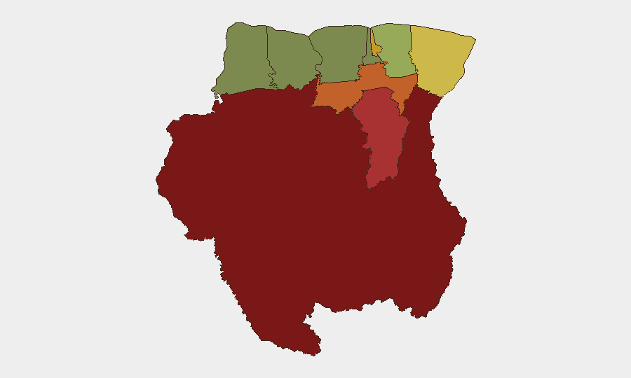
Interior and border regions dominate Suriname's risk profile. Sipaliwini (risk 92) and Brokopondo (risk 78)—both in the sparsely populated, jungle-dominated interior—face endemic challenges from informal armed groups, narcotics trafficking, and minimal state authority. Para (74) and Marowijne (68) on the eastern and southern borders are vulnerable to cross-border smuggling and spillover conflict. Paramaribo (71), the capital and economic hub, concentrates petty and organized crime, armed robbery, and demonstration risk. By contrast, western and northern districts (Nickerie, Coronie, Saramacca) remain comparatively stable, reflecting better infrastructure, population density, and police presence.
How GeoBit Would Assist
Security teams with personnel or assets in Suriname should deploy AOI Monitoring & Early Warning on Paramaribo and border districts (Marowijne, Para, Sipaliwini) to detect protest mobilization, armed-group activity, and trafficking movements in real time. OSINT Fusion & Corroboration across local police reports, political communications, and cross-border intelligence feeds will surface emerging coalition instability or security-force leadership changes that could affect duty-of-care compliance. Routing & Network Analysis enables identification of safer transit corridors in high-risk interior and coastal zones, critical for operations in Sipaliwini and Brokopondo.
7-Day Outlook
No acute security crisis is anticipated in the coming week. Political friction is likely to persist but remains manageable within existing coalition structures. Standard risks—petty crime in Paramaribo, informal-group activity in the interior, and coastal piracy—will continue; organizations should maintain baseline security protocols and monitor for any acceleration in armed-group or protest signaling, particularly ahead of any scheduled political or economic announcements.
Highest-Risk Areas — Ranked
| # | State / Region | Risk |
|---|---|---|
| 1 | Sipaliwini | 92 |
| 2 | Brokopondo | 78 |
| 3 | Para | 74 |
| 4 | Paramaribo | 71 |
| 5 | Marowijne | 68 |
| 6 | Commewijne | 42 |
| 7 | Wanica | 38 |
| 8 | Saramacca | 29 |
| 9 | Coronie | 12 |
| 10 | Nickerie | 8 |
Sources
Previous Weekly Briefs
A new Suriname brief is written every Monday, covering the week — each with its own risk map and downloadable CSV. Use the calendar to go further back.
- September 22, 2026
- September 15, 2026
- September 8, 2026
- September 1, 2026
- August 29, 2026
- August 26, 2026
- August 23, 2026
📅 Browse past briefs by calendar →
Highlighted days have a brief. Tap a day for that day's map & analysis, or “csv” for that day's dataset ($5).
Atlas — our AI intelligence desk — emails them this snapshot personally. Nothing else, no list.