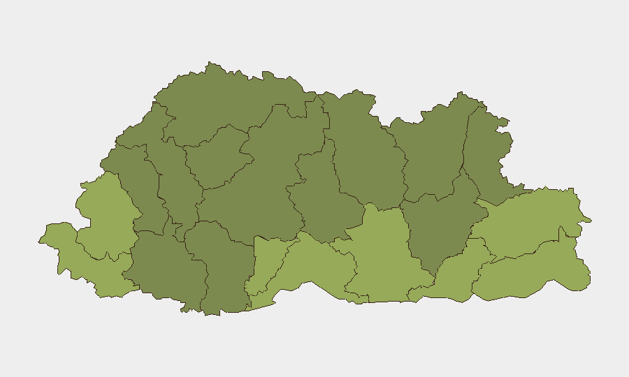
Situation Summary
Bhutan remains one of the lowest-threat operating environments globally, with a composite threat score of 2 and no tracked security events in the current reporting window. No verified security incidents, civil unrest, or infrastructure disruptions were identified in the last 24–48 hours. The country's stable political environment and low crime rates continue to support routine business and personnel operations, though border-region districts warrant elevated monitoring due to geographic and historical factors.
Key Developments
No discrete security incidents, civil unrest, or infrastructure disruptions were confirmed in Bhutan during the last 24–48 hours.
*Note:* A network connectivity disruption affecting parts of Bhutan was reported for July 18–19, 2026 (outside the current 24–48 hour window) and should not be treated as an active development. Teams relying on telecom or internet-dependent operations in affected districts are advised to confirm current service status directly with local providers.
Highest-Risk Areas
Samtse, Sarpang, and Haa Districts rank as the highest-risk sub-national zones (scores 58, 55, and 52 respectively), reflecting geographic proximity to international borders and historical cross-border movement patterns. These districts merit enhanced due diligence for operations involving personnel travel, supply-chain routing, or extended stays. Mid-tier risk zones (Pemagatshel, Samdrup Jongkhar, Tsirang) should receive standard security protocols. Central and northern districts (Thimphu area, Lhuntse, Gasa) carry substantially lower risk profiles and support routine operations with baseline precautions.
How GeoBit Would Assist
Teams with personnel or assets in Bhutan's border districts can use GeoBit's AOI Monitoring & Early Warning capability to establish persistent surveillance of Samtse, Sarpang, and Haa, with automated alerts on cross-border movement, civil unrest, or infrastructure disruption. OSINT Fusion (X/Twitter, Telegram, local media, multi-language search) would enable continuous intelligence collection to catch emerging developments before they impact operations. Routing & Network Analysis supports alternative journey planning if primary routes become disrupted, and Risk & Threat Assessment can be refreshed weekly or event-triggered to inform duty-of-care decisions for personnel deployments.
7-Day Outlook
No imminent security escalation is forecast for Bhutan in the next seven days. Routine monitoring of border-region districts should continue, with particular attention to seasonal weather patterns and infrastructure maintenance that may affect transportation networks. Teams should confirm telecom and power availability for any critical operations in the three highest-risk districts and maintain standard consular and embassy contact protocols.
Highest-Risk Areas — Ranked
| # | State / Region | Risk |
|---|---|---|
| 1 | Samtse District | 58 |
| 2 | Sarpang District | 55 |
| 3 | Haa District | 52 |
| 4 | Pemagatshel District | 50 |
| 5 | Samdrup Jongkhar District | 48 |
| 6 | Tsirang District | 45 |
| 7 | Zhemgang District | 42 |
| 8 | Trashigang District | 40 |
| 9 | Mongar District | 38 |
| 10 | Gasa District | 35 |
| 11 | Lhuntse District | 32 |
| 12 | Wangdue Phodrang District | 30 |
Sources
Previous Daily Briefs
A new Bhutan brief is written every day — each with its own risk map and downloadable CSV. Here's the last week; use the calendar to go further back.
📅 Browse every day by calendar →
Highlighted days have a brief. Tap a day for that day's map & analysis, or “csv” for that day's dataset ($5).
Atlas — our AI intelligence desk — emails them this snapshot personally. Nothing else, no list.